| Saturday | Saturday Night | Sunday | |
|---|---|---|---|
| Cloud Cover: | Continued mild with showers developing. | A cold front enters our area with increasing precipitation. | Cooler with light to moderate snow. |
| Temperatures: | 29-41 deg. F. | 14-22 deg. F. | 23-33 deg. F. |
| Wind Direction: | West-southwest | South-southwest | North - east |
| Wind Speed: | 11-13 mph with gusts to 28 | 8-10 mph | 6-8 mph |
| Snowfall: | 0-2 in. | 2-3 in. | 2-5 in. |
| Snow Line: |
Whitefish Range
Swan Range
Flathead Range and Glacier National Park
How to read the forecast
The avalanche danger remains elevated due to warming temperatures and continued windy conditions. Natural and human triggered avalanches have been observed over the past 2 days. The avalanche danger is CONSIDERABLE and human triggered avalanches are likely. Dangerous avalanche conditions exist and careful snow pack evaluation, cautious route-finding, and conservative decision making are essential.

3. Considerable
?
Above 6500 ft.
3. Considerable
?
5000-6500 ft.
3. Considerable
?
3500-5000 ft.
- 1. Low
- 2. Moderate
- 3. Considerable
- 4. High
- 5. Extreme
-
Type ?
-
Aspect/Elevation ?

-
Likelihood ?CertainVery LikelyLikelyPossible
 Unlikely
 -
Size ?HistoricVery LargeLargeSmall

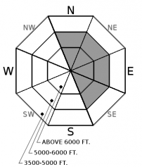
Call it what you will, but I am referring to our recent weather event as the "storm of the decade". This is due to the quantity and quality of the low density snow that fell since last weekend. This storm left copious amounts of low density snow (up to 59 inches since last Sunday) at mid and upper elevations that is now available for transport. Winds were surprisingly quiet for most of the storm but have increased over the past 48 hours. Expect to find thick slabs in favored windy locations across our area, especially in the alpine. In more protected areas expect to find thinner slabs. Regardless, these slabs need time to settle and strengthen. In exposed areas expect to find these slabs on cross-loaded mid slope features like spur ridges, tree islands, and rock out crops. Identify wind loaded terrain by looking for smooth, rounded features on the snow surface.
In many locations the wind and abundant snow formed large cornices. With continued warming temperatures keep a safe distance back from these while traveling above and avoid traveling below them.
-
Type ?
-
Aspect/Elevation ?

-
Likelihood ?CertainVery LikelyLikelyPossible
 Unlikely
 -
Size ?HistoricVery LargeLargeSmall

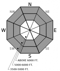
Continued warming temperatures, combined with recent dense snow, is creating a storm slab problem. These slabs are forming on top of a thick layer of low density snow forming an "upside down" snowpack. A good example of this problem is the snowboarder triggered large storm slab avalanche yesterday in the Skook Chutes of the southern Whitefish Range (observation). Yesterday morning's advisory recommended choosing conservative terrain to recreate in and I will reemphasize that again today. Even though the storm is essentially over, the storm slab problem is actually increasing due to the warming temperatures. Pay attention to obvious signs of instability like recent avalanches, shooting cracks, and collapsing in the snow pack.
-
Type ?
-
Aspect/Elevation ?

-
Likelihood ?CertainVery LikelyLikelyPossible
 Unlikely
 -
Size ?HistoricVery LargeLargeSmall

Temperatures have been at or above freezing at most low elevation locations over the past 24 hours. At select mid elevation locations temperatures have hovered around the freezing mark. Recent rain, combined with another day of warm temperatures, will keep the risk of wet loose slides a possibility today. Yesterday, on our ski descent in the Flathead Range, we found it impossible to not initiate rollerballs on each turn. These rollerballs quickly grew impressively large. Loose wet avalanches can move fast and entrain a lot of snow. Avoid terrain traps like narrow gullies, trees, and cliffs that can amplify the effect of even a small loose wet avalanche.
Conditions can rapidly deteriorate during these warming trends so is important to pay attention to changing conditions. Additional heavy, wet snow, prolonged sun exposure, or rain-on snow will increase the danger. The abundant, low density snow that fell early in the week is becoming less stable as recent rising temperatures and increased winds contribute to slab formation.
Join the Flathead Avalanche Center, Jesco Marine and Power Sports, and Bonsai Brewing Project on Saturday, March 4 for an afternoon of companion rescue. Various stations will be set up around the Bonsai Brewery with raffle tickets awarded for every station completed. Stop by for one station, or all of them, any time after 2:00 pm. The final raffle will be drawn at 6:30 pm.
Friday: A snowboarder triggered a 3-4' deep avalanche in the Skook Chutes, in the southern Whitefish Range, but fortunately was uninjured (observation). FAC staff were in the Apgar Range yesterday and experienced multiple collapses (whumpfs) and shooting cracks between 4000 and 5200 feet (summit of Apgar Mt.). Guy and Mark traveled into Cascade Creek, in the Flathead Range, where they found moist snow at low elevations that resulted in numerous rollerballs on their descent. At upper elevations they noted nearly 50" of settled snow on top of the February 16 rain crust. Active wind transport was observed and a recent slab avalanche was evident in Rescue Creek.
Thursday: A snowboarder triggered a storm slab avalanche in an area known as Chicken Bones in the southern Whitefish Range (observation). BNSF Avalanche Safety Team reported 3 natural wind slab avalanches that occurred in the John F Stevens Canyon. 2 were reported in the Shed 7 slide path, and 1 in the Infinity Path. All were estimated at 1 foot deep and propagated about 50 meters wide. Skiers on Paola Ridge in the Flathead Range experienced collapsing in the snowpack at low elevations (between 3500-5000 feet). They dug a pit and performed stability tests and found instability near the Feb. 10 rain crust. At 7000 feet they dug another pit and with hard force in an Extended Column Test found a layer that was 20 cm above the rain crust that fractured and propagated. This party also noted rain below 4000 feet on their egress. Skiers on Peak 6996 in southern Glacier National Park had consitent results in Extended Column Tests. A layer within last weeks storm snow fractured and propagated nearly 2 feet deep with moderate force (ECTP 16).
Wednesday: Skiers in the Flathead Range reported unstable storm and wind slabs. They noted cracking and remote triggering avalanches while traveling along a ridgeline. Winds were in excess of 50 mph and they found wind slabs that were 2.5 feet thick.
See below for all observations this season.
Yesterday was a mild day with some of the warmest temperatures of the year. We received an additional 0.1 - 0.7 inches of snow water equivalent which equates to several inches of relatively dense snow. Winds were out of the southwest at 3-24 mph with gusts from 19-44 mph. Currently, temperatures above 6000 feet range from 25-32ºF, and winds continue out of the southwest at 10-24 mph with gusts of 18 - 34. Today should see temperatures reaching the mid 30s with southwest winds at 15-20 mph and gusts in the 30s. Showers are expected to increase later this afternoon and overnight.
| 0600 temperature: | 25-32 deg. F. |
| Max. temperature in the last 24 hours: | 26-34 deg. F. |
| Average wind direction during the last 24 hours: | West-southwest |
| Average wind speed during the last 24 hours: | 3-24 mph |
| Maximum wind gust in the last 24 hours: | 19-44 mph |
| New snowfall in the last 24 hours: | 1-4 inches |
| Total snow depth: | 92-123 inches |
This advisory applies only to backcountry areas outside established ski area boundaries. This advisory describes general avalanche conditions and local variations always occur. This advisory expires at midnight on the posted day unless otherwise noted. The information in this advisory is provided by the USDA Forest Service who is solely responsible for its content.


