| Monday | Monday Night | Tuesday | |
|---|---|---|---|
| Cloud Cover: | Light showers with mild conditions. | Showers increasing. | Light to moderate snow with continued mild conditions. |
| Temperatures: | 31-40 deg. F. | 25-33 deg. F. | 30-39 deg. F. |
| Wind Direction: | South-southwest | Southwest | South-southwest |
| Wind Speed: | 8-9 mph with gusts to 23 | 11-13 mph with gusts to 28 | 14-16 mph with gusts to 36 |
| Snowfall: | 1-2 in. | 1-3 in. | 2-5 in. |
| Snow Line: |
Whitefish Range
Swan Range
Flathead Range and Glacier National Park
How to read the forecast
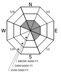
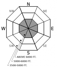
The avalanche danger is MODERATE above 6000 feet where human triggered avalanches remain possible. Recent snowfall and wind formed fresh wind slabs at upper elevations. Lingering storm slab instability should be expected in areas favored by our last storm. In some locations both wind and storm slabs formed on a crust adding to their instability. Evaluate all wind loaded terrain, along with areas that received more recent snowfall, before committing to a slope. The danger below 6000 feet is LOW.

2. Moderate
?
Above 6500 ft.
1. Low
?
5000-6500 ft.
1. Low
?
3500-5000 ft.
- 1. Low
- 2. Moderate
- 3. Considerable
- 4. High
- 5. Extreme
-
Type ?
-
Aspect/Elevation ?

-
Likelihood ?CertainVery LikelyLikelyPossible
 Unlikely
 -
Size ?HistoricVery LargeLargeSmall

The fresh snow that we enjoyed yesterday was accompanied by light to moderate winds with moderate to strong gusts. Due to our current southwest flow pattern these winds have drifted this snow onto typical leeward slopes on the eastern side of the compass. Due to the lack of recent mid elevation snowfall these slabs should be confined to upper elevation locations. In some locations these slabs were deposited onto a rain crust or a relatively slippery layer of dense snow. Rounded pillows near ridgelines is a tell tale sign of a wind slab. Evaluate all wind loaded terrain before recreating on it.
-
Type ?
-
Aspect/Elevation ?

-
Likelihood ?CertainVery LikelyLikelyPossible
 Unlikely
 -
Size ?HistoricVery LargeLargeSmall

The storm Saturday night/Sunday morning deposited up to 8" of new snow at favored upper elevation locations. Yesterdays mild conditions helped to stabilize this layer. However, in some locations, this new snow was deposited onto a crust or a smooth dense layer which added to the instability associated with this slab. Therefore, we should be cognizant of this layer for another day. These storm slabs are thin and should be easy to identify. Cracking under your skis or machine is an obvious sign of a fresh slab.
We have not observed or been informed of any avalanches occurring on the January 19th crust or any other persistent weak layer since late last week. However, in some places stability tests are still showing reactive results around the January 19 crust and, in isolated locations, the depth hoar at the base of the snowpack is reactive as well. Even though these layers have not produced any avalanches lately, it is still important to be aware that in some locations in the advisory area there is a poor snowpack structure with buried weak layers that may still be reactive. Because these weak layers do not always present obvious signs of instability, digging into the snowpack is the best way to determine their location and reactivity. Also you are more likely to find and/or trigger one of these weak layers in steep rocky terrain that typically has a more shallow snowpack.
We would like to thank all those who have been submitting observations recently. These observations are invaluable and improve our forecasts. Several observers have submitted reports from across the advisory area documenting the widespread avalanche activity from last week (see our Observations Page). Thank you!
Saturday: Mark was in Rescue Creek where he noted evidence of the February 4-10 avalanche cycle. At low elevations the surface crust broke down quickly and the moist snowpack became unsupportable. At mid elevations this crust seemed to survive the day better. Riders in the Wounded Buck area of the Swan Range noted evidence of a large wet avalanche that may have been the result of the February 8-9 rain event.
Friday: Zach (FAC intern) and Mark traveled to the Skookoleel Ridge area of the Whitefish Range. We noted up to 4 inches of dense snow on top of a rain crust at upper elevations. Stability test results in our snowpits showed instabilities within the new snow and around the February 8 rain crust. No propagation was observed in our tests.
See below for all observations this season.
Mild conditions with minimal precipitation has occured over the past 24 hours. Winds have been light to moderate with moderate to strong gusts. Currently, above 6000 feet, temperatures are 20-28°F with light winds out of the southwest at 1-8 mph with gusts of 4-15 mph. Light showers are expected today with continued mild conditions and temperatures in the low to mid 30s ºF above 6000 feet and into the upper 30s ºF at elevations below this. Light southwest winds with moderate gusts will continue through the day.
| 0600 temperature: | 20-28 deg. F. |
| Max. temperature in the last 24 hours: | 27-36 deg. F. |
| Average wind direction during the last 24 hours: | Southwest |
| Average wind speed during the last 24 hours: | 1-21 mph |
| Maximum wind gust in the last 24 hours: | 14-37 mph |
| New snowfall in the last 24 hours: | 0-2 inches |
| Total snow depth: | 75-105 inches |
This advisory applies only to backcountry areas outside established ski area boundaries. This advisory describes general avalanche conditions and local variations always occur. This advisory expires at midnight on the posted day unless otherwise noted. The information in this advisory is provided by the USDA Forest Service who is solely responsible for its content.


