| Friday | Friday Night | Saturday | |
|---|---|---|---|
| Cloud Cover: | Rain/snow mix transitioning to mostly snow | Partly cloudy and colder | Increasing chance of snow |
| Temperatures: | 34-41 deg. F. | 15-24 deg. F. | 31-40 deg. F. |
| Wind Direction: | west-southwest | east | east-southeast |
| Wind Speed: | 8-11 with gusts to 25 mph | 5-6 mph | 5-6 mph |
| Snowfall: | 0-1 in. | 0 in. | 1-2 in. |
| Snow Line: |
Whitefish Range
Swan Range
Flathead Range and Glacier National Park
How to read the forecast
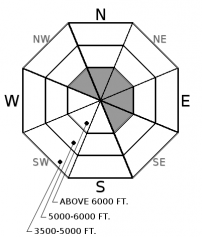
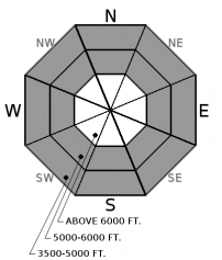
The avalanche danger is MODERATE at all elevations today. Temperatures have dropped below freezing above 6000 feet and 3-7 inches of snow overnight combined with west-southwest winds have likely formed fresh wind slabs. Below 6000 feet, wet loose avalanches remain possible thanks to the rain and above-freezing temperatures. Pay attention to changing conditions and evaluate the snowpack and your terrain choices carefully.

2. Moderate
?
Above 6500 ft.
2. Moderate
?
5000-6500 ft.
2. Moderate
?
3500-5000 ft.
- 1. Low
- 2. Moderate
- 3. Considerable
- 4. High
- 5. Extreme
-
Type ?
-
Aspect/Elevation ?

-
Likelihood ?CertainVery LikelyLikelyPossible
 Unlikely
 -
Size ?HistoricVery LargeLargeSmall

Wind slab avalanches are possible today in high-elevation terrain where it is cold enough for the snow to remain light and dry. Temperatures have dropped below freezing above 6000 feet and 3-5 inches of snow has fallen overnight in the Whitefish Range and southern Glacier Park. Noisy Basin in the Swan Range is reporting 7 inches of new snow. Another 1-2 inches are expected as the day goes on. West to southwest winds are blowing 5-20 mph with gusts reaching 20-25 mph in the Whitefish Range and 44 mph in southern Glacier Park. This is enough speed to transport dry snow and form wind slabs. Easterly aspects are more likely to be loaded today. But look for the tell-tale signs of wind slab such as smooth rounded pillows on the snow surface on all slopes, especially above 6000 feet. Cracks shooting out from under your skis or sled are a great indication of unstable snow and that wind-loaded slopes should be avoided.
-
Type ?
-
Aspect/Elevation ?

-
Likelihood ?CertainVery LikelyLikelyPossible
 Unlikely
 -
Size ?HistoricVery LargeLargeSmall

Wet loose avalanches are possible below 6000 feet where air temperatures are above freezing and precipitation is falling as rain or a rain/snow mix. These weather conditions have saturated the surface snow making wet loose activity more likely. Look for signs of instability associated with loose wet avalanches that include rollerballs, snow dropping out of trees, and recent wet loose sluffs on steep slopes. Beware of travelling through terrain traps such as in the bottom of narrow, steep-walled gullies where the consequences of small avalanches can be higher.
We have not observed or been informed of any avalanches occurring on the January 19th crust or any other persistent weak layer since late last week. However, in some places stability tests are still showing reactive results around the January 19 crust and, in isolated locations, the depth hoar at the base of the snowpack is reactive as well. Even though these layers have not produced any avalanches lately, it is still important to be aware that in some locations in the advisory area there is a poor snowpack structure with buried weak layers that may still be reactive. Because these weak layers do not always present obvious signs of instability, digging into the snowpack is the best way to determine their location and reactivity. Also you are more likely to find and/or trigger one of these weak layers in steep rocky terrain that typically has a more shallow snowpack.
We would like to thank all those who have been submitting observations recently. These observations are invaluable and improve our forecasts. Several observers have submitted reports from across the advisory area documenting the widespread avalanche activity from last week (see our Observations Page). Thank you!
Thursday: We were in the Whitefish Range east of Whitefish Mountain Resort (observation). Very foggy weather limited visibility but no recent avalanche activity was observed. Last week's rain crust was breaking down making for a little better skiing. Two snowpits, one a NNE aspect, and another on a SE aspect yielded no propagation on any layer and no fractures on the Jan 19th crust which was about 1 m below the surface. BNSF Avalanche Safety observed a few small wet loose avalanches in some of the terrain above the railroad in Southern Glacier Park.
Wednesday: Guy and Seth travelled to Red Meadow Lake in the Northern Swan Range where they found temperatures above freezing, variable surface snow conditions and evidence of natural avalanche cycle from the Frebruary 3-10 cycle. At least one of those avalanches ran on the January 19 crust (Avalanche Observation). We also received a public observation from Werner Peak that affirmed there is still instability associated with the January 19 crust (Snowpack Observation).
See below for all observations this season.
Temperatures have dropped below freezing this morning above 6000 feet and range from 25-31ºF. Overnight winds have been from the west - southwest averaging 4-24 mph with maximum gusts of 10-44 mph. Windier conditions exist near the Continental Divide in the eastern part of the advisory area. We can expect the precipitation to taper off as the day progress and temperatures will climb back up into the low to mid 30s ºF above 6000 feet and into the low 40s ºF at elevations below this. Light to moderate west-southwest winds will continue through the day.
| 0600 temperature: | 25 to 31 deg. F. |
| Max. temperature in the last 24 hours: | 32 to 42 deg. F. |
| Average wind direction during the last 24 hours: | west - southwest |
| Average wind speed during the last 24 hours: | 4-24 mph |
| Maximum wind gust in the last 24 hours: | 10-44 mph |
| New snowfall in the last 24 hours: | 3-7 inches |
| Total snow depth: | 78-97 inches |
This advisory applies only to backcountry areas outside established ski area boundaries. This advisory describes general avalanche conditions and local variations always occur. This advisory expires at midnight on the posted day unless otherwise noted. The information in this advisory is provided by the USDA Forest Service who is solely responsible for its content.


