| Sunday | Sunday Night | Monday | |
|---|---|---|---|
| Cloud Cover: | High pressure builds with light winds. | Clear and cool. | High pressure strengthens. |
| Temperatures: | 27-34 deg. F. | 10-20 deg. F. | 29-38 deg. F. |
| Wind Direction: | Southwest | West-southwest | South-southwest |
| Wind Speed: | 8-10 mph with gusts to 21 | 6-7 mph with gusts to 20 | 2-4 mph |
| Snowfall: | 0 in. | 0 in. | 0 in. |
| Snow Line: |
Whitefish Range
Swan Range
Flathead Range and Glacier National Park
How to read the forecast
Moderate to strong winds over the past 48 hours have formed fresh wind slabs, especially in the alpine. Storms over the past week have deposited a thick slab on top of a weak snowpack structure. The avalanche danger is CONSIDERABLE above 6000 feet. You are likely to trigger a wind slab avalanche today and it is possible to trigger an avalanche on a buried weak layer at all elevations. Conservative decision-making remains essential on all aspects.

3. Considerable
?
Above 6500 ft.
2. Moderate
?
5000-6500 ft.
2. Moderate
?
3500-5000 ft.
- 1. Low
- 2. Moderate
- 3. Considerable
- 4. High
- 5. Extreme
-
Type ?
-
Aspect/Elevation ?

-
Likelihood ?CertainVery LikelyLikelyPossible
 Unlikely
 -
Size ?HistoricVery LargeLargeSmall

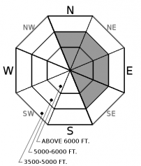
Over the past 48 hours most upper elevation weather stations have reported moderate to strong southwesterly winds with impressively strong gusts. At favored windy locations gusts have reached the 50-60 mph range! Despite the recent rain/wet snow event there is still snow available for transport, particularly in the alpine region above the rain line. Therefore, expect to find fresh wind slabs on typical leeward aspects. Due to the amount of new snow that we recently received some of these slabs may be 3+ feet thick. It is likely that you could trigger a wind slab avalanche today, particularly in the alpine.
-
Type ?
-
Aspect/Elevation ?

-
Likelihood ?CertainVery LikelyLikelyPossible
 Unlikely
 -
Size ?HistoricVery LargeLargeSmall

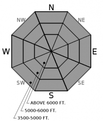
Prior to the recent storm cycle, our snowpack contained a variety of weak layers located at the bottom of the pack, mid-pack and near the surface. Recent heavy snowfall buried these weak layers an additional 2-4 feet. Some of the avalanche activity that occurred this week was associated with these weak layers, particularly the weak snow surrounding the January 19 crust. A weak snowpack structure exists across our area that is now capped by a thick surface slab. Whumfing sounds, or collapsing of the snow pack, while traveling across the snow is an obvious sign of instability.
Conditions at low and mid-elevation terrain have recently become a concern. The snow structure is weak and was not a problem before the last series of storms due to the lack of a cohesive slab. Now we have a thick slab above this layer. Pay attention to sneaky slopes, steep pitches, and cut banks well below the tree-line.
Ladies, are you interested in refreshing your avalanche knowledge or looking for a great introduction to avalanche safety? If so, join us at The White Room Mountain Shop, in Whitefish, on Thursday, February 16th at 6:30 pm for a free, engaging, and entertaining 1 hour avalanche awareness presentation. The class includes general information about avalanche hazard, how to avoid it, and proper equipment for traveling in avalanche terrain.
Saturday: FAC intern Zach was in the Ten Lakes region of the northern Whitefish Range where his group noted numerous avalanches from the recent storm cycle. They was also able to remotely trigger a hard slab avalanche from 100 yards on a layer of buried facets 2 feet below the snow surface and also experienced a large collapse during his tour. Skiers on Peak 6996, in southern Glacier Park, reported a supportable surface rain crust throughout their tour. This crust was 2-3" thick and pencil hard at upper elevations. Stability tests in their snowpit showed propagation at the January 19 crust. Active wind loading occurred during the day from the light snow that fell overnight.
Friday: Mark traveled in the backcountry east of the WMR ski area in the southern Whitefish Range. Numerous crowns from recent avalanche activity were noted on both north and south facing aspects. These avalanches occurred during both the February 4-6 storm and the February 8-9 storm. At upper elevations a dense 8 inches thick storm slab was resting on top of approximately 24 inches of recent low density snow.
Thursday: BNSF Avalanche Safety Team reported natural avalanche activity in John F. Stevens Canyon in southern Glacier Park. One large magnitude avalanche deposited 6-8 feet of debris that was 150 feet wide on the railway, and it also reached the highway. The powder blast from the avalanche was evident 25 feet up a power pole.
See below for all observations this season.
In the past 24 hours temperatures ranged from the low 20s to upper 20s with winds out of the southwest that averaged 10-36 mph with maximum gusts of 24-54 mph. Currently, temperatures above 6000 feet range from 17-23ºF, and winds are southwest at 7-18 mph with gusts from 13-30 mph. Today high pressure will continue to strengthen over our area and we should see continued breezy conditions with temperatures in the upper 20s to low 30s.
| 0600 temperature: | 14-20 deg. F. |
| Max. temperature in the last 24 hours: | 17-29 deg. F. |
| Average wind direction during the last 24 hours: | South-Southwest |
| Average wind speed during the last 24 hours: | 4-36 mph |
| Maximum wind gust in the last 24 hours: | 24-54 mph |
| New snowfall in the last 24 hours: | 0 inches |
| Total snow depth: | 71-105 inches |
This advisory applies only to backcountry areas outside established ski area boundaries. This advisory describes general avalanche conditions and local variations always occur. This advisory expires at midnight on the posted day unless otherwise noted. The information in this advisory is provided by the USDA Forest Service who is solely responsible for its content.


