| Monday | Monday Night | Tuesday | |
|---|---|---|---|
| Cloud Cover: | Partly cloudy. | Cool wet system enters our area. | Moderate to heavy snow. |
| Temperatures: | 26-36 deg. F. | 8-19 deg. F. | 18-26 deg. F. |
| Wind Direction: | west | west | northeast |
| Wind Speed: | 8-12 mph with gusts to 25 | 5-7 mph with gusts to 17 | 8-9 mph |
| Snowfall: | 0 in. | 1-5 in. | 2-9 in. |
| Snow Line: |
Whitefish Range
Swan Range
Flathead Range and Glacier National Park
How to read the forecast
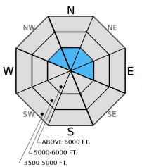
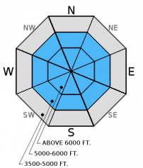
The avalanche danger is MODERATE above 6000 feet. Winds increased in speed overnight and continue to drift snow onto leeward aspects forming fresh wind slabs and adding weight to existing slabs. In some locations these slabs are being deposited on top of a rain crust. Evaluate all wind loaded terrain before recreating on it. Despite recent warm weather, weak layers exist and are a concern in our snowpack. Choose conservative terrain in areas where you find a weak snowpack structure.

2. Moderate
?
Above 6500 ft.
1. Low
?
5000-6500 ft.
1. Low
?
3500-5000 ft.
- 1. Low
- 2. Moderate
- 3. Considerable
- 4. High
- 5. Extreme
-
Type ?
-
Aspect/Elevation ?

-
Likelihood ?CertainVery LikelyLikelyPossible
 Unlikely
 -
Size ?HistoricVery LargeLargeSmall

Following an extended period of calm to light winds our area returned to an active windy pattern over the past 72 hours. An example of recent windy conditions is the Hornet Lookout, in the northern Whitefish Range, where overnight sustained winds reached 40 mph with gusts to 55! In favored windy locations expect to find recently scoured windward slopes which is an obvious clue that wind transported snow has occurred. Today, expect to find recently formed wind slabs in upper elevation locations across our area. Locations of fresh wind slab development will exhibit cracking in the surface snow. Areas of older wind slabs may not show these obvious signs and may be detected by hollow sounding snow and smooth rounded pillows. In some locations these slabs have been deposited on a rain crust which will make for a great sliding surface. Evaluate all wind loaded terrain before recreating on it.
-
Type ?
-
Aspect/Elevation ?

-
Likelihood ?CertainVery LikelyLikelyPossible
 Unlikely
 -
Size ?HistoricVery LargeLargeSmall

Weak layers formed throughout this season can still be found in our snowpack and remain a concern. These layers can be found at the bottom, middle and top of our pack. The near surface weak layers exist immediately below the January 19 crust and can be identified easily. The other weak layers take a bit more effort to identify and require that you dig into the snow to search them out. Where these layers are found conservative decision making is the solution. Avoid areas that are steep and rocky and/or have a shallow snowpack. These areas are where the deeper weak layers have been preserved.
Sunday's combination of above freezing air temperatures and abundant solar input moistened the surface snow on solar aspects at mid and upper elevations. This has resulted in a sun/melt freeze crust on the surface. Not only has this deteriorated the quality of the skiing/riding but this crust will be a potential sliding surface for the cool wet system that is moving into our area tonight. If you are out recreating today note the distribution and thickness of this layer.
Sunday: Mark was in the southern Whitefish Range where warm temperatures and abundant sunshine moistened the surface snow on solar aspects. At lower elevations we were able to initiate small wet loose slides on our descent. Near surface instability was noted in a facet layer below the January 19 crust and in a buried layer of facets one foot below the snow surface.
Saturday: Riders in the northern Swan Range felt a whumpf or collapse in the snowpack. They also noted surface snow sliding on the underlying hard layer along with minor cracking. Skiers in the southern Whitefish Range noted active wind transport of the surface low density snow. Skiers in Rescue Creek in the Flathead Range found fresh wind slabs with wind loaded ridges and breakable crust below 6200'. Skiers in the Missions, out of our forecast area, noted windy conditions in the upper elevations with southerly slopes heating up producing rollerballs and small point releases. Skiers in the Marion Lake area of the Flathead Range found a deep snowpack on a northwesterly aspect and noted a good size wet avalanche that had terminated on the hiking trail.
Friday: Guy and Mark traveled to the Red Meadow area of the northern Whitefish Range where they found the Jan 19 rain crust below 5600'. Above that elevation the rain crust was replaced by a 3" thick dense slab of snow that rested on an obvious thin layer of facets. During our ascent and descent this slab broke easily on the facets but did not propagate.
See below for all observations this season.
One last warm breezy day before the high pressure breaks down and a wet cool system moves into our area this evening. Above 6000 feet temperatures currently range from 22-31ºF, and winds are out of the southwest at 10-24 mph with gusts from 20-38 mph. Today should bring partly cloudy skies and temperatures in the upper 20s to low 30s. Winds will continue out of the west-southwest at 10-15 mph with gusts in the 30s.
| 0600 temperature: | 22-31 deg. F. |
| Max. temperature in the last 24 hours: | 34-40 deg. F. |
| Average wind direction during the last 24 hours: | southwest |
| Average wind speed during the last 24 hours: | 4-40 mph |
| Maximum wind gust in the last 24 hours: | 27-55 mph |
| New snowfall in the last 24 hours: | 0 inches |
| Total snow depth: | 53-69 inches |
This advisory applies only to backcountry areas outside established ski area boundaries. This advisory describes general avalanche conditions and local variations always occur. This advisory expires at midnight on the posted day unless otherwise noted. The information in this advisory is provided by the USDA Forest Service who is solely responsible for its content.


