| Saturday | Saturday Night | Sunday | |
|---|---|---|---|
| Cloud Cover: | Partly cloudy. | Partly cloudy. | Partly sunny. |
| Temperatures: | 27-35 deg. F. | 12-23 deg. F. | 29-40 deg. F. |
| Wind Direction: | west | southwest | southwest |
| Wind Speed: | 7-9 mph with gusts to 21 | 8-10 mph with gusts to 23 | 7-11 mph with gusts to 25 |
| Snowfall: | 0 in. | 0 in. | 0 in. |
| Snow Line: |
Whitefish Range
Swan Range
Flathead Range and Glacier National Park
How to read the forecast
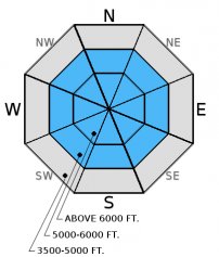
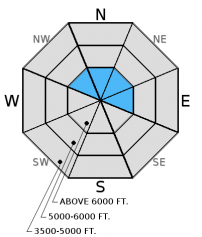
The avalanche danger is MODERATE above 6000 feet. Despite recent warm weather, weak layers continue to exist and be a concern in our snowpack. Choose less complex terrain in areas where you find a weak snowpack structure. Wind speeds have increased and are drifting recent low density snow onto leeward aspects forming thin wind slabs. In some locations these slabs are being deposited on top of a rain crust. Evaluate all wind loaded terrain before committing to it.

2. Moderate
?
Above 6500 ft.
1. Low
?
5000-6500 ft.
1. Low
?
3500-5000 ft.
- 1. Low
- 2. Moderate
- 3. Considerable
- 4. High
- 5. Extreme
-
Type ?
-
Aspect/Elevation ?

-
Likelihood ?CertainVery LikelyLikelyPossible
 Unlikely
 -
Size ?HistoricVery LargeLargeSmall

Up until January 18 our winter was unique in terms of below average temperatures and dry low density snow. This weather pattern produced a variety of weak layers in our snowpack. Recent weather has been more typical (warm and humid) and is slowly strengthening these layers. Weak layers formed earlier in the year remain a concern and should be looked for by digging into the snowpack. Where a poor structure exists, such as steep rocky areas and/or areas of shallow snow depth, choose less consequential terrain.
-
Type ?
-
Aspect/Elevation ?

-
Likelihood ?CertainVery LikelyLikelyPossible
 Unlikely
 -
Size ?HistoricVery LargeLargeSmall

Recent weak systems have deposited low density snow at upper elevations across our area. Reports from favored locations (Swan and Flathead Ranges) indicate up to 10" of new on top of the January 19 rain crust. Wind speeds yesterday and overnight were sufficient to drift this snow onto leeward aspects forming thin wind slabs. Continued breezy conditions today should help to develop these slabs. In some locations these slabs will be resting on a rain crust which will make for a great sliding surface. Evaluate all wind loaded terrain in the upper elevations before committing to it.
With warmer temperatures and a bit of sun forecast for the weekend be alert for isolated areas of loose snow avalanches. In favored locations up to 10" of recent low density snow has been deposited on top of a rain crust. Loose snow sliding on a smooth crust can pick up a good head of steam and be particularly consequential if traveling near terrain traps like cliffs, trees, and narrow gullies.
Friday: Guy and Mark traveled to the Red Meadow area of the northern Whitefish Range where they found the Jan 19 rain crust below 5600'. Above that elevation the rain crust was replaced by a 3" thick dense slab of snow that rested on an obvious thin layer of facets. During our ascent and descent this slab broke easily on the facets but did not propagate.
Thursday: Skiers were in the Marion Lake/ Dickey Ridge area in the Flathead Range. Above 6000 feet they found 8-9 inches of recent snow atop the supportable Jan. 19 crust. They did not observe any recent avalanche activity or obvious signs of instability.
Wednesday: A party of snow bikers was in the Lost Johnny drainage in the Swan Range and found 8 inches of snow on top of the Jan. 19 crust. They noted multiple small, loose snow avalanches sliding on that crust. They also noted thin, slabs that were reported as running fairly long. Skiers on Elk Mountain in southern Glacier National Park reported areas where 5-10 cm of recent snow easily sluffed on the Jan 19 crust. They also noted poor snow pack structure with several layers of weak (faceted) snow and depth hoar at the ground. In one of their Extended Column Tests the column failed on the depth hoar while isolating it.
Tuesday: Adam and Todd were on Elk Mountain in southern Glacier National Park and found the breakable Jan. 19 crust buried by only 2-3 cm of snow. Snow coverage was thin and sparse at upper elevations. In wind loaded areas the snow surface was very firm and supportable with poor structure below. They noted well developed depth hoar at the ground and a layer of weak facets 20 cm from the surface. A party of skiers toured Tunnel Creek to Mt. Liebig in the Flathead Range and found 2 inches of snow above the Jan. 19 crust below 6000 feet. Above 6000 feet conditions improved with additional snow on top of the supportable crust. They did not observe any recent avalanche activity or wind loading.
See below for all observations this season.
High pressure will slowly build over our area today and tomorrow. Above 6000 feet temperatures currently range from 15-24ºF, and winds are out of the southwest at 5-20 mph with gusts from 11-28 mph. We have received 0-3" of new snow with the Swan Range and the interior of Glacier Park being the favored locations. Today should bring partly cloudy skies and temperatures in the upper 20s to low 30s. Winds will continue out of the west at 5-15 mph with gusts in the upper 20s.
| 0600 temperature: | 15-24 deg. F. |
| Max. temperature in the last 24 hours: | 15-24 deg. F. |
| Average wind direction during the last 24 hours: | southwest |
| Average wind speed during the last 24 hours: | 5-20 mph |
| Maximum wind gust in the last 24 hours: | 16-28 mph |
| New snowfall in the last 24 hours: | 0-3 inches |
| Total snow depth: | 54-71 inches |
This advisory applies only to backcountry areas outside established ski area boundaries. This advisory describes general avalanche conditions and local variations always occur. This advisory expires at midnight on the posted day unless otherwise noted. The information in this advisory is provided by the USDA Forest Service who is solely responsible for its content.


