| Friday | Friday Night | Saturday | |
|---|---|---|---|
| Cloud Cover: | Partly cloudy, tapering showers early. | Partly cloudy. | Partly cloudy with cooler temps.. |
| Temperatures: | 27-36 deg. F. | 5-17 deg. F. | 24-31 deg. F. |
| Wind Direction: | South - Southwest | Southeast - Northeast | Northeast - South |
| Wind Speed: | 4-5 | 3-4 | 3-4 |
| Snowfall: | 0 in. | 0 in. | 0 in. |
| Snow Line: |
Whitefish Range
Swan Range
Flathead Range and Glacier National Park
How to read the forecast
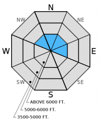
The cooler temperatures overnight helped to stabilize the surface snow, but weak layers lurk deeper in the snow pack. The avalanche danger is MODERATE above 5000 feet. Human triggered avalanches are possible particularly on steep, wind loaded slopes and terrain with shallow snow where it is easier to affect deeper instabilities. Dig into the snow to look for these weak, faceted layers and carefully assess recently wind loaded terrain before committing to it.

2. Moderate
?
Above 6500 ft.
2. Moderate
?
5000-6500 ft.
1. Low
?
3500-5000 ft.
- 1. Low
- 2. Moderate
- 3. Considerable
- 4. High
- 5. Extreme
-
Type ?
-
Aspect/Elevation ?

-
Likelihood ?CertainVery LikelyLikelyPossible
 Unlikely
 -
Size ?HistoricVery LargeLargeSmall

Wind speeds moderated in the past 24 hours but terrain that was loaded by the recent moderate to strong winds should be treated as suspect. Look for thick, smooth, and rounded pillows on the surface near ridgelines and terrain features that trap the wind drifted snow. Avoid steep, exposed slopes in the alpine that harbor these recent slabs. Also, keep in mind that even a small avalanche can trigger deeper instabilities resulting in a larger, more destructive slide.
-
Type ?
-
Aspect/Elevation ?

-
Likelihood ?CertainVery LikelyLikelyPossible
 Unlikely
 -
Size ?HistoricVery LargeLargeSmall

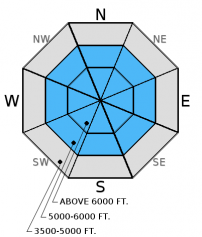
Multiple layers of weak, faceted snow exist in the mid and basal snow pack. The cold weather for the past month caused these layers to weaken even further. They have been mostly dormant this winter, but we have limited observations since the added stress of the recent storm. The only way to know if these layers exist beneath you is to dig into the snow and look for them. Where present avoid areas where you are more likely to trigger them like steep, rocky terrain.
In most locations surface hoar formed early in the week. A lot of it was likely destroyed by wind and rain, but in some locations it remains preserved beneath a thin layer of recent snow. It would be a good idea to pay attention to where this layer exists as it could become a problem in the future with additional snow and slab formation above.
We are deeply saddened to report that a skier sustained fatal injuries in an avalanche accident on Stanton Mountain in Glacier National Park Thursday, 01/05/2017. We extend our most sincere condolences to the family and friends. FAC staff, along with Glacier National Park Rangers, visited the site. The final report is complete and located here: http://www.flatheadavalanche.org/sites/default/files/20170105avalanchein...
Temperatures should be close to the freezing mark today and with some sun expected the potential to trigger loose, wet avalanches will remain particularly in low elevations. With the weak, shallow snow pack at low elevations these can entrain quite a bit of snow and be dangerous even on short, steep pitches that end in narrow gullies.
Tuesday: Seth was in the Flathead Range on Scalplock Mountain above Essex in GNP. where he observed no obvious signs of instability and little results in stability tests on NE and SE aspects. Poor structure to the snow pack with considerable depth hoar and other weak layers in the snow pack and widespread, sometimes very large surface hoar.
Monday: Guy was the Wahoo drainage in the Flathead Range. He noted the wind loading above treeline and the abundant surface hoar on shady aspects. In a snowpit on a south aspect at 6200 feet he observed a layer of weak faceted snow beneath an 18 inch wind slab (observation). Skiers in the Apgars found layers of weak faceted snow in the upper 14 inches of the snow pack. They also found extensive surface hoar growth on all aspects and elevations and noted a large avalanche on a distant peak that ran on a previous day.
See below for all observations this season.
Yesterday saw mild temperatures and brief light showers that produced at most 0.1 inches of water. As of 5:00 a.m. temperatures above 6000 feet cooled off a bit and range from 18-27º F. Wind speeds are currently out of the southwest at 5-18 mph with gusts from 12-20 mph. For today, expect partly cloudy skies with slightly cooler temperatures. Winds will shift out of the south and southeast at 5-10 mph with gusts in the low 20s. Light snow returns to the area late tomorrow.
| 0600 temperature: | 18-27 deg. F. |
| Max. temperature in the last 24 hours: | 27-33 deg. F. |
| Average wind direction during the last 24 hours: | southwest |
| Average wind speed during the last 24 hours: | 5-15 mph |
| Maximum wind gust in the last 24 hours: | 17-35 mph |
| New snowfall in the last 24 hours: | 0-1 inches |
| Total snow depth: | 51-70 inches |
This advisory applies only to backcountry areas outside established ski area boundaries. This advisory describes general avalanche conditions and local variations always occur. This advisory expires at midnight on the posted day unless otherwise noted. The information in this advisory is provided by the USDA Forest Service who is solely responsible for its content.


