| Thursday | Thursday Night | Friday | |
|---|---|---|---|
| Cloud Cover: | Warm with light snow/rain showers. | Mostly cloudy. | Partly cloudy with cooler temps.. |
| Temperatures: | 29-39 deg. F. | 15-23 deg. F. | 25-33 deg. F. |
| Wind Direction: | Southwest | Southwest | South - southwest |
| Wind Speed: | 7-11 gusts 20-25 | 6-10 gusts 21 | 4-5 |
| Snowfall: | 0-1 in. | 0-1 in. | 0 in. |
| Snow Line: |
Whitefish Range
Swan Range
Flathead Range and Glacier National Park
How to read the forecast
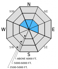
The latest system brought about rapid change to the snow pack with added water weight, wind transported snow, and warming temperatures. Dangerous conditions exist in the upper elevations. The avalanche danger is CONSIDERABLE above 6000 feet. Carefully evaluate the snow pack and choose conservative terrain while it adjusts to the recent stress.

3. Considerable
?
Above 6500 ft.
2. Moderate
?
5000-6500 ft.
2. Moderate
?
3500-5000 ft.
- 1. Low
- 2. Moderate
- 3. Considerable
- 4. High
- 5. Extreme
-
Type ?
-
Aspect/Elevation ?

-
Likelihood ?CertainVery LikelyLikelyPossible
 Unlikely
 -
Size ?HistoricVery LargeLargeSmall

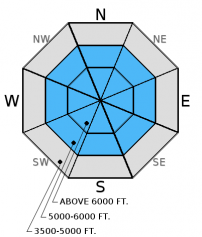
Moderate to strong winds continue to drift the storm snow and form slabs on leeward ridges particularly in exposed terrain in the alpine. In some locations these relatively heavy slabs were formed on a weak foundation making them especially sensitive. Stick to more sheltered terrain if traveling in the upper the elevations today. Identify wind loaded terrain by looking for thick, smooth, and rounded pillows on the surface along leeward ridgelines, rock outcrops, and spur ridges.
-
Type ?
-
Aspect/Elevation ?

-
Likelihood ?CertainVery LikelyLikelyPossible
 Unlikely
 -
Size ?HistoricVery LargeLargeSmall

Warm temperatures will aid in slab formation above and the additional water weight will continue to stress multiple weak layers in the mid and basal snow pack. The cold weather so far this month caused these layers to weaken even further. We have observed few avalanches associated with these layers this winter, but they could become more reactive with the additional load. The only way to know if these layers exist beneath you is to dig into the snow and look for them. Where present avoid areas where you are more likely to trigger them like steep, rocky terrain.
Surface hoar formed early in the week was hopefully destroyed by rain in lower and mid-elevations. Where this layer is preserved it should be shallow enough to not pose a problem today. But it is a good time to note the distibution of recently buried surface hoar as it has the potential to be problematic in the future as snow accumulates and slab develops above it.
-
Type ?
-
Aspect/Elevation ?

-
Likelihood ?CertainVery LikelyLikelyPossible
 Unlikely
 -
Size ?HistoricVery LargeLargeSmall

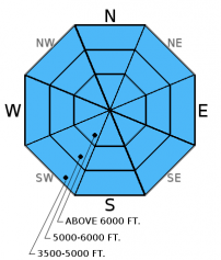
In most locations temperatures struggled to return to freezing overnight and will warm again today. The potential to trigger loose, wet avalanches will remain with bit of additional rain/heavy snow in the forecast. Remember that even small, loose, wet avalanches can have big consequence in terrain traps like narrow gullies, near cliffs, and trees.
We are deeply saddened to report that a skier sustained fatal injuries in an avalanche accident on Stanton Mountain in Glacier National Park Thursday, 01/05/2017. We extend our most sincere condolences to the family and friends. FAC staff, along with Glacier National Park Rangers, visited the site. The final report is complete and located here: http://www.flatheadavalanche.org/sites/default/files/20170105avalanchein...
Tuesday: Seth was in the Flathead Range on Scalplock Mountain above Essex in GNP. where he observced no obvious signs of instability and little results in stability tests on NE and SE aspects. Poor structure to the snowpack with considerable depth hoar and other weak layers in the snowpack and widespread, sometimes very large surface hoar.
Monday: Guy was the Wahoo drainage in the Flathead Range. He noted the wind loading above treeline and the abundant surface hoar on shady aspects. In a snowpit on a south aspect at 6200 feet he observed a layer of weak faceted snow beneath an 18 inch wind slab (observation). Skiers in the Apgars found layers of weak faceted snow in the upper 14 inches of the snowpack. They also found extensive surface hoar growth on all aspects and elevations and noted a large avalanche on a distant peak that ran on a previous day.
Sunday: Seth and Mark were in Canyon Creek teaching an avalanche class with Flathead County Search and Rescue. They noted surface hoar formation on all aspects and elevations. Loose snow slides on upper elevation steep southerly avalanche paths were initiated in the afternoon due to solar warming (observation). Riders in the Blacktail Mountain area noted surface hoar 1-2 cm in size. Skiers in the Flathead Range noted the growth of large surface hoar crystals above 6000 feet on north and northeastern aspects.
See below for all observations this season.
In the past 24 hours we picked up 0.5-0.7 inches of water which only translated to about 3 inches of heavy, wet snow. Temperatures warmed yesterday and remain relatively warm this morning ranging from 28-33º F. Winds are currently 8-13 mph with gusts from 14-34 mph out of the southwest. Today should see light showers with mountain temperatures warming to just above freezing in most locations. Winds will continue out of the southwest at 5-15 mph with gusts from 25-30 mph. Cooler and dryer air pushes into the region late afternoon/early evening.
| 0600 temperature: | 28-33 deg. F. |
| Max. temperature in the last 24 hours: | 30-35 deg. F. |
| Average wind direction during the last 24 hours: | southwest |
| Average wind speed during the last 24 hours: | 5-15 mph |
| Maximum wind gust in the last 24 hours: | 20-35 mph |
| New snowfall in the last 24 hours: | 0-3 inches |
| Total snow depth: | 52-71 inches |
This advisory applies only to backcountry areas outside established ski area boundaries. This advisory describes general avalanche conditions and local variations always occur. This advisory expires at midnight on the posted day unless otherwise noted. The information in this advisory is provided by the USDA Forest Service who is solely responsible for its content.


