| Tuesday | Tuesday Night | Wednesday | |
|---|---|---|---|
| Cloud Cover: | Mostly cloudy and continued warming. | Mostly cloudy chance of snow and/or freezing rain. | Light snow and/or rain. |
| Temperatures: | 25 to 37 deg. F. | 18 to 29 deg. F. | 31 to 39 deg. F. |
| Wind Direction: | southwest | southwest | south to southwest |
| Wind Speed: | 12-15 mph gusts to 45 | 13-17 mph gusts to 48 | 13-16 mph gusts to 37 |
| Snowfall: | 0 in. | 1 in. | 1-2 in. |
| Snow Line: |
Whitefish Range
Swan Range
Flathead Range and Glacier National Park
How to read the forecast
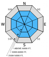
Southwest winds have increased overnight likely forming fresh wind slabs. Older wind slabs have been slow to strengthen. Weak layers formed earlier in the season have continued to weaken and remain a concern. The avalanche danger is MODERATE above 5000 feet. Carefully evaluate the snowpack and your terrain choices. Pay close attention to the changing weather today and be aware that quickly warming temperatures may increase the avalanche danger.

2. Moderate
?
Above 6500 ft.
2. Moderate
?
5000-6500 ft.
1. Low
?
3500-5000 ft.
- 1. Low
- 2. Moderate
- 3. Considerable
- 4. High
- 5. Extreme
-
Type ?
-
Aspect/Elevation ?

-
Likelihood ?CertainVery LikelyLikelyPossible
 Unlikely
 -
Size ?HistoricVery LargeLargeSmall

Over the last week the surface snow has mostly remained light and easily available for wind transport. South-southwest winds continue to drift this snow onto leeward aspects at upper elevations forming wind slabs. Warming temperatures will aid in the formation of these slabs, which in many locations are being deposited onto weak layers of old snow. Carefully assess wind loaded terrain before committing to it and keep in mind the potential for small avalanches to stress deeper weak layers resulting in larger avalanches. Wind loaded slopes are easily identified by looking for smooth, rounded pillows on the surface.
-
Type ?
-
Aspect/Elevation ?

-
Likelihood ?CertainVery LikelyLikelyPossible
 Unlikely
 -
Size ?HistoricVery LargeLargeSmall

Multiple weak layers have formed at various depths in our snowpack this season. Unfortunately the consistently cold weather over the past week has caused these layers to weaken even further. We have not observed many persistent slab avalanches this winter. But, be aware that quickly warming temperatures could start to make some of these weak layers more reactive. Look for these layers when you dig into the snow and avoid areas where you are more likely to trigger a persistent slab avalanche like steep, rocky terrain that may harbor a shallower snowpack.
We are deeply saddened to report that a skier sustained fatal injuries in an avalanche accident on Stanton Mountain in Glacier National Park Thursday, 01/05/2017. We extend our most sincere condolences to the family and friends. FAC staff, along with Glacier National Park Rangers, visited the site. The final report is complete and located here: http://www.flatheadavalanche.org/sites/default/files/20170105avalanchein...
Monday: Guy was the Wahoo drainage in the Flathead Range. He noted the wind loading above treeline and the abundant surface hoar on shady aspects. In a snowpit on a south aspect at 6200 feet he observed a layer of weak faceted snow beneath an 18 inch wind slab (observation). Skiers in the Apgars found layers of weak faceted snow in the upper 14 inches of the snowpack. They also found extensive surface hoar growth on all aspects and elevations and noted a large avalanche on a distant peak that ran on a previous day.
Sunday: Seth and Mark were in Canyon Creek teaching an avalanche class with Flathead County Search and Rescue. They noted surface hoar formation on all aspects and elevations. Loose snow slides on upper elevation steep southerly avalanche paths were initiated in the afternoon due to solar warming (observation). Riders in the Blacktail Mountain area noted surface hoar 1-2 cm in size. Skiers in the Flathead Range noted the growth of large surface hoar crystals above 6000 feet on north and northeastern aspects.
Saturday: Skiers on Sub Shields in southern Glacier Park observed surface hoar above 5000' in sheltered areas. They also noted wind loading on easterly aspects in the alpine. Riders in the northern Swan Range did not observe surface hoar development.
See below for all observations this season.
Temperatures are inverted this morning with cold air pooled in the valleys and warmer air aloft. Above 6000 feet temperatures range from 19 to 28 °F and winds are 6-25 mph, gusting to 23-38 mph out of the southwest. Temperatures are expected to rise into the mid to upper thirties later today with increasing southwest winds, especially near the Continental Divide. No new snow is expected. Tonight into tomorrow, the warming trend will continue and a mix of snow and/or freezing rain is possible.
| 0600 temperature: | 19 to 28 deg. F. |
| Max. temperature in the last 24 hours: | 23 to 28 deg. F. |
| Average wind direction during the last 24 hours: | southwest |
| Average wind speed during the last 24 hours: | 6-25 mph |
| Maximum wind gust in the last 24 hours: | 23-38 mph |
| New snowfall in the last 24 hours: | 0 inches |
| Total snow depth: | 51-70 inches |
This advisory applies only to backcountry areas outside established ski area boundaries. This advisory describes general avalanche conditions and local variations always occur. This advisory expires at midnight on the posted day unless otherwise noted. The information in this advisory is provided by the USDA Forest Service who is solely responsible for its content.


