| Monday | Monday Night | Tuesday | |
|---|---|---|---|
| Cloud Cover: | Partly cloudy and continued warming. | Cloudy and warmer. | Warm moist system enters our area later in the day. |
| Temperatures: | 18-27 deg. F. | 9-21 deg. F. | 28-38 deg. F. |
| Wind Direction: | Southwest | Southwest | South-Southwest |
| Wind Speed: | 6-7 mph with gusts to 29 | 11-16 mph with gusts to 33 | 13-18 mph gusts to 38 |
| Snowfall: | 0 in. | 0 in. | 1-2 in. |
| Snow Line: |
Whitefish Range
Swan Range
Flathead Range and Glacier National Park
How to read the forecast
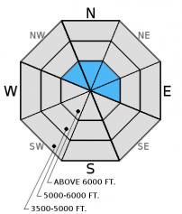
Above 5000 feet, the avalanche danger is MODERATE and human triggered avalanches are possible. At upper elevation locations fresh wind slabs continue to form and older wind slabs have been slow to strengthen. Carefully evaluate wind loaded terrain before committing to a slope. Weak layers exist throughout our pack and remain a concern. Avoid steep, rocky terrain and slopes with a shallow snow pack.

2. Moderate
?
Above 6500 ft.
2. Moderate
?
5000-6500 ft.
1. Low
?
3500-5000 ft.
- 1. Low
- 2. Moderate
- 3. Considerable
- 4. High
- 5. Extreme
-
Type ?
-
Aspect/Elevation ?

-
Likelihood ?CertainVery LikelyLikelyPossible
 Unlikely
 -
Size ?HistoricVery LargeLargeSmall

Our areas last snowfall was one week ago today. However, cold temperatures have preserved and even dried out this surface layer keeping it available for wind transport. West-southwesterly winds continue to drift this snow onto leeward aspects at upper elevation locations and warming temperatures have contributed to this fresh slab formation. These slabs are being deposited onto a layer of cold dry surface snow creating a potentially unstable situation. Carefully assess wind loaded terrain before committing to it and keep in mind the potential for small avalanches to stress deeper weak layers resulting in deeper slides. Wind loaded slopes are easily identified by looking for smooth, rounded features on the surface.
-
Type ?
-
Aspect/Elevation ?

-
Likelihood ?CertainVery LikelyLikelyPossible
 Unlikely
 -
Size ?HistoricVery LargeLargeSmall

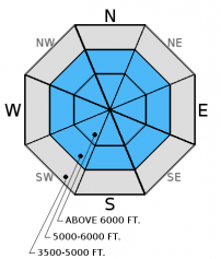
Weak layers that formed earlier this season continue to weaken due to the on going cold weather. These layers have not produced many natural avalanches this winter due to the relatively light loads that have been deposited onto the snow surface. However, in areas where a slab exists above these weak layers a human triggered avalanche is possible. Look for these layers when you dig in the snow and avoid areas where you are more likely to trigger a deeper avalanche like steep, shallow, rocky areas.
We are deeply saddened to report that a skier sustained fatal injuries in an avalanche accident on Stanton Mountain in Glacier National Park Thursday, 01/05/2017. We extend our most sincere condolences to the family and friends. FAC staff, along with Glacier National Park Rangers, visited the site. The final report is complete and located here: http://www.flatheadavalanche.org/sites/default/files/20170105avalanchein...
Sunday: Seth and Mark were in Canyon Creek teaching an avalanche class with Flathead County Search and Rescue. We noted surface hoar formation on all aspects and elevations. Loose snow slides on upper elevation steep southerly avalanche paths were initiated in the afternoon due to solar warming (observation). Riders in the Blacktail Mountain area noted surface hoar 1-2 cm in size.
Saturday: Skiers on Sub Shields in southern Glacier Park observed surface hoar above 5000' in sheltered areas. They also noted wind loading on easterly aspects in the alpine. Riders in the northern Swan Range did not observe surface hoar development.
Friday: Mark and Guy traveled to the Red Meadow area of the northern Whitefish Range. Once above the inversion (approximately 6000') they found widespread surface hoar on all aspects. At the snow surface, 8-10" of recent snow was found to be resting on decomposing surface hoar on a northerly aspect. The basal layer of the pack consisted of depth hoar. Erich was in the southern Whitefish Range were he noted a small skier/rider triggered wind slab avalanche that occurred during the day on a southerly aspect. Skiers in the Apgar Range in Glacier Park observed failures in the top 2 feet of new snow in their stability tests. They also noted a recent small slab avalanche.
See below for all observations this season.
Yesterday, strong valley inversions lasted throughout the day with relatively warm bluebird conditions at mid and upper elevations. Currently temperatures above 6000 range from 11-20º F , and winds are 7-16 mph gusting to 17-20 mph out of the southwest. Temperatures are expected to rise to the upper-twenties, and winds will remain out of the west - southwest at at 5-10 mph with gusts to 23 mph.
| 0600 temperature: | 11-20 deg. F. |
| Max. temperature in the last 24 hours: | 17-25 deg. F. |
| Average wind direction during the last 24 hours: | southwest |
| Average wind speed during the last 24 hours: | 3-18 mph |
| Maximum wind gust in the last 24 hours: | 21-26 mph |
| New snowfall in the last 24 hours: | 0 inches |
| Total snow depth: | 52-72 inches |
This advisory applies only to backcountry areas outside established ski area boundaries. This advisory describes general avalanche conditions and local variations always occur. This advisory expires at midnight on the posted day unless otherwise noted. The information in this advisory is provided by the USDA Forest Service who is solely responsible for its content.


