| Saturday | Saturday Night | Sunday | |
|---|---|---|---|
| Cloud Cover: | Partly cloudy and warming temps. | Cold and clear. | Mostly clear and cool. |
| Temperatures: | 18-33 deg. F. | 1-12 deg. F. | 17-26 deg. F. |
| Wind Direction: | West | Southwest-West | Southwest |
| Wind Speed: | 4-6 mp | 4-8 mph gusts to 21 | 4-7 mph gusts to 20 |
| Snowfall: | 0 in. | 0 in. | 0 in. |
| Snow Line: |
Whitefish Range
Swan Range
Flathead Range and Glacier National Park
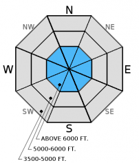
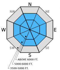
How to read the forecast
Above 5000 feet, the avalanche danger is MODERATE and human triggered avalanches are possible. Recent winds have drifted snow onto a variety of aspects forming thin wind slabs. Carefully evaluate wind loaded terrain before committing to a slope. Weak layers formed earlier in the season continue to weaken and remain a concern. Avoid steep, rocky terrain and slopes with a shallow snow pack.

2. Moderate
?
Above 6500 ft.
2. Moderate
?
5000-6500 ft.
1. Low
?
3500-5000 ft.
- 1. Low
- 2. Moderate
- 3. Considerable
- 4. High
- 5. Extreme
-
Type ?
-
Aspect/Elevation ?

-
Likelihood ?CertainVery LikelyLikelyPossible
 Unlikely
 -
Size ?HistoricVery LargeLargeSmall

Our continued cold weather has helped to preserve soft snow for great recreating but it has also contributed to a very slow strengthening of recently deposited wind slabs. An example of this was the small skier/rider triggered wind slab avalanche that Erich observed in the southern Whitefish Range yesterday (observation). Given the variable surfaces that these slabs were formed on continue to carefully assess wind loaded terrain before committing to it. Also, keep in mind the potential for small avalanches to stress deeper weak layers resulting in deeper slides. Wind loaded slopes are easily identified by looking for smooth, rounded features on the surface.
-
Type ?
-
Aspect/Elevation ?

-
Likelihood ?CertainVery LikelyLikelyPossible
 Unlikely
 -
Size ?HistoricVery LargeLargeSmall

So far, our January weather has been relatively cold and dry which has contributed to the further weakening of our snowpack. Weak layers that were formed in December continue to deteriorate due to the significant temperature gradient in our pack. At the bottom of the pack this layer is relatively thick and resembles table sugar. In the mid pack you may find several thin soft layers sandwiched by harder layers. Look for these layers when you dig in the snow and avoid areas where you are more likely to trigger a deeper avalanche like steep, shallow, rocky areas.
We are deeply saddened to report that a skier sustained fatal injuries in an avalanche accident on Stanton Mountain in Glacier National Park Thursday, 01/05/2017. We extend our most sincere condolences to the family and friends. FAC staff, along with Glacier National Park Rangers, vistited the site on Friday. We will provide a complete report of their findings within a few days.
Friday: Mark and Guy traveled to the Red Meadow area of the northern Whitefish Range. Once above the inversion (approximately 6000') they found widespread surface hoar on all aspects. At the snow surface, 8-10" of recent snow was found to be resting on decomposing surface hoar. The basal layer of the pack consisted of depth hoar. Erich was in the southern Whitefish Range were he noted a small skier/rider triggered wind slab avalanche that occurred during the day on a southerly aspect. Skiers in the Apgar Range in Glacier Park observed failures in the top 2 feet of new snow in their stability tests. They also noted a recent small slab avalanche.
Thursday: Skiers on Snowshed Mountain in the Flathead Range reported 2 natural wind slab avalanches at upper elevations.
Wednesday, BNSF Avalanche Safety reported recent avalanche activity in the John F Stevens Canyon in wind loaded terrain. Recent storm slab avalanche activity was reported in an area known as Dorothy's in the southern Whitefish Range. We were in the Cascade Creek drainage in the Flathead Range and found remnant crown lines from storm slabs that released earlier in the week. Wind was calm in this area and we could only see minimal drifting on surrounding peaks.Also on Wednesday, skiers were on Sub-Shields in the Lewis Range of Glacier National Park they found generally unconsolidated surface snow, atypical wind loading patterns, and evidence of recent cornice fall. They noted weak snow deep in the snow pack that was minimally reactive in stability tests.
Tuesday: Seth traveled to Kimmerly Basin and found 6 to 10 inches of new snow from the Sunday/Monday storm. Winds from the southwest were actively transporting snow on exposed slopes. A shallow snowpack with depth hoar, but little reaction in stability tests was found on a sw aspect while a much deeper, wind loaded snowpack was found on an east aspect. One to two feet of new and wind loaded snow was on top of a weaker layer of snow that fell on Saturday night. This layer failed and propagated with moderate to hard force and we suspect this is the same layer that failed in the natural avalanche that occurred adjacent to the pit location while we were in the pit.
See below for all observations this season.
Valley inversions remained strong but temperatures warmed a bit at all elevations yesterday. Currently temperatures above 6000 range from 5-15º F , and winds are 2-8 mph gusting to 9-18 mph out of the southwest. Temperatures are expected to rise to the mid-twenties, and winds will remain out of the west - southwest at at 5-10 mph with gusts to 20 mph.
| 0600 temperature: | 5-15 deg. F. |
| Max. temperature in the last 24 hours: | 14-20 deg. F. |
| Average wind direction during the last 24 hours: | southwest |
| Average wind speed during the last 24 hours: | 3-13 mph |
| Maximum wind gust in the last 24 hours: | 15-25 mph |
| New snowfall in the last 24 hours: | 0 inches |
| Total snow depth: | 53-72 inches |
This advisory applies only to backcountry areas outside established ski area boundaries. This advisory describes general avalanche conditions and local variations always occur. This advisory expires at midnight on the posted day unless otherwise noted. The information in this advisory is provided by the USDA Forest Service who is solely responsible for its content.


