| Monday | Monday Night | Tuesday | |
|---|---|---|---|
| Cloud Cover: | Moderate snow with gusty SW winds. | Light snow with cooling temperatures. | Light snow with cool temperatures. |
| Temperatures: | 20-29 deg. F. | 6-17 deg. F. | 12-24 deg. F. |
| Wind Direction: | Southwest | Southwest | West |
| Wind Speed: | 10-12 mph with gusts to 25 | 11 mph with gusts to 24 | 8-10 mph |
| Snowfall: | 6-10 in. | 2-5 in. | 2-6 in. |
| Snow Line: |
Whitefish Range
Swan Range
Flathead Range and Glacier National Park
How to read the forecast
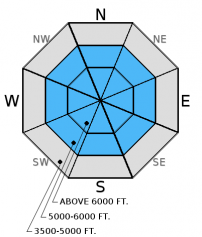
Dangerous avalanche conditions exist and human triggered avalanches are likely today. Warm heavy snow, accompanied by wind, is being deposited onto a cold low density snow surface. Avalanches today could step down into deeper weak layers. This morning the avalanche danger is CONSIDERABLE above 5000' but may rise throughout the day with continued snow and wind. Conservative decision making is essential.

3. Considerable
?
Above 6500 ft.
3. Considerable
?
5000-6500 ft.
2. Moderate
?
3500-5000 ft.
- 1. Low
- 2. Moderate
- 3. Considerable
- 4. High
- 5. Extreme
-
Type ?
-
Aspect/Elevation ?

-
Likelihood ?CertainVery LikelyLikelyPossible
 Unlikely
 -
Size ?HistoricVery LargeLargeSmall

Today, we have all the ingredients we need for fresh storm slab development. Warm dense snow has fallen overnight, and will continue to fall throughout the day, onto a cold low density snow surface. This will result in a classic "upside down" snowpack. This warm snow will not bond well with the underlying cold snow and it is likely that you could trigger an avalanche in the storm snow today. Also, keep in mind that even a small avalanche can put rapid stress on the underlying snow pack and step down to deeper weak layers. Look for obvious signs of instability like cracking in the snow surface. You may also hear whumpfing sounds which tells you that the underlying low density snow is collapsing and can not support this new load.
-
Type ?
-
Aspect/Elevation ?

-
Likelihood ?CertainVery LikelyLikelyPossible
 Unlikely
 -
Size ?HistoricVery LargeLargeSmall

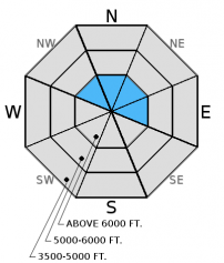
Light winds, with moderate to strong gusts, will drift new snow onto leeward aspects. In many locations these new dense slabs will be deposited onto a low density snow surface. In some areas leeward slopes were scoured by last weeks northeast winds and weakened by the cold weather making them capable of producing deeper avalanches than expected. It is likely that you could trigger a wind slab avalanche today and all wind loaded terrain should be viewed with suspicion. Look for smooth rounded pillows near ridgelines and around cross loaded features. Cracking in the snow surface is an obvious sign that these slopes should be avoided.
-
Type ?
-
Aspect/Elevation ?

-
Likelihood ?CertainVery LikelyLikelyPossible
 Unlikely
 -
Size ?HistoricVery LargeLargeSmall

Our snowpack is not the strong northwest Montana snowpack that we are used to. Instead it is actually quite weak. We have seen limited avalanches on deeper weak layers in the pack this season because this seasons weather pattern has not tested it. Today's heavy snow load will be a good test of these layers strength. We do not know the load that these deeper weak layers can handle so conservative decision making is essential.
We are deeply saddened to report that a skier sustained fatal injuries in an avalanche accident on Stanton Mountain in Glacier National Park Thursday, 01/05/2017. We extend our most sincere condolences to the family and friends. FAC staff, along with Glacier National Park Rangers, vistited the site on Friday. We will provide a complete report of their findings within a few days.
Join us on Friday, January 13 at The Stonefly Lounge, in Coram, at 7:00 pm for a free, engaging, and entertaining 1 hour avalanche awareness presentation.
Sunday: Riders in South Canyon of the southern Whitefish Range observed firm snow at low elevations but a soft snow surface at mid and upper elevations.
Friday: Mark and 2 Glacier National Park Rangers visited Mt. Stanton in GNP. They found a relatively shallow snowpack with weak snow at the ground at mid and upper elevations. Wind slabs formed during the New Year's Day arctic intrusion were also noted. BNSF Avalanche Safety toured in John F. Stevens Canyon and observed a variety of wind slabs at mid and upper elevations. Shooting cracks in the surface slab were noted in isolated locations. Depth hoar was found at the bottom of the pack and had developed into larger grains than what was last viewed in this location 2 weeks ago.
Thursday, Zach was in the Crystal Drainage in the Flathead Range. He found wind affected snow above 6000' that was minimally reactive in stability tests. He also noted facets developing in the upper snowpack at all elevations. He observed wind transporting snow on the surrounding high peaks.
See below for all observations this season.
A warm moist air mass moved into our region Sunday evening which has resulted in rising temperatures at upper elevation locations. Currently, mountain temperatures range from 21-32ºF, and winds are out of the southwest at 1-9 mph with gusts from 17-22 mph. Snow totals are a bit skewed this morning due to heavy snow falling onto a low density snow surface resulting in settlement at the snow surface. We have received 3-6+" of new snow.
| 0600 temperature: | 21-32 deg. F. |
| Max. temperature in the last 24 hours: | 22-32 deg. F. |
| Average wind direction during the last 24 hours: | SW |
| Average wind speed during the last 24 hours: | 5-10 mph |
| Maximum wind gust in the last 24 hours: | 11-22 mph |
| New snowfall in the last 24 hours: | 3-6 inches |
| Total snow depth: | 49-66 inches |
This advisory applies only to backcountry areas outside established ski area boundaries. This advisory describes general avalanche conditions and local variations always occur. This advisory expires at midnight on the posted day unless otherwise noted. The information in this advisory is provided by the USDA Forest Service who is solely responsible for its content.


