| Sunday | Sunday Night | Monday | |
|---|---|---|---|
| Cloud Cover: | Increasing temps with light snow. | Moderate to heavy snow with windy conditions. | Light snow continues. |
| Temperatures: | 18-30 deg. F. | 14-23 deg. F. | 20-29 deg. F. |
| Wind Direction: | South-Southwest | South | Southwest |
| Wind Speed: | 4-5 mph | 6-7 mph with gusts to 21 | 8-10 mph with gusts to 23 |
| Snowfall: | 0-1 in. | 4-8 in. | 2-6 in. |
| Snow Line: |
Whitefish Range
Swan Range
Flathead Range and Glacier National Park
How to read the forecast
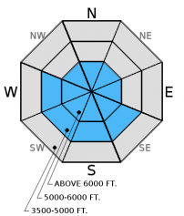
Several generations of wind slabs exist at mid and upper elevations throughout our area. Recent cold temperatures has delayed the strengthening process for these slabs and contributed to the weakening of the snowpack below these slabs. The avalanche danger is MODERATE above 5000 feet where human triggered avalanches are possible. Carefully evaluate wind loaded slopes and keep in mind the potential for a small avalanche to step down in to deeper weak layers.

2. Moderate
?
Above 6500 ft.
2. Moderate
?
5000-6500 ft.
1. Low
?
3500-5000 ft.
- 1. Low
- 2. Moderate
- 3. Considerable
- 4. High
- 5. Extreme
-
Type ?
-
Aspect/Elevation ?

-
Likelihood ?CertainVery LikelyLikelyPossible
 Unlikely
 -
Size ?HistoricVery LargeLargeSmall

Light snow overnight and through this morning, combined with light southwesterly winds, will form thin wind slabs on upper elevation leeward slopes. These fresh slabs should be easy to detect and manage. However, we have a variety of wind slabs formed over the past week which are more complex in their management. Earlier this week moderate to strong north-east winds created slabs on atypical slopes at mid and upper elevations. The recent avalanche fatality on Mt. Stanton involved a wind slab that was formed by these atypical winds (observation). In the past week we found hard slabs in upper elevations that fractured and propagated with easy force in stability tests (video 1, video 2). Remember, that even a small wind slab release can trigger deeper instabilities and produce a large avalanche. Though the obvious signs of instability like cracking and collapsing may not be present it is still important to carefully evaluate wind loaded terrain before committing to a slope.
-
Type ?
-
Aspect/Elevation ?

-
Likelihood ?CertainVery LikelyLikelyPossible
 Unlikely
 -
Size ?HistoricVery LargeLargeSmall

The month of December brought our area a bounty of low density snowfall which, unfortunately, can deteriorate when subjected to cold temperatures. The well below normal temperatures over the past 7 days has further exacerbated this problem. In areas with a shallow snowpack, depth hoar can be found at the ground. BNSF Avalanche Safety noted increased growth in depth hoar over the past two weeks (observation). The recent skier triggered avalanche on Mt. Stanton stepped down into the basal depth hoar. In areas where the early December rain crust exists, facets sandwich this crust. The cold period in mid-December left us with a layer of mid pack facets. In many locations a slab has recently formed on top of these layers and uncertainty remains about the load this weak snow can handle before reaching a tipping point. To address this uncertainty avoid terrain where you are most likely to trigger one of these deeper slides like steep, rocky terrain, and areas with a relatively shallow snowpack. Erich wrote about this in the new Forecaster's Corner.
We are deeply saddened to report that a skier sustained fatal injuries in an avalanche accident on Stanton Mountain in Glacier National Park Thursday, 01/05/2017. We extend our most sincere condolences to the family and friends. FAC staff, along with Glacier National Park Rangers, vistited the site on Friday. We will provide a complete report of their findings within a few days.
Friday: Mark and 2 Glacier National Park Rangers visited Mt. Stanton in GNP. They found a relatively shallow snowpack with weak snow at the ground at mid and upper elevations. Wind slabs formed during the New Year's Day arctic intrusion were also noted. BNSF Avalanche Safety toured in John F. Stevens Canyon and observed a variety of wind slabs at mid and upper elevations. Shooting cracks in the surface slab were noted in isolated locations. Depth hoar was found at the bottom of the pack and had developed into larger grains than what was last viewed in this location 2 weeks ago.
Thursday, Zach was in the Crystal Drainage in the Flathead Range. He found wind affected snow above 6000' that was minimally reactive in stability tests. He also noted facets developing in the upper snowpack at all elevations. He observed wind transporting snow on the surrounding high peaks.
See below for all observations this season.
Overnight, light snow and rising temperatures moved into our area. Currently, mountain temperatures range from 9-18ºF, and winds are out of the southwest at 1-9 mph with gusts from 11-19 mph. We have received 0-2" of new snow. Tonight, a warm wet air mass will enter our area.
| 0600 temperature: | 9-18 deg. F. |
| Max. temperature in the last 24 hours: | 15-27 deg. F. |
| Average wind direction during the last 24 hours: | SW |
| Average wind speed during the last 24 hours: | 5-10 mph |
| Maximum wind gust in the last 24 hours: | 15-19 mph |
| New snowfall in the last 24 hours: | 0-2 inches |
| Total snow depth: | 49-66 inches |
This advisory applies only to backcountry areas outside established ski area boundaries. This advisory describes general avalanche conditions and local variations always occur. This advisory expires at midnight on the posted day unless otherwise noted. The information in this advisory is provided by the USDA Forest Service who is solely responsible for its content.


