| Saturday | Saturday Night | Sunday | |
|---|---|---|---|
| Cloud Cover: | Partly cloudy. | Increasing clouds with milder conditions. | Light snow with milder temperatures. |
| Temperatures: | 11-19 deg. F. | 5-13 deg. F. | 17-29 deg. F. |
| Wind Direction: | South-Southwest | South-Southeast | South-Southwest |
| Wind Speed: | 4-5 | 4-5 | 4 |
| Snowfall: | 0 in. | 1-2 in. | 1-2 in. |
| Snow Line: |
Whitefish Range
Swan Range
Flathead Range and Glacier National Park
How to read the forecast
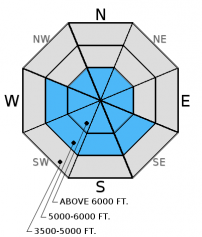
Wind slabs formed on atypical slopes earlier in the week still harbor instabilities. Recent winds have created thin slabs on typical leeward slopes at upper elevations. In some locations these slabs were deposited onto weak snow which adds to their instability. The avalanche danger is MODERATE above 5000 feet where human triggered avalanches are possible. Carefully evaluate wind loaded slopes and keep in mind the potential for a small avalanche to step down in to deeper weak layers.

2. Moderate
?
Above 6500 ft.
2. Moderate
?
5000-6500 ft.
1. Low
?
3500-5000 ft.
- 1. Low
- 2. Moderate
- 3. Considerable
- 4. High
- 5. Extreme
-
Type ?
-
Aspect/Elevation ?

-
Likelihood ?CertainVery LikelyLikelyPossible
 Unlikely
 -
Size ?HistoricVery LargeLargeSmall

Earlier this week, the strong arctic air intrusion was preceded by moderate to strong north-east winds. These winds created slabs on atypical slopes at mid and upper elevations. These slabs have been slow to strengthen due to the recent cold temperatures. Recent winds have deposited snow onto typical leeward aspects forming thin slabs at upper elevations, particularly in the alpine. In the past week we found hard slabs in upper elevations that fractured and propagated with easy force in stability tests (video 1, video 2). Remember, that even a small wind slab release can trigger deeper instabilities and produce a large avalanche. Though the obvious signs of instability like cracking and collapsing may not be present it is still important to carefully evaluate wind loaded terrain before committing to a slope.
-
Type ?
-
Aspect/Elevation ?

-
Likelihood ?CertainVery LikelyLikelyPossible
 Unlikely
 -
Size ?HistoricVery LargeLargeSmall

Weak snow in the lower to mid snow pack exists in most locations across the advisory area. This weeks cold temperatures have further exacerbated this problem. In areas with a shallow snowpack, depth hoar can be found at the ground. In areas where the early December rain crust exists, facets sandwich this crust. The cold period in mid-December left us with a layer of mid pack facets. These layers have been dormant for most of the season mainly due to the lack of a cohesive slab on top of them. In many locations a slab has recently formed on top of these layers and uncertainty remains about the load this weak snow can handle before reaching a tipping point. To address this uncertainty avoid terrain where you are most likely to trigger one of these deeper slides like steep, rocky terrain, and areas with a relatively shallow snowpack. Erich wrote about this in the new Forecaster's Corner.
We are deeply saddened to report that a skier sustained fatal injuries in an avalanche accident on Stanton Mountain in Glacier National Park Thursday, 01/05/2017. We extend our most sincere condolences to the family and friends. FAC staff, along with Glacier National Park Rangers, vistited the site on Friday. We will provide a complete report of their findings within a few days.
Friday: Mark and 2 Glacier National Park Rangers visited Mt. Stanton in GNP. They found a relatively shallow snowpack with weak snow at the ground at mid and upper elevations. Wind slabs formed during the New Year's Day arctic intrusion were also noted. BNSF Avalanche Safety toured in John F. Stevens Canyon and observed a variety of wind slabs at mid and upper elevations. Shooting cracks in the surface slab were noted in isolated locations. Depth hoar was found at the bottom of the pack and had developed into larger grains than what was last viewed in this location 2 weeks ago.
Thursday, Zach was in the Crystal Drainage in the Flathead Range. He found wind affected snow above 6000' that was minimally reactive in stability tests. He also noted facets developing in the upper snowpack at all elevations. He observed wind transporting snow on the surrounding high peaks.
Tuesday: Todd and Seth traveled to Noisy Knob in the Swan Range. Hard wind slabs on all aspects at upper and mid elevations were observed as well as some facets at the ground level in shallow pits. The wind crusts were variable in strength, thickness, and reactivity. On a northwest aspect an Extended Column Test produced a fracture with propagation using easy force (ECTP 4) in a thin (10 inch), hard wind slab.
See below for all observations this season.
Today, will be another cool dry day with strong inversions in place. Currently, mountain temperatures range from 3-17ºF, and winds are out of the southwest at 4-10 mph with gusts from 9-16 mph. Late tonight the first of a series of warm wet air masses will enter our area.
| 0600 temperature: | 3-17 deg. F. |
| Max. temperature in the last 24 hours: | 7-18 deg. F. |
| Average wind direction during the last 24 hours: | SW |
| Average wind speed during the last 24 hours: | 5-10 mph |
| Maximum wind gust in the last 24 hours: | 11-25 mph |
| New snowfall in the last 24 hours: | 0 inches |
| Total snow depth: | 50-66 inches |
This advisory applies only to backcountry areas outside established ski area boundaries. This advisory describes general avalanche conditions and local variations always occur. This advisory expires at midnight on the posted day unless otherwise noted. The information in this advisory is provided by the USDA Forest Service who is solely responsible for its content.


