| Thursday | Thursday Night | Friday | |
|---|---|---|---|
| Cloud Cover: | Mostly clear becoming partly cloudy. | Partly Cloudy and cold. | Partly Cloudy. |
| Temperatures: | 3-13 deg. F. | -11--3 deg. F. | 7-12 deg. F. |
| Wind Direction: | Southwest | Southwest | Southwest |
| Wind Speed: | 5-6 gusts 16 | 5-6 | 5-8 gusts 20 |
| Snowfall: | 0 in. | 0 in. | 0 in. |
| Snow Line: |
Whitefish Range
Swan Range
Flathead Range and Glacier National Park
How to read the forecast
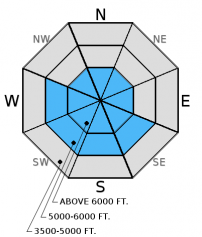
Wind slabs formed early in the week may no longer present obvious signs of instability and may prove stubborn in stability tests. However, it remains possible to trigger an avalanche in these ageing slabs particularly where they formed on weak, faceted snow. The avalanche danger is MODERATE above 5000 feet. Carefully evaluate wind loaded areas before committing to a slope and keep in mind that small wind slab avalanches could step down to deeper weak layers in the snowpack.

2. Moderate
?
Above 6500 ft.
2. Moderate
?
5000-6500 ft.
1. Low
?
3500-5000 ft.
- 1. Low
- 2. Moderate
- 3. Considerable
- 4. High
- 5. Extreme
-
Type ?
-
Aspect/Elevation ?

-
Likelihood ?CertainVery LikelyLikelyPossible
 Unlikely
 -
Size ?HistoricVery LargeLargeSmall

Though the strong winds from early in the week subsided they left slabs on multiple aspects that vary in density, reactivity, and thickness. Over the past week we found hard slabs in upper elevations that fractured and propagated with easy force in stability tests (video 1, video 2). Carefully evaluate any wind loaded terrain that you intend to ski or ride including cross-loaded slopes at mid elevations. Keep in mind that many of these recent slabs were built on weak, faceted snow so a small wind slab avalanche could step down to deeper layers in the snowpack.
Weak snow in the lower to mid snow pack exists in most locations across the advisory area. These layers include weak snow (facets) formed during the cold period in mid-December (image), facets surrounding an early December rain crust, and weak snow near the ground in areas with a shallow snowpack. These layers have been dormant for most of the season mainly due to the lack of a cohesive slab on top of them. Now that we have a slab in the equation in many locations uncertainty remains about the load this weak snow can handle before reaching a tipping point. To address this uncertainty avoid terrain where you are most likely to trigger one of these deeper slides like steep, rocky terrain, and areas with a relatively shallow snowpack. Erich wrote about this in the new Forecaster's Corner.
Tuesday: Todd and Seth traveled to Noisy Knob in the Swan Range. Hard wind slabs on all aspects at upper and mid elevations were observed as well as some facets at the ground level in shallow pits. The wind crusts were variable in strength, thickness, and reactivity. On a northwest an Extended Column Test produced a fracture with propagation using easy force (ECTP 4) in a thin (10 inch), hard wind slab.
Monday: We visited the southern Whitefish Range outside the boundary of Whitefish Mountain Resort. They found hard wind slabs on northeast aspects as well as weaker faceted snow 2.5 feet deeper in the snowpack that fractured and propagated in our stability tests.
See below for all observations this season.
The arctic airmass parked over the region is expected to remain for the next few days. Temperatures struggled to rise out of the single digits yesterday despite the clear/sunny skies. Currently, mountain temperatures have warmed to 0-10º F, and winds are variable from 2-11 mph with gusts to 15 mph. Today, expect cold temperatures to persist with light south/southwest winds.
| 0600 temperature: | 0-5 deg. F. |
| Max. temperature in the last 24 hours: | 5-12 deg. F. |
| Average wind direction during the last 24 hours: | Variable |
| Average wind speed during the last 24 hours: | 5-10 mph |
| Maximum wind gust in the last 24 hours: | 10-15 mph |
| New snowfall in the last 24 hours: | 0 inches |
| Total snow depth: | 52-68 inches |
This advisory applies only to backcountry areas outside established ski area boundaries. This advisory describes general avalanche conditions and local variations always occur. This advisory expires at midnight on the posted day unless otherwise noted. The information in this advisory is provided by the USDA Forest Service who is solely responsible for its content.


