| Wednesday | Wednesday Night | Thursday | |
|---|---|---|---|
| Cloud Cover: | Tapering light snow and light to moderate wind. | Mostly cloudy with light to moderate winds. | Mostly Cloudy with light to moderate winds. |
| Temperatures: | 20 to 29 deg. F. | 10 to 18 deg. F. | 22 to 30 deg. F. |
| Wind Direction: | West | Southwest | South to Southwest |
| Wind Speed: | 12-16 mph with gusts to 29 mph | 10-12 mph with gusts to 25 mph | 7-10 mph with gusts to 29 mph |
| Snowfall: | 0-2 in. | 0-1 in. | 0-2 in. |
| Snow Line: |
Whitefish Range
Swan Range
Flathead Range and Glacier National Park
How to read the forecast
The storm left us with great snow to play in, but also reactive wind and storm slabs. Human triggered avalanches are likely and natural avalanches are possible. The avalanche danger above 5000 feet is CONSIDERABLE. Below 5000 feet, the danger is MODERATE where it is possible to trigger an avalanche.

3. Considerable
?
Above 6500 ft.
3. Considerable
?
5000-6500 ft.
2. Moderate
?
3500-5000 ft.
- 1. Low
- 2. Moderate
- 3. Considerable
- 4. High
- 5. Extreme
-
Type ?
-
Aspect/Elevation ?

-
Likelihood ?CertainVery LikelyLikelyPossible
 Unlikely
 -
Size ?HistoricVery LargeLargeSmall

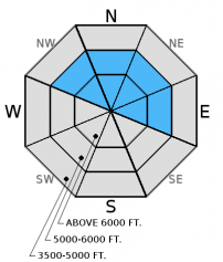
You are likely to trigger a wind slab avalanche at upper and mid-elevations today. The new snow from the last storm combined with strong winds that will only partly be moderating today have and will continue to form sensitive wind slabs at all elevations. At upper elevations, these slabs could be up to 2.5 feet thick. Avoid wind loaded or cross-loaded terrain completely today as you will likely see small avalanches in many areas or large avalanches in exposed, wind loaded terrain.
-
Type ?
-
Aspect/Elevation ?

-
Likelihood ?CertainVery LikelyLikelyPossible
 Unlikely
 -
Size ?HistoricVery LargeLargeSmall

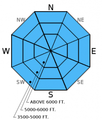
Although the storm has mostly passed us by, new snow through this morning could still be sensitive. The new snow fell on a layer of lower density snow from Monday (12/26), and this layer may have trouble supporting this new snow on steep (>35 degree) slopes. Watch for obvious signs of instability like recent avalanche activity, cracking out from your sled or skis, and whumpfing of the snowpack. Stick to lower angled slopes and avoid runout zones today to avoid this avalanche problem. Loose snow sluffs involving the new storm snow are also possible today in steep terrain.
The storm has mostly passed, but poor visibility and accumulating snow has made it difficult to identify any recent avalanche activity. We expect human triggered avalanches and some natural activity to occur today. We need to allow the snowpack time to adjust to the storm load.
Hard wind slabs formed last week could become a problem with the new storm load. It's important to assess the middle snowpack for potential weak layers like surface hoar and weak, faceted snow that formed during the cold period from 12/13 to 12/19. The hard wind slab overlies these layers and, with the storm load, these layers could become reactive. Look for these weak layers 2-4 feet from the surface. While these layers have not shown obvious signs of instability nor have they been reactive in stability tests, they should not be ignored. In some locations, like John F. Stevens Canyon and areas near the Continental Divide you may find weak (faceted) snow around crusts near the ground (video). The most common places to trigger these deeper slides are in steep, rocky terrain, and areas with a relatively shallow snowpack.
Tuesday: BNSF Avalanche Safety reported avalanche debris at about 4800 feet in John F. Stevens Canyon in southern Glacier Park. Visibility was poor and they could not see the starting zone. Skiers in Pinnacle Creek in the Flathead Range reported poor stability involving the new storm snow in stability tests as well as cracking of this new surface snow. They also reported fracturing and propagation on a layer of weak facets near the bottom of a shallow snowpack.
Todd and Seth traveled from the Canyon Creek TH to Werner Peak in the South Whitefish Range. Visibility was very poor because of snow fall and winds. They observed very small slides on the steep cut banks above the Canyond Creek Road that likely took place at the beginning of the storm cycle. Wind loading was obvious on exposed slopes. They also found weak facets at the ground in a shallow pit on a southwest aspect.
See below for all observations this season.
We are just seeing the end of a potent storm that moved through Tuesday and last night. As of 6:00 a.m., 4 to 16 inches of new snow has accumulated across the advisory area from this storm. Currently, mountain temperatures above 6000 feet range from 13-20º F, and winds are out of the west to southwest at 14-25 mph with gusts from 29-35 mph. Today, temperatures will range from 18-22º F with moderate west winds. Expect 0 to 2 inches of new snow (0 to 0.089 inches of snow water equivalent) by tonight.
| 0600 temperature: | 13 to 19 deg. F. |
| Max. temperature in the last 24 hours: | 17 to 22 deg. F. |
| Average wind direction during the last 24 hours: | Southwest |
| Average wind speed during the last 24 hours: | 5-25 mph |
| Maximum wind gust in the last 24 hours: | 12-46 mph |
| New snowfall in the last 24 hours: | 3-7 inches |
| Total snow depth: | 52-76 inches |
This advisory applies only to backcountry areas outside established ski area boundaries. This advisory describes general avalanche conditions and local variations always occur. This advisory expires at midnight on the posted day unless otherwise noted. The information in this advisory is provided by the USDA Forest Service who is solely responsible for its content.


