| Friday | Friday Night | Saturday | |
|---|---|---|---|
| Cloud Cover: | Increasing clouds with light snow developing. | Light - moderate snow. | Cooler temperatures, increasing winds with light-moderate snow. |
| Temperatures: | 21-29 deg. F. | 10-18 deg. F. | 16-26 deg. F. |
| Wind Direction: | South-Southeast | East-Northeast | Northeast |
| Wind Speed: | 5 | 7-9 gusts 20 | 12-14 gusts 25-29 |
| Snowfall: | 2 in. | 2-4 in. | 2-5 in. |
| Snow Line: |
Whitefish Range
Swan Range
Flathead Range and Glacier National Park
How to read the forecast
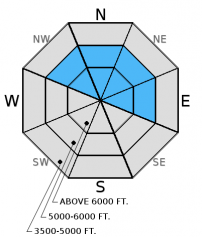
Consistent moderate to strong winds over the past week drifted recent snow and formed slabs on variable surfaces. The avalanche danger is MODERATE above 5000 feet. Human triggered avalanches are possible today, particularly on wind loaded slopes. Carefully evaluate wind loaded terrain and keep in mind that you may encounter a fresh wind slab in areas that you don't expect them.

2. Moderate
?
Above 6500 ft.
2. Moderate
?
5000-6500 ft.
1. Low
?
3500-5000 ft.
- 1. Low
- 2. Moderate
- 3. Considerable
- 4. High
- 5. Extreme
-
Type ?
-
Aspect/Elevation ?

-
Likelihood ?CertainVery LikelyLikelyPossible
 Unlikely
 -
Size ?HistoricVery LargeLargeSmall

Wind slabs formed over the past week vary in thickness, were formed on variable old snow surfaces, and may be encountered in typically sheltered areas. These slabs can take a week to strengthen so continue to treat them with respect as it remains possible for a skier or rider to trigger them. BNSF Avalanche Safety reported an audible collapse (whumph) in a wind slab yesterday which is an obvious sign of instability. In isolated areas you may even encounter a few hard slabs. They will be supportable, feel hollow, and "drummy" and should be avoided. Pay attention to signs of instability like cracking and collapsing in the snowpack.
As the storm snow from early in the week settles into a more cohesive slab it is important to continue to evaluate the recent snow and old snow interface. We have a limited number of observations from the alpine so it is important to assess the upper snowpack for potential weak layers like surface hoar and weak, faceted snow that formed during the dry, cold period last week. Look for this weak interface 1-2 feet from the surface and pay attention to obvious signs of instability. Also, in some locations, like John F. Stevens Canyon and approaching the Divide you may find weak (faceted) snow around crusts 1.5-3.5 feet from the surface (video). The most common places to trigger these deeper slides are in steep, rocky terrain, and areas with a relatively shallow snowpack.
Join us at the Kalispell Brewing Company on Tuesday, December 27th to support a great cause by drinking delicious, locally-made beer. Kalispell Brewing will donate $1.00 per every beer sold to Friends of Flathead Avalanche Center (FOFAC) between 5:00 and 8:00 p.m. See you at the brewery!
BNSF Avalanche Safety was in the John F. Stevens Canyon yesterday and found variable conditions both on the surface and snowpack structure. They noted one audible collapse in the snowpack associated with recent windslab (observation). Whitefish Mountain Resort Ski Patrol reported minimal results using explosives for avalanche control.
Wednesday, we were in Canyon Creek in the southern Whitefish Range. There was wide-spread avalanche activity that occurred on Tuesday. Many of the crowns were difficult to see at first glance because they were mostly filled in by snow and wind blown snow. However, we could see remnants of crowns on Skookoleel Ridge and several on the ridgeline to Ghoulies Point. These avalanches ranged in depth from 12 to 18 inches and failed on the old pre-storm surface. Other skiers were in the same area and noted a more dense layer overlying the lighter old snow.
Over the past 24 hours temperatures climbed to the upper-20s and wind speeds were 10-20 mph with gusts in the 40s out of the west and southwest. Currently, mountain temperatures range from 15-22º F, and winds are out of the southwest at 6-9 mph with gusts from 13-18 mph. Today, temperatures will rise to the mid-20s. Light south and southeast winds should shift and become easterly. Clouds and light snow move in to the area later this morning snow should increase in intensity this afternoon/evening.
| 0600 temperature: | 15-22 deg. F. |
| Max. temperature in the last 24 hours: | 20-29 deg. F. |
| Average wind direction during the last 24 hours: | W/SW |
| Average wind speed during the last 24 hours: | 8-20 mph |
| Maximum wind gust in the last 24 hours: | 27-51 mph |
| New snowfall in the last 24 hours: | 0 inches |
| Total snow depth: | 44-63 inches |
This advisory applies only to backcountry areas outside established ski area boundaries. This advisory describes general avalanche conditions and local variations always occur. This advisory expires at midnight on the posted day unless otherwise noted. The information in this advisory is provided by the USDA Forest Service who is solely responsible for its content.


