| Thursday | Thursday Night | Friday | |
|---|---|---|---|
| Cloud Cover: | Partly cloudy. | Increasing clouds. | Cooler temperatures with light snow. |
| Temperatures: | 22-31 deg. F. | 11-19 deg. F. | 21-30 deg. F. |
| Wind Direction: | Southwest | Southwest | Southeast |
| Wind Speed: | 8-11 gusts 20-24 | 7-10 gusts 20-25 | 5 gusts 17 |
| Snowfall: | 0 in. | 0-2 in. | 1-2 in. |
| Snow Line: |
Whitefish Range
Swan Range
Flathead Range and Glacier National Park
How to read the forecast
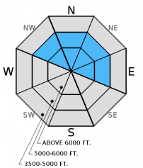
Though natural avalanche activity diminished in the past 24 hours it remains possible for skiers or riders to trigger an avalanche, particularly in recently windloaded terrain. The avalanche danger is MODERATE above 5000 feet. Carefully evaluate recently windloaded areas before you commit to a slope. Keep in mind that winds in the past few days were strong enough to transport snow lower on the slope and into places that may be typically sheltered.

2. Moderate
?
Above 6500 ft.
2. Moderate
?
5000-6500 ft.
1. Low
?
3500-5000 ft.
- 1. Low
- 2. Moderate
- 3. Considerable
- 4. High
- 5. Extreme
-
Type ?
-
Aspect/Elevation ?

-
Likelihood ?CertainVery LikelyLikelyPossible
 Unlikely
 -
Size ?HistoricVery LargeLargeSmall

Snowfall totals from the recent storm range from 12- 20 inches. This snow coupled with strong west and southwest winds formed thick slabs in many locations across the advisory area. Early in the storm we observed small, but sensitive windslabs (video), and yesterday we found multiple crowns from natural wind/storm slab avalanches that occurred on Tuesday. Natural avalanche activity diminished yesterday but human triggered avalanches remain possible. The abnormally strong winds can deposit snow lower on the slope than usual and in areas that are typically sheltered by trees or terrain features. In isolated areas we may even see a few hard slabs. They will feel hollow, and "drummy" and should be avoided. Pay attention to signs of instability like cracking and collapsing in the snowpack.
We have limited observations from the alpine over the past couple of days (which is good given the conditions) so don't rule out slab formation on top of weak snow surfaces from last week's cold snap. Look for layers of weak snow like facets and surface hoar 1-2 feet from the surface and pay attention to obvious signs of instability. Also, in isolated locations, particularly as you approach the divide you may find weak (faceted) snow around crusts 1.5-3.5 feet from the surface (video). The most common places to trigger these deeper slides are in steep, rocky terrain, and areas with a relatively shallow snowpack.
Yesterday, we were in Canyon Creek in the southern Whitefish Range. There was wide-spread avalanche activity that occurred on Tuesday. Many of the crowns were difficult to see at first glance because they were mostly filled in by snow and wind blown snow. However, we could see remnants of crowns on Skookoleel Ridge and several on the ridgeline to Ghoulies Point. These avalanches ranged in depth from 12 to 18 inches and failed on the old pre-storm surface. Other skiers were in the same area and noted a more dense layer overlying the lighter old snow.
Tuesday, BNSF Snow Safety traveled to Shed 7 and reported wind slab development and observed and triggered several small wind slab avalanches. We were in the Red Meadow area and noted strong to extreme winds and lots of new snow and wind loading with surface layers stiffening. Visibility was poor so it was difficult to discover any recent activity. Seth traveled to Noisy Basin and found similar conditions. Monday, Erich traveled in the Marion Lake/Dickey Creek area outside of Essex in the Flathead Range and was able to easily trigger soft wind slabs on leeward aspects (video). Guy was in the backcountry adjacent to Whitefish Mountain Resort (WMR) and observed wind slab development near the ridges in the Canyon Creek area (image).
In the past 24 hours skies cleared and winds slightly moderated though they maintained speeds of 10-25 mph with gusts in 30s. As of 5:00 a.m., mountain temperatures range from 18º-21º F and winds are out of the southwest at 10-20 mph with gusts from 15-38 mph. Today we should see partly cloudy skies with temperatures in the mid-upper 20s, and southwest winds at 5-15 mph with gusts in the 30s. Another system moves into the region late tonight/early tomorrow that should bring another shot of snow to start the weekend.
| 0600 temperature: | 17-21 deg. F. |
| Max. temperature in the last 24 hours: | 18-26 deg. F. |
| Average wind direction during the last 24 hours: | SW |
| Average wind speed during the last 24 hours: | 10-25 mph |
| Maximum wind gust in the last 24 hours: | 16-39 mph |
| New snowfall in the last 24 hours: | 0 inches |
| Total snow depth: | 45-65 inches |
This advisory applies only to backcountry areas outside established ski area boundaries. This advisory describes general avalanche conditions and local variations always occur. This advisory expires at midnight on the posted day unless otherwise noted. The information in this advisory is provided by the USDA Forest Service who is solely responsible for its content.


