| Wednesday | Wednesday Night | Thursday | |
|---|---|---|---|
| Cloud Cover: | Partly to mostly cloudy. | Partly cloudy. | Partly to mostly cloudy. |
| Temperatures: | 24 to 31 deg. F. | 8 to 16 deg. F. | 22 to 28 deg. F. |
| Wind Direction: | Southwest to West | Southwest | Southwest to South |
| Wind Speed: | 10 mph with gusts to 23 mph. | 9-11 with gusts to 24 mph. | 7-11 mph with gusts to 29 mph. |
| Snowfall: | 0 to .02 in. | 0 in. | 0 in. |
| Snow Line: |
Whitefish Range
Swan Range
Flathead Range and Glacier National Park
How to read the forecast
The strong winds and new snow from the recent storm have passed, but dangerous conditions still exist. Natural wind slabs are possible at upper elevations and human-triggered avalanches are likely. Heavier, new snow buried a varitey of surfaces that developed over the last week of colder weather. Careful snowpack evaluation, cautious route finding and conservative decision making are essential. The danger is CONSIDERABLE above 6000 feet and MODERATE below this elevation.

3. Considerable
?
Above 6500 ft.
2. Moderate
?
5000-6500 ft.
2. Moderate
?
3500-5000 ft.
- 1. Low
- 2. Moderate
- 3. Considerable
- 4. High
- 5. Extreme
-
Type ?
-
Aspect/Elevation ?

-
Likelihood ?CertainVery LikelyLikelyPossible
 Unlikely
 -
Size ?HistoricVery LargeLargeSmall

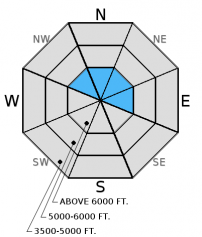
Strong southwest winds combined with over a foot of new snow over the past couple of days, created sensitive wind slabs. These wind slabs were small, but sensitive, Monday (video). We expect both natural and human triggered wind slabs to be larger today. Such strong winds can deposit snow lower in the starting zone than usual. Look for smooth rounded pillows of snow as well as cracking and collapsing in the snowpack. Given the current conditions, approach wind loaded slopes with caution and skepticism today.
-
Type ?
-
Aspect/Elevation ?

-
Likelihood ?CertainVery LikelyLikelyPossible
 Unlikely
 -
Size ?HistoricVery LargeLargeSmall

Lingering storm slabs may still exists. The last storm dropped over a foot of light snow throughout the advisory area. This storm was much warmer than the previous storms over the past week, and the snow is much heavier. This creates an upside-down snowpack. The lighter layer beneath is unable to support the weight of the new snow. Natural storm slab avalanches are possible and human triggered storm slab avalanches are likely on all aspects at mid- to upper elevations. Choose terrain wisely today.
In isolated locations, we continue to find buried weak snow (facets) and weak snow around crusts. The load from the recent storm and a human trigger could awaken these deeper weak layers and cause larger avalanches in these locations. These layers exist 1.5 to 3.5 feet from the snow surface now. Prior to this storm, stability tests indicated the potential for these deeper weak layers to fracture and propagate across the slope, but this was becoming less common. However, it is certainly more common in areas closer to the Continental Divide (like Skyland and John F. Stevens Canyon) where the snowpack is much shallower (video).
Yesterday, BNSF Snow Safety traveled to Shed 7 and reported wind slab development and observed and triggered several small wind slab avalanches. Todd and Erich were in the Red Meadow area and noted strong to extreme winds and lots of new snow and wind loading with surface layers stiffening. Visibility was poor so it was difficult to discover any recent activity. Seth traveled to Noisy Basin and found similar conditions. Monday, Erich traveled in the Marion Lake/Dickey Creek area outside of Essex in the Flathead Range and was able to easily trigger soft wind slabs on leeward aspects (video). Guy was in the backcountry adjacent to Whitefish Mountain Resort (WMR) and observed wind slab development near the ridges in the Canyon Creek area (image).
Over the past 24 hours, 5 to 12 inches of snow has fallen across our advisory area with strong southwest winds at 15-30 mph with gusts to 52 mph. Currently, temperatures above 6000 feet range from 17º to 24º F, and winds are out of the south-southwest at 0 to 10 mph. Today, temperatures will range from 22º to 25º F with southwest winds of 10 to 14 mph and gusts to 30 mph. Snow showers should have tapered off and stopped by this morning.
Storm totals across the advisory area have been between 12 to 20 inches. The heavier snowfall on top of lighter snow has led to a good deal of settling within the snowpack making determining exactly how much snow was received more difficult. SWE amounts have also been impressive from 1.1 to over 2 inches.
| 0600 temperature: | 17-24 deg. F. |
| Max. temperature in the last 24 hours: | 26-33 deg. F. |
| Average wind direction during the last 24 hours: | Southwest |
| Average wind speed during the last 24 hours: | 20 to 30 mph |
| Maximum wind gust in the last 24 hours: | 40 to 52 mph |
| New snowfall in the last 24 hours: | 3-9 inches |
| Total snow depth: | 46-65 inches |
This advisory applies only to backcountry areas outside established ski area boundaries. This advisory describes general avalanche conditions and local variations always occur. This advisory expires at midnight on the posted day unless otherwise noted. The information in this advisory is provided by the USDA Forest Service who is solely responsible for its content.


