| Thursday | Thursday Night | Friday | |
|---|---|---|---|
| Cloud Cover: | Snow showers. | Cold with light snow showers. | Partly cloudy and cold with light snow showers. |
| Temperatures: | 6-14 deg. F. | -12--1 deg. F. | -6-6 deg. F. |
| Wind Direction: | NE | NE | NE |
| Wind Speed: | 11-12 gusts 23-24 | 14-16 gusts 35-37 | 15-16 gusts 35 |
| Snowfall: | 1-3 in. | 0-2 in. | 0-1 in. |
| Snow Line: |
Whitefish Range
Swan Range
Flathead Range and Glacier National Park
How to read the forecast
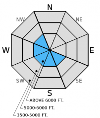
Another shift in wind direction with increased speeds occured overnight. A few days of settlement and drifting will make the snow less likely to move and form slabs, but sustained upper elevation winds in the mid-20s will do the trick. New and reactive wind slabs should be isolated to exposed slopes in the alpine. The avalanche danger is MODERATE above 6000 feet. Pay attention to obvious signs of instability in recently wind loaded terrain like cracking and collapsing.

2. Moderate
?
Above 6500 ft.
1. Low
?
5000-6500 ft.
1. Low
?
3500-5000 ft.
- 1. Low
- 2. Moderate
- 3. Considerable
- 4. High
- 5. Extreme
-
Type ?
-
Aspect/Elevation ?

-
Likelihood ?CertainVery LikelyLikelyPossible
 Unlikely
 -
Size ?HistoricVery LargeLargeSmall

As the snow from the most recent storm settles it becomes less likely to be moved around. However, with wind speeds in the mid-20s I expect to see some new slabs today. This problem should be confined to leeward ridgelines and cross-loaded terrain features at upper-elevations. Look for smooth, rounded features on the snow surface and pay attention to obvious signs of instability like cracking while traveling along rigelines.
In some locations across the advisory area we continue to find buried weak snow/crust combinations. These layers are 1.5-2.5 feet deep. Though recent stability tests indicate minimal reactivity they continue to warrant careful assessment before committing to a slope. Slab formation due to new snow, wind drifted snow, or settlement could awaken these layers and cause them to become more reactive. Areas that are particularly notorious for harboring these layers are shallow, steep, and rocky.
Yesterday we were in Noisy/Jewel Basin in the Swan Range. We dug several snow pits and identified a few layers of weak snow surrounding crusts buried in the snowpack that were not reactive in stability tests. Our primary concern in this area was at the snow surface. We found small grains of weak snow, as well as mature surface hoar (up to 2cm) that could become problematic once buried. A separate party of skiers in Noisy Basin had similar findings. They noted a rain crust about 20 inches deep that was sandwiched by weak snow, but also showed minimal reactivity in stability tests.
Seth toured to Jenny Lake/Blaine Mountain in the Northern Swan Range on Tuesday. Seth and Guy were in Pinnacle Creek in the Flathead Range Monday.Evidence of recent wind transport was prevalent at the ridgelines but the low density new snow led to very little slab development.
Another chilly day yesterday felt a bit more comfortable once the sun burned through the low clouds. Currently temperatures above 6000 feet are between 0-15º F, and winds shifted to the east and northeast blowing at 10-20 mph with gusts from 15-30 mph. Today should bring mostly cloudy skies with light snow showers. Temperatures will rise to the mid-teens and winds will continue out of the east/northeast at 5-15 mph gusting to the low 30s.
| 0600 temperature: | 0-15 deg. F. |
| Max. temperature in the last 24 hours: | 8-15 deg. F. |
| Average wind direction during the last 24 hours: | E/NE |
| Average wind speed during the last 24 hours: | 5-15 mph |
| Maximum wind gust in the last 24 hours: | 11-29 mph |
| New snowfall in the last 24 hours: | 0-1 inches |
| Total snow depth: | 39-61 inches |
This advisory applies only to backcountry areas outside established ski area boundaries. This advisory describes general avalanche conditions and local variations always occur. This advisory expires at midnight on the posted day unless otherwise noted. The information in this advisory is provided by the USDA Forest Service who is solely responsible for its content.


