| Wednesday | Wednesday Night | Thursday | |
|---|---|---|---|
| Cloud Cover: | Cold and dry with decreasing winds. | Cloudy with increasing chance of snow | Cloudy with snow showers |
| Temperatures: | 10-19 deg. F. | 1-12 deg. F. | 9-20 deg. F. |
| Wind Direction: | Southeast to Southwest | East to North | Northeast |
| Wind Speed: | 3-4 | 6-7 | 9-10 |
| Snowfall: | 0 in. | 1-3 in. | 1-3 in. |
| Snow Line: |
Whitefish Range
Swan Range
Flathead Range and Glacier National Park
How to read the forecast
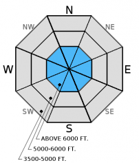
Moderate winds with occasional strong gusts over the last few days from variable directions have caused wind transport of mostly low density snow, but there has been little indication of slab development. Any windslabs formed will be variable in distribution and sensitivity and may be reactive to human triggers. The avalanche danger is MODERATE in windloaded terrain above 5000 feet, and LOW elsewhere. Carefully evaluate potential windloaded areas before committing to a slope.

2. Moderate
?
Above 6500 ft.
2. Moderate
?
5000-6500 ft.
1. Low
?
3500-5000 ft.
- 1. Low
- 2. Moderate
- 3. Considerable
- 4. High
- 5. Extreme
-
Type ?
-
Aspect/Elevation ?

-
Likelihood ?CertainVery LikelyLikelyPossible
 Unlikely
 -
Size ?HistoricVery LargeLargeSmall

Cold temperatures have retained an abundance of low density snow available for wind transport. Winds over the last few days have been moderate with some stronger gusts and variable in direction. Wind slab formation can be expected at upper elevations and possible on any aspects. Where wind slabs do exist, expect they could be reactive to human triggers. Fresh wind slabs can take time to stabilize. Look for smooth, rounded features and areas that appear to have a deeper snowpack along leeward ridgelines and likely cross-loaded terrain. Pay attention to obvious signs of instability like cracking or collapsing.
Continue to pay attention to weak layers buried deeper in the snowpack that continue to show some signs of instability. A freezing rain crust exists in the Whitefish Range and has also been found in the Northern Swan Range. Also a layer of weak snow (facets and/or surface hoar) exists 2+ feet below the surface. In multiple observations last week our stability tests indicated this layer has the ability to fracture, and this fracture can propagate across the slope (video). We have not observed avalanche activity associated with these weak layers in nearly 2 weeks which may be due to lack of overlying slab development. Dig into the snow and look for these potential weak layers. Where present, choose less complex terrain. Avoid areas where the snowpack is relatively shallow and steep, rocky areas.
____________________________________________________________________________________________________________
Join us on Wednesday, December 14 for a free motorized avalanche awareness presentation at Penco Power Products in Kalispell at 6:30.
Seth toured to Jenny Lake/Blaine Mountain in the Northern Swan Range on Tuesday. Seth and Guy were in Pinnacle Creek in the Flathead Range Monday.Evidence of recent wind transport was prevalent at the ridgelines but the low density new snow led to very little slab development.
Sunday, skiers in the backcountry outside of WMR reported wind transport with estimated 20 mph wind speed. Snowpit stability tests resulted in propagation with moderate force on the rain crust layer. Skiers in the Apgar Range in Glacier National Park noted a shallow snowpack with a poor structure and associated signs of instability like collapsing (whumfing).
Saturday, Mark explored the terrain east of WMR and noted 4 small storm slab avalanches that had released on the old snow/new snow interface. One skier triggered small wind slab avalanche was also observed. BNSF Snow Safety also reported 8-10" of low density (5%) snow overnight on the valley floor. They also noted wind loading onto easterly upper elevation aspects and small storm slabs that released on low elevation cutbanks. Skiers in the backcountry outside of WMR found a mostly cohesionless surface except in open/exposed areas where the wind was creating a more cohesive snow surface.
Yesterday saw clearing skies with light to moderate winds. No new snow accumulations in the past 24 hours. Currently, temperatures above 6000 feet range from 8-16º F , and winds out of the west/southwest at 2-7 mph. Today should see mostly clear skies with light south to westerly winds, and cool temperatures only rising to the mid-teens. Clouds move in late afternoon to evening bringing chances of precipitation tonight.
| 0600 temperature: | -7-5 deg. F. |
| Max. temperature in the last 24 hours: | 8-14 deg. F. |
| Average wind direction during the last 24 hours: | W/SW |
| Average wind speed during the last 24 hours: | 1-10 mph |
| Maximum wind gust in the last 24 hours: | 11-22 mph |
| New snowfall in the last 24 hours: | 0 inches |
| Total snow depth: | 41-62 inches |
This advisory applies only to backcountry areas outside established ski area boundaries. This advisory describes general avalanche conditions and local variations always occur. This advisory expires at midnight on the posted day unless otherwise noted. The information in this advisory is provided by the USDA Forest Service who is solely responsible for its content.


