| Sunday | Sunday Night | Monday | |
|---|---|---|---|
| Cloud Cover: | Warming with light to moderate snow showers. | Arctic air returns with light-moderate snow. | Much cooler with snow decreasing. |
| Temperatures: | 17-27 deg. F. | -4 to 12 deg. F. | 8-18 deg. F. |
| Wind Direction: | Southwest | West - Southwest | North - Northwest |
| Wind Speed: | 8-11 mph with gusts to 23 | 14 mph with gusts to 29 | 16 mph with gusts to 31 |
| Snowfall: | 2-8 in. | 4-10 in. | 1-3 in. |
| Snow Line: |
Whitefish Range
Swan Range
Flathead Range and Glacier National Park
How to read the forecast
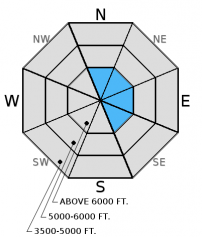
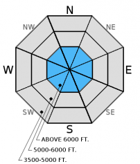
Wind slabs have formed on top of low density snow on upper elevation leeward aspects. Increasing winds today will thicken these slabs. The avalanche danger is CONSIDERABLE above 6000 feet on leeward aspects where human triggered avalanches will be likely. MODERATE danger exists on all other aspects. Today's relatively warm dense snowfall will be deposited onto cold low density snow which may form storm slabs. Evaluate all slopes before recreating on them.

3. Considerable
?
Above 6500 ft.
2. Moderate
?
5000-6500 ft.
1. Low
?
3500-5000 ft.
- 1. Low
- 2. Moderate
- 3. Considerable
- 4. High
- 5. Extreme
-
Type ?
-
Aspect/Elevation ?

-
Likelihood ?CertainVery LikelyLikelyPossible
 Unlikely
 -
Size ?HistoricVery LargeLargeSmall

Although winds were light over the past 24 hours they were sufficiently strong enough to drift the low density surface snow. On our tour yesterday we noticed one small skier triggered wind slab avalanche in a relatively sheltered location. Wind speeds are forecast to increase today and wind slabs will develop as the day progresses. These denser slabs will be deposited onto a weaker layer (the low density surface snow). Continue to look for signs of recent wind-loading such as shooting cracks, whumphing and smooth pillows of snow especially in exposed terrain above 6000 feet.
-
Type ?
-
Aspect/Elevation ?

-
Likelihood ?CertainVery LikelyLikelyPossible
 Unlikely
 -
Size ?HistoricVery LargeLargeSmall

Weak layers buried deeper in the snowpack continue to show some signs of instability. A freezing rain crust exists in the Whitefish Range. Also a layer of weak snow (facets and/or surface hoar) exists 2+ feet below the surface that formed last week. On three field days this week our stability tests indicated this layer has the ability to fracture, and this fracture can propagate across the slope (video). Dig into the snow and look for these potential weak layers. Where present, choose less complex terrain. Avoid areas where the snowpack is relatively shallow and steep, rocky areas.
This early in the season we have relatively limited observations due to difficult access. So there is still some uncertainty in the distribution of these layers and reactivity with the most recent snow load.
-
Type ?
-
Aspect/Elevation ?

-
Likelihood ?CertainVery LikelyLikelyPossible
 Unlikely
 -
Size ?HistoricVery LargeLargeSmall

Small natural storm slab avalanches were observed at both upper and lower elevations yesterday. Another round of relatively warm snowfall is forecast through the day today which will add additional weight to the relatively warm snow that fell over the past 36 hours. This snow is being deposited onto a thick layer of cold low density snow forming a surface "upside down" snow structure. These storm slabs can be identified by cracking and whumphing. Being a surface snow problem this is relatively easy to identify by looking at the near surface snow structure.
Remember, the avalanche advisory is a starting point for decision making. The actual avalanche hazard could be greater or lower where you are traveling, especially due to limited early season observations.
We really appreciate the steady flow of observations. Please continue to help us out by letting us know what you are seeing out there. Remember, that even very simple observations like recent avalanche activity, no avalanche activity, or recent snow depths are a huge help. Thank you!
____________________________________________________________________________________________________________
Join us on Wednesday, December 14 for a free motorized avalanche awareness presentation at Penco Power Products in Kalispell at 6:30.
Saturday, BNSF Snow Safety reported 8-10" of low density (5%) snow overnight on the valley floor. They also noted wind loading onto easterly upper elevation aspects and small storm slabs that released on low elevation cutbanks. Skiers in the backcountry outside of WMR found a mostly cohesionless surface except in open/exposed areas where the wind was creating a more cohesive snow surface. Mark also explored the terrain east of WMR and noted 4 small storm slab avalanches that had released on the old snow/new snow interface. 1 small skier triggered wind slab avalanche was also observed.
Friday, Mark traveled to the Skookoleel area of the southern Whitefish Range. We found a snow surface on all aspects that mostly consisted of cold low density snow. On a southerly aspect we had propagation in our stability tests that mirrored what Erich found Tuesday in Big Slide.
Also on Friday skiers in the Marion Lake area of the Flathead Range found a thick layer of low density unconsolidated snow on a southerly aspect. This layer sat on top of a crust but no results were observed in stability tests.
Wednesday BNSF Avalanche Safety traveled above Sheds 11 and 10.7. Some wind slabs had formed in cross-loaded gullies above 5000 feet but were unreactive. No avalanche activity was observed. Winds were light to calm all day with no active wind-loading.
Skiers in the southern Whitefish range on Wednesday found a freezing rain crust in their snowpit on a southerly aspect at about 6600 feet. This layer fractured and propagated across the column in a stability test. Skiers in the Middle Fork toured up Snowshed Mountain above Essex. They noted light to moderate winds that were forming thin wind slabs on easterly aspects.
On Tuesday Erich traveled in the southern Whitefish Range. We found weak layers (facets and a freezing rain crust) about 2 feet below the surface and on some aspects these layers fractured and this fracture propagated across the column - a sign of instability (video). Whitefish Mountain Resort Ski Patrol also found wind slabs to fail on the freezing rain crust in isolated locations during their avalanche mitigation work over the past two days.
Yesterday, we enjoyed seasonal temperatures with snow tapering off in the morning and partly cloudy skies during the remainder of the day. As of 6:00 am temperatures above 6000 feet range from 12 - 20° F, and winds are 3-10 mph with gusts to 15 mph out of the south-southwest. For today expect cloudy conditions with light to moderate snow showers and windy conditions developing.
| 0600 temperature: | 13 - 21 deg. F. |
| Max. temperature in the last 24 hours: | 12 - 20 deg. F. |
| Average wind direction during the last 24 hours: | Southwest |
| Average wind speed during the last 24 hours: | 5-10 mph |
| Maximum wind gust in the last 24 hours: | 15-30 mph |
| New snowfall in the last 24 hours: | 1-4 inches |
| Total snow depth: | 40-59 inches |
This advisory applies only to backcountry areas outside established ski area boundaries. This advisory describes general avalanche conditions and local variations always occur. This advisory expires at midnight on the posted day unless otherwise noted. The information in this advisory is provided by the USDA Forest Service who is solely responsible for its content.


