| Wednesday | Wednesday Night | Thursday | |
|---|---|---|---|
| Cloud Cover: | Partly cloudy and cold. | Cold. | Cold and incoming storm in the evening. |
| Temperatures: | 0 to 7 deg. F. | -23 to -16 deg. F. | 1 to 8 deg. F. |
| Wind Direction: | East-Northeast | East-Northeast | East-Northeast |
| Wind Speed: | 5-10 mph | 5-10 mph | 5-15 mph |
| Snowfall: | 0 in. | 0 in. | 0 in. |
| Snow Line: |
Whitefish Range
Swan Range
Flathead Range and Glacier National Park
How to read the forecast
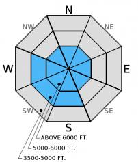
The avalanche danger is MODERATE above 5000 feet. Heightened avalanche conditions exist and human triggered avalanches are possible due to freshly formed wind slabs and weak layers buried deeper in the snowpack. Carefully evaluate wind loaded areas, especially at upper elevations, before committing to any slope. Dig into the snow to assess deeper weak layers, and choose conservative terrain where these weak layers exist.

2. Moderate
?
Above 6500 ft.
2. Moderate
?
5000-6500 ft.
1. Low
?
3500-5000 ft.
- 1. Low
- 2. Moderate
- 3. Considerable
- 4. High
- 5. Extreme
-
Type ?
-
Aspect/Elevation ?

-
Likelihood ?CertainVery LikelyLikelyPossible
 Unlikely
 -
Size ?HistoricVery LargeLargeSmall

Moderate easterly and northerly winds loaded atypical slopes over the past 48 hours. You are most likely to trigger a wind slab in upper elevation, exposed locations (like high ridge lines and alpine terrain) today. This includes the lee sides of ridges, cross-loaded gullies, and other terrain features. These slabs could be more sensitive than yesterday due to an increase in wind speed overnight. It's important to assess any slope for wind slabs due to these atypical wind loading patterns. The skier triggered avalanche reported in the Skook Chutes of the Whitefish Range on Sunday appears to have been a wind slab created by cross loading.
Wind slabs can take as long as week to gain strength so continue to assess all aspects for wind slabs today. Pay attention to obvious signs of instability like cracking, whumphing, and hollow sounds.
-
Type ?
-
Aspect/Elevation ?

-
Likelihood ?CertainVery LikelyLikelyPossible
 Unlikely
 -
Size ?HistoricVery LargeLargeSmall

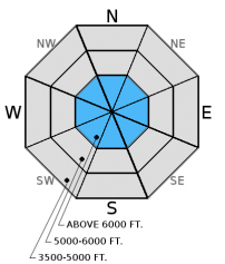
Weak layers exist deeper in the snowpack. While we haven't had reports of avalanches on these weak layers, we can't really call them a problem.....yet. However, due to variabilty in the early season snowpack, I'm listing persistent slab here more as a heads up.
Currently, a layer of weak snow (facets and/or surface hoar) exists about 1.5 to 2 feet below the surface that formed last week. Recent stability tests indicate this layer has the ability to fracture, and this fracture can propagate across the slope (video). A freezing rain crust also exists in the Whitefish Range (but maybe elsewhere, too). This layer also fractures and that fracture propagates in stability tests. The bottom line is a weak layer exists, and it's important to take the time to carefully assess each slope before you ride or ski it. If you are uncertain, then choose conservative terrain. You are more likely to trigger a persistent slab avalanche on slopes with a shallow snowpack and in steep, rocky areas.
We have relatively limited observations due to difficult access so there is still some uncertainty in the distribution of these layers and reactivity with the most recent snow load.
Loose, dry avalanches (sluffs) are also possible with the recent, unconsolidated snow. Sluffs can be dangerous in steep terrain and around terrain traps. The effects of even a small loose, dry avalanche can be amplified by traveling in or near a terrain trap like cliffs, tree islands, or narrow gullies.
Remember, the avalanche advisory is a starting point for decision making. The actual avalanche hazard could be greater or lower where you are traveling, especially due to limited early season observations.
We really appreciate the steady flow of observations. Please continue to help us out by letting us know what you are seeing out there. Remember, that even very simple observations like recent avalanche activity, no avalanche activity, or recent snow depths are a huge help. Thank you!
____________________________________________________________________________________________________________
Thursday December 8, join us at the Sportsman and Ski Haus in Whitefish at 6:30 for a free 1 hour general avalanche awareness presentation.
On Wednesday December 14 join us for a free motorized avalanche awareness presentation at Penco Power Products in Kalispell at 6:30.
Yesterday, my partner and I traveled in the southern Whitefish Range. We found weak layers (facets and a freezing rain crust) about 2 feet below the surface and on some aspects these layers fractured and this fracture propagated across the column - a sign of instability (video). Whitefish Mountain Resort Ski Patrol also found wind slabs to fail on the freezing rain crust in isolated locations during their avalanche mitigation work over the past two days.
On Monday, Todd rode into the Lost Johnny drainage in the Swan Range. He found nearly 2 feet of recent, unconsolidated snow. Wind speeds had moderated, but he were still able to see plumes of drifting snow on distant peaks. Steep slopes produced loose, dry avalanches (sluffs) early, but became a bit more stubborn as the day progressed. Skeirs in the southern Whitefish Range also found sluffing on steep slopes, and no other obvious signs of instabiltiy.
On Sunday a skier triggered a soft slab avalanche in the Skook Chutes of the southern Whitefish Range. The avalanche occurred on a cross loaded slope with the bed surface being the thin crust formed during the snow event of Friday evening. The crown was 8-12" in depth, 50' wide and ran 700'. The skier was able to safely ski out of the slide. Also on Sunday riders in the Red Meadow Pass area of the Whitefish Range noted natural avalanche activity on upper elevation wind loaded northeast aspects.
Overnight, upper elevation temperatures plummeted across the advisory area to as low as -14 degrees F (as of 5:00 a.m.). Winds increased to 17-25 mph out of the east and northeast last night, but have since tapered to 5-10 mph this morning. Today, expect partly cloudy skies with temperatures 0-10 degree F. East-Northeast winds at 5-10 mph will continue through tonight. The next major storm appears to arrive late Thursday into Friday. Also, isolated snow showers may occur near the south of Flathead Lake and could affect portions of the Swan Range today.
Note: SNOTEL sites are not reporting this morning.
| 0600 temperature: | -14 to -4 deg. F. |
| Max. temperature in the last 24 hours: | -4 to 5 deg. F. |
| Average wind direction during the last 24 hours: | North through East |
| Average wind speed during the last 24 hours: | 2 to 17 mph |
| Maximum wind gust in the last 24 hours: | 2 to 25 mph |
| New snowfall in the last 24 hours: | 0 inches |
| Total snow depth: | 33 to 59 inches |
This advisory applies only to backcountry areas outside established ski area boundaries. This advisory describes general avalanche conditions and local variations always occur. This advisory expires at midnight on the posted day unless otherwise noted. The information in this advisory is provided by the USDA Forest Service who is solely responsible for its content.


