| Monday | Monday Night | Tuesday | |
|---|---|---|---|
| Cloud Cover: | Light snowfall with variable winds. | Clearing with cold temperatures. | Arctic air becoming entrenched with dangerous wind chills. |
| Temperatures: | 13-21 deg. F. | -11 to 2 deg. F. | 0-10 deg. F. |
| Wind Direction: | Variable | Northeast | Northeast |
| Wind Speed: | 6 mph with gusts to 16 mph. | 6 mph with gusts to 21 mph. | 9-11 mph with gusts to 28 mph. |
| Snowfall: | 1 in. | 0-1 in. | 0 in. |
| Snow Line: |
Whitefish Range
Swan Range
Flathead Range and Glacier National Park
How to read the forecast
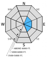
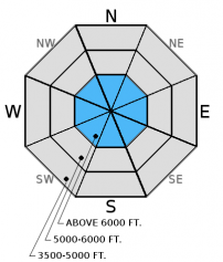
Natural and human triggered avalanches have occurred over the past 24 hours. Windy conditions have loaded upper elevation leeward terrain while recent snow has fallen on a variety of surfaces including sun crusts, surface hoar, and facets. The danger today is CONSIDERABLE above 6000'. Cautious route finding and conservative decision making is essential. As the day progresses northerly winds will load atypical terrain features. Carefully evaluate any slope you plan to recreate on.

3. Considerable
?
Above 6500 ft.
2. Moderate
?
5000-6500 ft.
No Rating
?
3500-5000 ft.
- 1. Low
- 2. Moderate
- 3. Considerable
- 4. High
- 5. Extreme
-
Type ?
-
Aspect/Elevation ?

-
Likelihood ?CertainVery LikelyLikelyPossible
 Unlikely
 -
Size ?HistoricVery LargeLargeSmall

Winds speeds throughout the week have been sufficient to load leeward terrain at both mid and upper elevations. The skier triggered avalanche in the Skook Chutes of the Whitefish Range on Sunday appears to have been a wind slab created by cross loading. The intentionally triggered wind slab avalanche in John F. Stevens Canyon was on a mid elevation cross loaded slope. The natural avalanche activity noted in the northern Whitefish Range was on a upper elevation leeward aspect. Wind slabs can take up to a week to stabilize so give them a wide berth today. As we noticed in John F. Stevens Canyon on Friday, even areas of very thin snow pack can have thick pockets of wind drifted snow. Evaluate all wind loaded terrain today before committing to a slope. Look for smooth rounded pillows on leeward sides of ridges and cross loaded terrain features. Obvious signs of instability will be cracking, whumphing and hollow sounds. As the day progresses be alert for atypical wind deposition due to forecasted northeasterly winds.
-
Type ?
-
Aspect/Elevation ?

-
Likelihood ?CertainVery LikelyLikelyPossible
 Unlikely
 -
Size ?HistoricVery LargeLargeSmall

Snowfall over the past week was deposited on a variety of surfaces including surface hoar, facets, sun crusts and melt freeze crusts. Due to the lack of observations, and difficult access, we do not yet know how widespread of a problem we have with these layers.Natural and human triggered avalanches have occurred on these layers in multiple locations this week. The persistent slab problem is currently located near the snow surface and therefore relatively easy to detect. Spend a few moments poking around the top of the pack to see how this surface slab is adhering to the layers directly below.
24 hour new snow totals as of 0600 range from 3-12 inches across our area with some locations seeing around 1" of water from this storm. In areas favored by this storm dry loose avalanches will be possible especially on sunny aspects.
Due to the lack of observations, and difficult access, we do not yet know how widespread of a problem we have in our snowpack. Please help us by sending in observations on what you are seeing out there. Thanks!
Remember, avalanches can happen any time of the year. The effect of small avalanches can be amplified by thin snow cover, exposed hazards, and narrow gullies. If there is enough snow to ski or ride, it's deep enough to slide.
____________________________________________________________________________________________________________
Thursday December 8, join us at the Sportsman and Ski Haus in Whitefish at 6:30 for a free 1 hour general avalanche awareness presentation.
On Wednesday December 14 join us for a free motorized avalanche awareness presentation at Penco Power Products in Kalispell at 6:30.
On Sunday a skier triggered a soft slab avalanche in the Skook Chutes of the southern Whitefish Range. The avalanche occurred on a cross loaded slope with the bed surface being the thin crust formed during the snow event of Friday evening. The crown was 8-12" in depth, 50' wide and ran 700'. The skier was able to safely ski out of the slide.
Also on Sunday riders in the Red Meadow Pass area of the Whitefish Range noted natural avalanche activity on upper elevation wind loaded northeast aspects.
Saturday, skiers in the Marion Lake area of the Flathead Range reported moderate to strong winds along with snowfall rates of 1/2" per hour on their tour. No signs of instability were noted but they did find a buried surface hoar/facet layer 6-10" below the surface.
Also on Saturday, skiers in both the southern and northern Whitefish Range reported a thin crust 2-3" below the snow surface on all aspects above 6000'. This crust was not supportive and would break on each turn. This likely formed Friday evening as air temperatures warmed for a short duration during the storm. No other signs of instability were observed.
On Friday Mark accompanied BNSF Avalanche Safety in John F. Stevens Canyon in southern Glacier Park. They were able to intentionally trigger 2 small soft slab avalanches on a mid-elevation wind loaded southeast aspect. Moderate winds were noted at mid and upper elevations throughout their tour. Upper elevation cornice formation was impressively large for this early in the season.
Thursday, skiers in the Jewel Basin in the Swan Range reported about 10-14 inches of new snow that was poorly bonded to the old snow surface. They observed and intentionally triggered a few small avalanches on wind drifted aspects up to 12-16 inches deep, and also noticed cracking of the snowpack. On non-wind loaded terrain, they experienced dry sluffing of the new snow.
On Wednesday skiers on Mt. Aeneas in the Swan Range reported moderate winds that were forming 5-10" thick wind slabs on ridgelines. Just below the ridgelines cracking was observed but the slabs were less cohesive. On Tuesday one of these skiers noted a thin layer of facets just above a ice mass 20 cm from the ground. Partial propagation occurred in his ECT on this weak layer.
The main energy of the storm that affected us over the past 24 hours has moved out of our area this morning. Lingering snow showers remain in its wake with much cooler temperatures and lighter winds. As of 6:00 a.m. temperatures at upper elevation weather stations range from the single digits to mid teens with light winds that have shifted to a more northeasterly component. Upper elevation temperatures should top out in the low teens today. Very cold arctic air will move into our area tonight and become fully entrenched by tomorrow morning.
| 0600 temperature: | 7-13 deg. F. |
| Max. temperature in the last 24 hours: | 22-29 deg. F. |
| Average wind direction during the last 24 hours: | SSW |
| Average wind speed during the last 24 hours: | 5-15 mph |
| Maximum wind gust in the last 24 hours: | 18-38 mph |
| New snowfall in the last 24 hours: | 3-12 inches |
| Total snow depth: | 36-60 inches |
This advisory applies only to backcountry areas outside established ski area boundaries. This advisory describes general avalanche conditions and local variations always occur. This advisory expires at midnight on the posted day unless otherwise noted. The information in this advisory is provided by the USDA Forest Service who is solely responsible for its content.


