| Wednesday | Wednesday Night | Thursday | |
|---|---|---|---|
| Cloud Cover: | Dry conditions with warming temps | Snow showers developing | Snow showers ending with slightly cooler temperatures |
| Temperatures: | 41-54 deg. F. | 25-32 deg. F. | 40-52 deg. F. |
| Wind Direction: | N | N | N |
| Wind Speed: | 6 gusts 16 | 12-14 gusts 29 | 12 gusts 23-25 |
| Snowfall: | 0 in. | 0 in. | 0 in. |
| Snow Line: |
Whitefish Range
Swan Range
Flathead Range and Glacier National Park
How to read the forecast
Recent atypical winds have formed wind slabs on a sun crust or onto low density snow atop a sun crust. Previous wind slab development occurred on typical leeward aspects where lingering instabilities remain. Warming temperatures today will weaken surface snow and create wet loose slides. The avalanche danger is MODERATE. Carefully assess terrain for recently formed windslabs along ridgelines and cross-loaded features before committing to a slope. Pay attention to snow surface warming and adjust your travel accordingly.

2. Moderate
?
Above 6500 ft.
2. Moderate
?
5000-6500 ft.
1. Low
?
3500-5000 ft.
- 1. Low
- 2. Moderate
- 3. Considerable
- 4. High
- 5. Extreme
-
Type ?
-
Aspect/Elevation ?
-
Likelihood ?CertainVery LikelyLikelyPossible
 Unlikely
 -
Size ?HistoricVery LargeLargeSmall

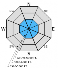
Over the past 36 hours winds have been atypical and blown from north through east. Yesterday, we observed large plumes of snow blowing off the highest peaks by obviously strong winds. These winds have drifted recent low density snow onto normally scoured sunny aspects. In many areas these fresh wind slabs will be depostited onto a sun crust or onto a thin layer of low density snow which is sitting atop this crust. Monday and Tuesday we noticed that the new snow capping the sun crust was not bonding well to that crust. This crust will make for a slippery bed surface and a great sliding layer for these slabs to slide on.
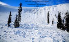
Prior to Monday night, winds moving out of the southwest formed wind slabs on northwest through southeast aspects. We observed natural wind slab avalanches that likely occurred on Monday (observation). Both soft and hard wind slabs exist on all aspects. Pay attention to obvious signs of instability like recent avalanches and cracks shooting out from your skis or machine.
-
Type ?
-
Aspect/Elevation ?
-
Likelihood ?CertainVery LikelyLikelyPossible
 Unlikely
 -
Size ?HistoricVery LargeLargeSmall

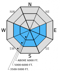
The strength of the spring sun and above freezing temperatures can have dramatic effects on the snowpack, and conditions can change rapidly. The first signs of wet snow instability are rollerballs/pinwheels developing on a slope. This means it is time to move to a more shaded aspect. These slides can entrain a fair amount of snow and knock you off your feet or machine and ruin your day. Wet loose slides have the potential to trigger wind slabs or even deeper layers in the snowpack as well.
-
Type ?
-
Aspect/Elevation ?
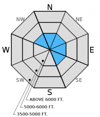
-
Likelihood ?CertainVery LikelyLikelyPossible
 Unlikely
 -
Size ?HistoricVery LargeLargeSmall

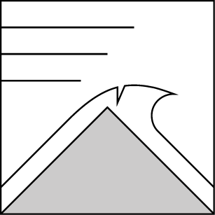
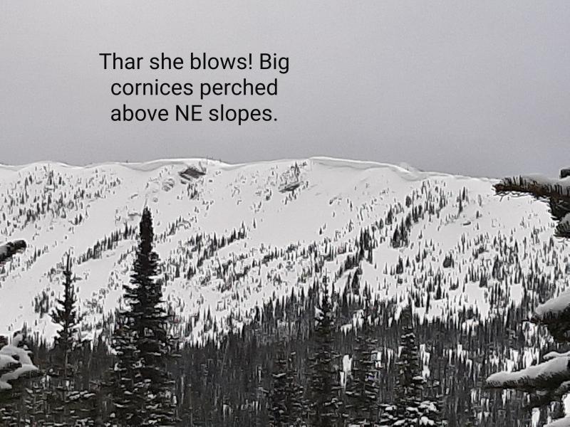
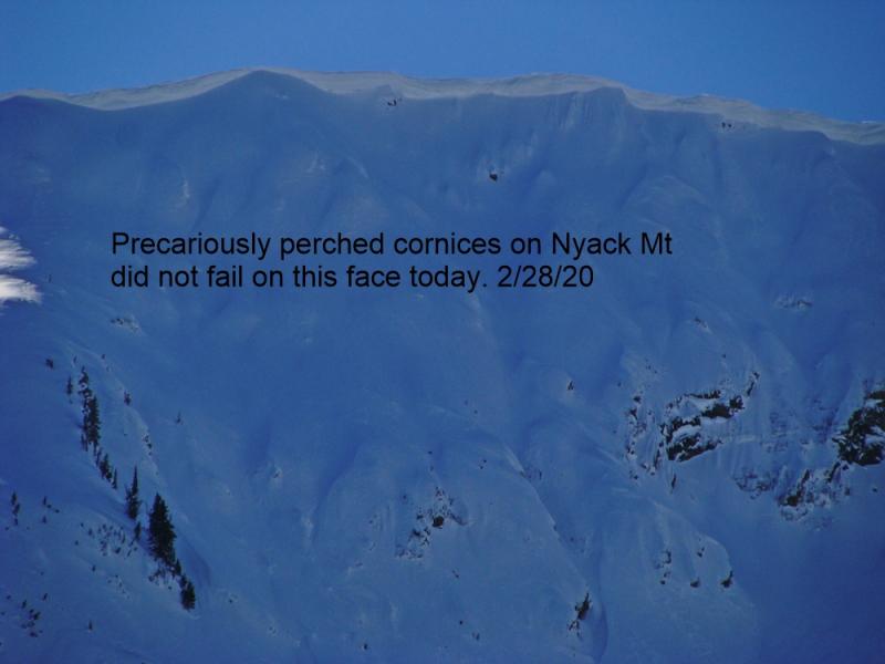
Large cornices exist throughout the advisory area, and spring is the time when these behemoths tend to fail. We observed or received reports of cornice failure every week over the past 2-3 weeks. Warming temperatures today through the weekend will weaken cornices. Stay well back from the edge while traveling along ridges and absolutely minimize your time moving below them. Cornice fall can trigger wind slab avalanches and even awaken deeper instabilities in the snowpack such as the weak snow around the February or March crusts.
Additional concern: We have observed glide cracks starting to open in many locations and several have even failed (image). Given the unpredictable nature of glide avalanches it is best to avoid slopes where they are present.
You may find weak snow surrounding a series of crusts from late February and through March 1. located 1.5 to 3 feet from the surface. These layers have not produced recent avalanches. However, digging into the snow and performing stability tests is the only way to determine if deeper weak layers exist.
Tuesday: We found 8-10 inches of snow above the melt-freeze crust from 3/25 in the Skyland area in the Flathead Range. We observed substantial wind loading from north-northeast winds along the ridges of the highest peaks. We also observed two recent natural avalanches on a northeast aspect of Nyack Mountain that likely occurred Monday 3/28 (observation). Skiers in the Wahoo/Rescue Creek area of the Flathead Range noted recent small wind slab avalanches (same ones we observed, perhaps) on north aspects along with point release activity from the previous few days (observation).
Monday: In the Skookoleel/Canyon Creek area in the southern Whitefish Range Mark found 4 inches of low density snow atop a melt-freeze crust in most locations(observation).
Sunday: Skiers in the Skiumah/Great Bear Drainages in the Flathead Range noted increasing winds as the cold front moved into the area yesterday that was actively drifting the recent snow. They triggered a small pocket of windslab from the ridge, and wisely altered their plan due to new wind slab formation (observation).
Visit our Observations page and our You Tube channel for more observations from the entire season.
Thanks to everyone for submitting observations. They are extremely useful and could help save lives.
HOW TO SUBMIT OBSERVATIONS:
Email: [email protected]
Call and leave a message: 406.387.3821
You can also submit quick observations via text: 406.241.4571 (FAC mobile)
OR
Submit Snowpack Observations: http://www.flatheadavalanche.org/node/add/snowobs
Submit Avalanche Observations: http://www.flatheadavalanche.org/node/add/avyobs
Yesterday was a rather benign weather day with partly sunny skies and seasonal temperatures. The one exception was winds that blew from the north though east. Mountain weather stations recoreded light to moderate wind speeds but at higher elevations it was obvious, from the large plumes of snow moving off the highest peaks, that wind speeds were strong. Today we should enjoy dry conditions with temperatures warming into the upper 30s to mid 40s F and light winds continuing out of the north. Currently, temperatures above 6000 feet range from 25º-32º F, and winds are out of the north-northeast at 3-8 mph with gusts from 8-13 mph. A weak system will enter our area tonight with limited moisture.
| 0600 temperature: | 23-31 deg. F. |
| Max. temperature in the last 24 hours: | 29-38 deg. F. |
| Average wind direction during the last 24 hours: | N-NE |
| Average wind speed during the last 24 hours: | 5-15 mph |
| Maximum wind gust in the last 24 hours: | 13-25 mph |
| New snowfall in the last 24 hours: | 0 inches |
| Total snow depth: | 86-115 inches |
This advisory applies only to backcountry areas outside established ski area boundaries. This advisory describes general avalanche conditions and local variations always occur. This advisory expires at midnight on the posted day unless otherwise noted. The information in this advisory is provided by the USDA Forest Service who is solely responsible for its content.


