| Friday | Friday Night | Saturday | |
|---|---|---|---|
| Cloud Cover: | Warming and sunny. | Clear. | Sunny and Warm. |
| Temperatures: | 28 to 40 deg. F. | 9 to 19 deg. F. | 36 to 48 deg. F. |
| Wind Direction: | East-Northeast | Southeast | Southwest |
| Wind Speed: | 1-5 mph. | 1-5 mph. | 1-5 mph. |
| Snowfall: | 0 in. | 0 in. | 0 in. |
| Snow Line: |
Whitefish Range
Swan Range
Flathead Range and Glacier National Park
How to read the forecast
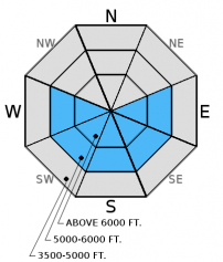
Sunny, warm spring days bring a mix of avalanche problems. Pay attention to how quickly warming affects the new snow from the past week. Both human triggered and natural wet, loose avalanches are possible. Large cornices could also weaken and fail. Lingering wind slabs in the alpine and weak snow above a crust 2-3 feet from from the surface still exist. The danger is MODERATE, but will rise on sunny slopes as the day progresses.

2. Moderate
?
Above 6500 ft.
2. Moderate
?
5000-6500 ft.
1. Low
?
3500-5000 ft.
- 1. Low
- 2. Moderate
- 3. Considerable
- 4. High
- 5. Extreme
-
Type ?
-
Aspect/Elevation ?

-
Likelihood ?CertainVery LikelyLikelyPossible
 Unlikely
 -
Size ?HistoricVery LargeLargeSmall

The nearly 20 inches of new snow we received over the past few days accumulated on top of a rain crust in many locations. With the trigger of intense spring sunshine and rising temperatures, both human triggered and natural wet loose avalanches will become a problem as the day progresses. The past few days we noticed that it only took a few minutes of sunshine and warming to initiate rollerball/pinwheel activity on steep, sunny aspects. These are signs the surface snow is becoming unstable. This is an easy problem to manage. Simply move to a more shaded aspect and avoid being under steep slopes in the sun. With warming and instense sunshine today creating more cohesive slabs, it is not out of the question that you could also trigger a lingering wind or storm slab.
-
Type ?
-
Aspect/Elevation ?

-
Likelihood ?CertainVery LikelyLikelyPossible
 Unlikely
 -
Size ?HistoricVery LargeLargeSmall

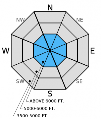
Weak, sugary snow and buried surface hoar atop a crust from late February located 1.5 to 2 feet from the surface are still on our radars. While we have not had recent reports of avalanches releasing on these weak layers, stability tests in most locations show these weak layers still have the potential to break across a slope (video1, video2). These are the types of layers I just don't trust; the kind that will bite you when you are least expecting it. These layers aren't providing obvious signs of instability like cracking or collapsing which makes digging into the snow and doing stability tests important. Though it requires hard force, it shows that a large load (like a cornice fall, perhaps) could trigger these deeper layers especially as temperatures rise above freezing over the next 2 days. A trigger like a skier or a snowmobiler in a more shallow spot could also awaken this deeper layer.
-
Type ?
-
Aspect/Elevation ?

-
Likelihood ?CertainVery LikelyLikelyPossible
 Unlikely
 -
Size ?HistoricVery LargeLargeSmall

The new snow appears to be bonding fairly well to the old snow surface from last Sunday, but lingering wind slabs at upper elevations still exist. We found wind slabs along the Swan Range crest yesterday that cracked on small test slopes. Also, with a switch in wind direction yesterday, wind slabs could be evident on all upper elevation aspects. Given the amount of new snow this week, allow the snowpack time to adjust to the new load especially at upper elevations. Warming and abundant sunshine today could create more cohesive slabs and make them more sensitive to human triggering.
Additional Concerns: As we approach spring and daily maximum temperatures rise above freezing on a more regular basis, cornices (image) will likely become more sensitive and glide cracks could begin to fail (image). Cornices can fail well back from their edges and potentially trigger avalanches that release on deeper weak layers on the slopes below making the consequences more severe. Give cornices a wide berth while traveling along ridges and limit your exposure time when traveling below them. Simply avoid slopes with glide cracks on them.
Thursday: Todd and I rode around the Doris Creek/Blaine Mountain area in the Swan Range yesterday. We found excellent riding with 16-20 inches of snow above the rain crust from last weekend. Wind slabs near the ridges produced isolated cracking, but we avoided steep wind loaded terrain. We also found weak snow above two crusts about 2 -3 feet from the surface that fractured and propagated in our stability tests (observation and video).
Wednesday: In the Skyland area of the Flathead Range, my partner and I found 16 inches of new snow sitting atop the rain crust from last Sunday. We also found weak, sugary snow atop the crust from late February that fractured and propagated in every stability test we conducted yesterday (video and observation). With good visbility we observed no new natural avalanche activity. Skiers in Rescue Creek yesterday found the new snow to be bonding well to the old snow and noted facets surrounding a crust in the upper snowpack (observation).
Tuesday: Mark toured east of the Whitefish Mountain Resort ski area boundary in the southern Whitefish Range where he found 16 inches of new snow since Sunday and evidence of recent wind transport (observation). I was just west of the ski area and found large grain surface hoar 3 feet below the surface that propagated in his ECT tests with hard force. We both found an impressive layer of graupel that was 8 inches below the surface which was adding to the new snow instability.
Monday: Mark traveled to the Marion Lake area of the Flathead Range. Above 6200 feet I found 4-6 inches of new snow sitting atop a rain crust. He were unable to locate buried surface hoar but we did find evidence of recent and current wind loading (observation). Skiers in the southern Whitefish Range had propagation in their stability tests on a layer of facets atop a melt freeze crust 90 cm from the surface (observation)
Sunday: Skiers in the Tranquil Basin/Mt. Furlong area in the Flathead Range found a breakable crust below 5500 feet. At upper elevations they noted multiple crusts within the top 16 inches of the snowpack with weak, facets between them. Their stability tests produced fractures with propagation in this weak snow using hard force (observation).
Visit our Observations page and our You Tube channel for more observations from the entire season.
Thanks to everyone for submitting observations. They are extremely useful and could help save lives.
HOW TO SUBMIT OBSERVATIONS:
Email: [email protected]
Call and leave a message: 406.387.3821
You can also submit quick observations via text: 406.241.4571 (FAC mobile)
OR
Submit Snowpack Observations: http://www.flatheadavalanche.org/node/add/snowobs
Submit Avalanche Observations: http://www.flatheadavalanche.org/node/add/avyobs
A quick pulse of snow slammed the Swan Range with 7 inches of snow in 3 hours yesterday morning for a previous 24 hour total of 12 inches. The rest of the advisory area picked up 1 inch in the past 24 hours. This past week was a nice return of winter. Here are settled storm totals since Sunday night from a few stations in the advisory area:
Big Mountain Summit: 17 inches (1.55 inches of SWE)
Stahl Peak SNOTEL: 5 inches (0.8 inches of SWE)
Noisy Basin SNOTEL: 19 inches (1.9 inches of SWE)
Flattop Mountain SNOTEL: 10 inches (1.5 inches of SWE)
Currently, temperatures above 6000 feet range from 7º-16º F, and winds are out of the northeast at 1-7 mph. Today, expect warming temperatures to the low to mid-30s F, clear skies, and winds moving from the east-northeast at 1-10 mph. Tomorrow, sunny skies and warming temperatures are on the docket.
| 0600 temperature: | 7 to 16 deg. F. |
| Max. temperature in the last 24 hours: | 20 to 33 deg. F. |
| Average wind direction during the last 24 hours: | Northeast |
| Average wind speed during the last 24 hours: | 2-12 mph mph |
| Maximum wind gust in the last 24 hours: | 13-28 mph |
| New snowfall in the last 24 hours: | 1-7 inches |
| Total snow depth: | 83-111 inches |
This advisory applies only to backcountry areas outside established ski area boundaries. This advisory describes general avalanche conditions and local variations always occur. This advisory expires at midnight on the posted day unless otherwise noted. The information in this advisory is provided by the USDA Forest Service who is solely responsible for its content.


