| Tuesday | Tuesday Night | Wednesday | |
|---|---|---|---|
| Cloud Cover: | Light snow showers tapering off this afternoon. | Partial clearing. | Light snow showers. |
| Temperatures: | 32-44 deg. F. | 19-26 deg. F. | 33-44 deg. F. |
| Wind Direction: | SW | SW | SW |
| Wind Speed: | 10-12 | 7-8 gusts 20 in the Flathead Range | 8-10 |
| Snowfall: | 0-1 in. | 0 in. | 0 in. |
| Snow Line: |
Whitefish Range
Swan Range
Flathead Range and Glacier National Park
How to read the forecast
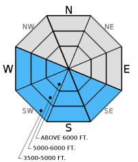
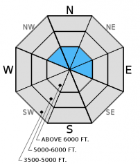
The avalanche danger above 6000 feet is MODERATE. Our snow surface is saturated from rain and sunshine and it will be possible to trigger a wet snow avalanche on steep terrain. At the highest elevations of our area lingering wind slab instabilities still exist on steep windloaded slopes. Evaluate snow and terrain carefully before comitting to a slope. Below 6000 feet the avalanche danger is LOW.

2. Moderate
?
Above 6500 ft.
1. Low
?
5000-6500 ft.
1. Low
?
3500-5000 ft.
- 1. Low
- 2. Moderate
- 3. Considerable
- 4. High
- 5. Extreme
-
Type ?
-
Aspect/Elevation ?

-
Likelihood ?CertainVery LikelyLikelyPossible
 Unlikely
 -
Size ?HistoricVery LargeLargeSmall

Recent warm wet weather was responsible for a loose wet avalanche cycle that occured over the weekend (observation). This rainfall and sunshine has contributed to adding a lot of water to the snowpack surface. Overnight, once again, low to mid elevations recorded a weak refreezing of the surface and this thin surface crust may break down quickly as temperatures warm today. While travelling yesterday we noted a surface crust that was breaking down by mid-morning as we moved from the flat valley bottom to an easterly aspect. Upper elevations received a solid refreeze last night and will require sustained sun to create a loose wet problem. If you venture into the backcountry today you may be able to trigger loose, wet avalanches on steep slopes. Even though wet, loose avalanches are a manageable problem they can entrain a lot of snow and have severe consequences. They pile up quickly in narrow gullies and can run you through the trees.
-
Type ?
-
Aspect/Elevation ?

-
Likelihood ?CertainVery LikelyLikelyPossible
 Unlikely
 -
Size ?HistoricVery LargeLargeSmall

Fresh wind slab development occured this weekend at the higher elevations of our advisory area. Yesterdays warm weather has helped to stabilize these features but lingering wind slab instabilities still exist in favored locations. In some areas slabs may have formed on a preserved layer of surface hoar making them more sensitive. Skiers in the Swan Range noted a wind slab avalanche on an upper elevation slope last Friday (observation). Carefully assess all wind loaded terrain before commiting to an upper elevation wind loaded slope today.
Additional Concern: As we approach spring and daily maximum temperatures rise above freezing, cornices will likely become more sensitive. Cornice failure can also be triggered by the weight of a skier or rider, and last week we found cornices that failed easily from the weight of a skier (observation). Cornices can also trigger slab avalanches on the slopes below making the consequences more severe .Skiers in the Swan Range noted a wind slab avalanche triggered by a cornice fall last Friday (observation). Give these large masses of overhanging snow a wide berth while traveling along ridges and limit your exposure time when traveling below them.
A layer of buried surface hoar exists 6-14 inches below the surface in some areas. In recent observations, this layer fractured in most stability tests, but only propagated in isolated areas. Buried surface hoar is tricky to manage due to the variability in distribution. It is important to dig into the snow, see where the layer is, and test the reactivity of this layer with stability tests before committing to a slope.
Monday: We visited Rescue Creek in the Flathead Range and found evidence of a wet loose avalanche cycle from the weekends warm rainy weather. We also noted 2 glide cracks that had formed and a surface rain crust at all elevations (observation).
Saturday: Skiers in the Swan Range noted a cornice failure that triggerred a wind slab avalanche on an upper elevation slope. They also noted sevcral glide cracks that had increased in size during their 4 day tour, including one that had failed (observation). Snow bikers were in the Red Meadow area in the northern Whitefish Range and observed natural loose, wet avalanche activity in the afternoon (photo). They also noted southwest winds cross-loading slopes and increasing the size of cornices in the area. We were on Skookoleel Ridge in the southern Whitefish Range. On slopes that were exposed to the sun on the previous day we found a supportable surface crust. On previously shaded aspects the unconsolidated snow was getting moist and roller balls formed in steeper terrain in the afternoon (observation). In isolated areas we found buried surface hoar about 14 inches from the surface (photo). Stability test results were variable due to variability in slab formation above. In one location where a soft windslab had formed, the surface hoar fractured and propagated across the column with hard force.
Friday: Skiers on Essex and Snowshed Mountains in the Flathead Range reported two weak interfaces in the upper-snowpack. They observed evidence of recent wind loading, and noted a thin crust forming on north facing slopes in the afternoon (observation). Skiers in the Apgar Range in Glacier National Park found a thin (9 inches), firm slab that fractured and propagated with hard force in extended column tests (observation).
Visit our Observations page and our You Tube channel for more observations from the entire season.
Thanks to everyone for submitting observations. They are extremely useful and could help save lives.
HOW TO SUBMIT OBSERVATIONS:
Email: [email protected]
Call and leave a message: 406.387.3821
You can also submit quick observations via text: 406.241.4571 (FAC mobile)
OR
Submit Snowpack Observations: http://www.flatheadavalanche.org/node/add/snowobs
Submit Avalanche Observations: http://www.flatheadavalanche.org/node/add/avyobs
A weak system moved into our area yesterday afternoon and will linger into today. This has enabled snow levels to drop but unfortunately there is not much moisture associated with this system. Overnight, weather stations at ridgetop elevations have picked up 0-2 inches of new snow with 0-0.2 inches of water. Yesterdays partly sunny conditions allowed for maximum temperatures to range from 30°-39° F above 6000 feet and winds were light to moderate out of the southwest with occasional strong gusts. Currently, mountain temperatures range from 21°-30° F, winds are light with moderate gusts and we have mostly cloudy conditions. Today, expect light snow showers, light winds with moderate gusts in the Flathead Range and temperatures to range from the low to mid 30's F..
| 0600 temperature: | 21-30 deg. F. |
| Max. temperature in the last 24 hours: | 30-39 deg. F. |
| Average wind direction during the last 24 hours: | SW |
| Average wind speed during the last 24 hours: | 5-15 mph |
| Maximum wind gust in the last 24 hours: | 16-36 mph |
| New snowfall in the last 24 hours: | 0-2 inches |
| Total snow depth: | 72-97 inches |
This advisory applies only to backcountry areas outside established ski area boundaries. This advisory describes general avalanche conditions and local variations always occur. This advisory expires at midnight on the posted day unless otherwise noted. The information in this advisory is provided by the USDA Forest Service who is solely responsible for its content.


