| Monday | Monday Night | Tuesday | |
|---|---|---|---|
| Cloud Cover: | Snow showers with windy conditions. | Snow showers ending with windy conditions continuing. | Winds decreasing with a few snow showers. |
| Temperatures: | 29-41 deg. F. | 17-24 deg. F. | 32-44 deg. F. |
| Wind Direction: | W-SW | W-SW | S-SW |
| Wind Speed: | 18-21 gusts 31-40 | 11-14 gusts 23-29 | 7-10 gusts 28 |
| Snowfall: | 1-4 in. | 0-1 in. | 0-1 in. |
| Snow Line: |
Whitefish Range
Swan Range
Flathead Range and Glacier National Park
How to read the forecast
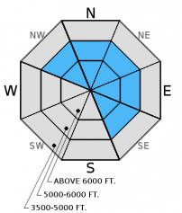
The avalanche danger is MODERATE in wind loaded terrain above 5000 feet. Overnight, abnormally strong winds formed fresh wind slabs at mid and upper elevations and these will continue to form throughout the day. Carefully evaluate recent windslabs before committing to a slope. In all other terrain the danger is LOW. Continue to practice safe travel techniques.

2. Moderate
?
Above 6500 ft.
2. Moderate
?
5000-6500 ft.
1. Low
?
3500-5000 ft.
- 1. Low
- 2. Moderate
- 3. Considerable
- 4. High
- 5. Extreme
-
Type ?
-
Aspect/Elevation ?

-
Likelihood ?CertainVery LikelyLikelyPossible
 Unlikely
 -
Size ?HistoricVery LargeLargeSmall

Wind speeds increased across our advisory area overnight and blustery conditions should be expected throughout the day. These light to moderate winds, combined with moderate to strong gusts, continue to drift recent snow and form fresh windslabs on leeward slopes and cross-loaded gullies. In some areas recent windslabs may have formed on a preserved layer of surface hoar making them more sensitive. With the abnormally brisk winds we are receiving be aware that fresh wind slabs could be forming lower on upper elevation terrain than what we are used to seeing. Despite minimal recent snowfall at mid-elevations strong wind gusts could be cross loading terrain features at this elevation. Continue to carefully evaluate wind loaded terrain at mid and upper elevations. Look for rounded pillows of wind drifted snow on leeward sides of ridges and cross-loaded areas in gullies at both mid and upper elevations.
-
Type ?
-
Aspect/Elevation ?

-
Likelihood ?CertainVery LikelyLikelyPossible
 Unlikely
 -
Size ?HistoricVery LargeLargeSmall

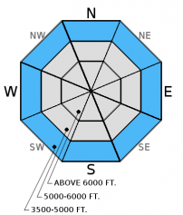
Recent rain at low elevations, combined with temperatures that have stayed above freezing for most of the past 2 days, have left us with a wet snow surface. It may be possible to trigger a wet loose avalanche on steep slopes at low elevations today. These slides will be small but can be consequential if you are knocked off your feet or machine.
Glide Cracks: As our mid winter snowpack transitions into a spring snowpack glide cracks are beginning to form. On Monday we observed a recently formed glide crack in the Kimmerly Basin area of the southern Whitefish Range, and others have reported isolated areas with glide cracks (observation). Glide avalanches are notoriously difficult to predict. It is best to simply avoid slopes with glide crack present (photo).
Persistent Slab: This season we dealt with an ever evolving persistent slab problem associated with widespread rain crusts and weak snow surrounding these crusts. As time has passed so has our concern with some of these rain crusts. Currently, we are still tracking the strength of the snow around the January 28 and February 14 crusts. The Valentine's Day crust now has 1.5-3 feet of snow sitting on top of it. In recent observations we found a thin layer of facets above this crust. Keep in mind that even small avalanches can step down into this deeper layer.
Sunday: Skiers in Cascade Creek in the Flathead Range noted a 1 inch thick surface crust to 6000 feet. They reported good skiing above that and "interesting" skiing at low elevations.
Saturday: Erich was instructing an avalanche class in the Ghoulie Point area in the southern Whitefish Range. He noted active windloading along the ridgelines and surface hoar that was preserved and buried beneath 1-2 inches of new snow. Participants in the class also noted surface hoar in the area. Stability tests produced variable fractures in the upper snowpack without propagation(observation). Mark and Guy traveled to the Napa Point area in the Swan Range and noted the snow level was at 5900 feet and the area picked up 4 inches of dense snow above that. They also had minimal results in stability tests (observation).
Friday: Skiers in Rescue Creek in the Flathead Range witnessed large loose, wet avalanches on sunny slopes (observation). Skiers east of Marias Pass in the Flathead Range found variable snow conditions and noted strong winds and active wind drifting (observation). Erich was instructing an avalanche class in the southern Whitefish Range and observed small, loose wet avalanches (photo) and noted widespread surface hoar formation. Skiers on Skookoleel Ridge in the southern Whitefish Range found large surface hoar on multiple aspects that remained preserved through the heat of the day. They also observed large cornices that showed signs of weakening due to rising temperatures (observation).
Thursday: We skied into Wahoo Creek in the Flathead Range. With nearly perfect visibility we could see many of the surrounding peaks and noted recently wind loaded and cross loaded slopes, as well as large cornices along leeward ridgelines. The snow surface was moist by afternoon on sunny slopes and we saw a few small, loose, wet avalanches and rollerballs. It was interesting that as we skied into mid-elevation terrain that the recent wind slabs were more firm and slightly more reactive than up high. Skiers touring from Ouzel Peak to Skiumah Creek also in the Flathead Range found variable ski conditions and surface hoar forming on multiple aspects but variable in distribution (observation).
Wednesday: Skiers in the southern Whitefish Range reported widespread surface hoar development, new glide cracks that have formed and minimal solar affect on sunny aspects (observation, observation).
Visit our Observations page and our You Tube channel for more observations from the entire season.
Thanks to everyone for submitting observations. They are extremely useful and could help save lives.
HOW TO SUBMIT OBSERVATIONS:
Email: [email protected]
Call and leave a message: 406.387.3821
You can also submit quick observations via text: 406.241.4571 (FAC mobile)
OR
Submit Snowpack Observations: http://www.flatheadavalanche.org/node/add/snowobs
Submit Avalanche Observations: http://www.flatheadavalanche.org/node/add/avyobs
A relatively warm weak disturbance entered our area last night producing windy conditions with only minimal moisture. In the past 24 hours we picked up a measly 0-2 inches of snow. However, winds were out of the west-southwest at 15-30 mph with gusts from 30-65 mph! The 65 mph gust was recorded at Hornet in the northern Whitefish Range with a 57 mph gust recorded at the notoriously windy Snowslip weather station in southern Glacier Park (John F. Stevens Canyon). Currently, temperatures above 6000 feet are 19º-27ºF and winds are out of the southwest 8-27 mph with gusts from 18-50 mph. Today should see light snow showers with temperatures in the upper 20s to the low-30s, and winds will blow out of the west-southwest at 20-30 mph with maximum gusts along ridgelines between 32-53 mph.
| 0600 temperature: | 26-33 deg. F. |
| Max. temperature in the last 24 hours: | 32-39 deg. F. |
| Average wind direction during the last 24 hours: | WSW |
| Average wind speed during the last 24 hours: | 5-15 mph |
| Maximum wind gust in the last 24 hours: | 24-40 mph |
| New snowfall in the last 24 hours: | 1-3 inches |
| Total snow depth: | 74-95 inches |
This advisory applies only to backcountry areas outside established ski area boundaries. This advisory describes general avalanche conditions and local variations always occur. This advisory expires at midnight on the posted day unless otherwise noted. The information in this advisory is provided by the USDA Forest Service who is solely responsible for its content.


