| Tuesday | Tuesday Night | Wednesday | |
|---|---|---|---|
| Cloud Cover: | High pressure building | High pressure | High pressure continuing |
| Temperatures: | 30-41 deg. F. | 9-18 deg. F. | 31-40 deg. F. |
| Wind Direction: | SW | SSW | SSW |
| Wind Speed: | 5-9 gusts 20 | 3-5 | 3-4 |
| Snowfall: | 0 in. | 0 in. | 0 in. |
| Snow Line: |
Whitefish Range
Swan Range
Flathead Range and Glacier National Park
How to read the forecast
Lingering wind slabs remain as our primary avalanche concern today with increasing temperatures and solar input expected to weaken the surface snow. The avalanche danger is MODERATE on all slopes above 5000 feet. Human triggered avalanches are possible and careful evaluation of snow and terrain is recommended. Below 5000 feet the danger is LOW.

2. Moderate
?
Above 6500 ft.
2. Moderate
?
5000-6500 ft.
1. Low
?
3500-5000 ft.
- 1. Low
- 2. Moderate
- 3. Considerable
- 4. High
- 5. Extreme
-
Type ?
-
Aspect/Elevation ?
-
Likelihood ?CertainVery LikelyLikelyPossible
 Unlikely
 -
Size ?HistoricVery LargeLargeSmall

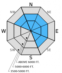
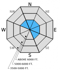
The Friday/Saturday storm brought abundant low density snow which was easily transported by moderate to strong winds. Recently formed wind slabs continue to gain strength but lingering instabilities remain. Today, it will still be possible to trigger a wind slab avalanche, especially in upper elevation terrain. Also, pay attention to cross-loaded terrain features that can exist well below the ridgeline. Look for rounded pillows of wind drifted snow on leeward sides of ridges and cross-loaded areas in gullies at both mid and upper elevations. Carefully evaluate all wind loaded terrain before committing to a slope.
-
Type ?
-
Aspect/Elevation ?
-
Likelihood ?CertainVery LikelyLikelyPossible
 Unlikely
 -
Size ?HistoricVery LargeLargeSmall

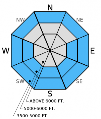
With high pressure building over our area this week the wet loose avalanche problem will increase. Today's forecasted high temperatures and solar input should affect the snow quality on all aspects at lower elevations and sunny aspects at mid elevations. Look for rapidly deteriorating conditions on sun exposed slopes. Early indicators that the surface snow is becoming unstable are roller balls forming on steep cut banks, or the snow surface becoming moist. It is important to pay attention to these changing conditions and to move into more shaded terrain. This is an easily manageable problem!
-
Type ?
-
Aspect/Elevation ?
-
Likelihood ?CertainVery LikelyLikelyPossible
 Unlikely
 -
Size ?HistoricVery LargeLargeSmall

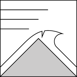
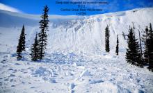
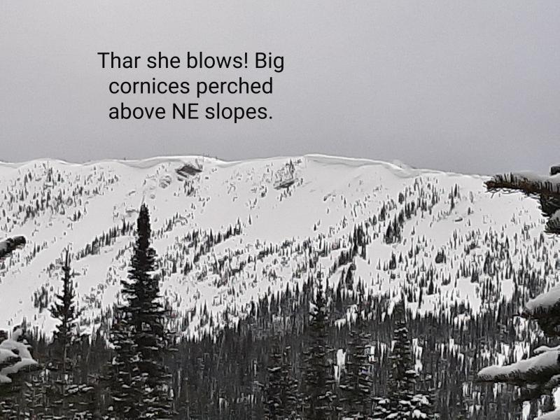
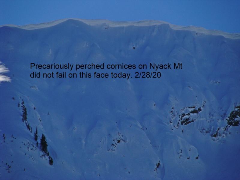
Substantial recent snow and wind has formed large cornices throughout our advisory area. These cornices can fail naturally during development or during periods of warming. The weight of a cornice failure can trigger wind, storm or persistent slab avalanches on the slope below. A large avalanche in the Lost Johnny drainage of the northern Swan Range this weekend is a good example of this (observation). With sunshine and warming temperatures on tap for the remainder of the work week cornices will weaken and cornice failure will be possible.
Persistent slab: This season we have dealt with an ever evolving persistent slab problem associated with widespread rain events. The end result of these events is an obvious rain crust with weak snow either on top of and/or below this layer. As time has passed so has our concern with some of these rain crusts. Currently, we are still tracking the strength of the snow around the January 28 and February 14 crusts. The Valentine's Day crust now has 1.5-3 feet of snow sitting on top of it. In recent observations we found a thin layer of facets above this crust. While it took hard force to initiate fracture, it propagated across the column in our stability tests on Thursday (video). Keep in mind that even small avalanches can step down into this deeper layer.
Glide cracks: As our mid winter snowpack transitions into a spring snowpack we need to be aware of glide crack formation. On Monday we observed a recently formed glide crack in the Kimmerly Basin area of the southern Whitefish Range. Glide crack failure is notoriously difficult to predict. It is wise to avoid slopes with obvious glide crack development (photo).
Monday: We traveled to Kimmerly Basin in the southern Whitefish Range where we found cohesive snow on wind loaded aspects. While skiing on this snow we observed localized cracking and were able to initiate small wind slab avalanches. We also noted large cornice development with numerous small cornice failures and a large glide crack (observation). Snowmobile observers traveled to Red Meadow in the northern Whitefish Range and Werner Peak in the southern Whitefish Range. They found evidence of recent wind loading and wind slab avalanches (observation).
Sunday: Snowmobilers in the Lost Johnny drainage of the northern Swan Range noted a large natural slab avalanche that appears to have been triggered by a cornice fall (observation). Skiers in Spider Bowl in the northern Swan Range noted lots of sluffing of the new snow on steep upper elevation slopes, southerly aspects becoming sun affected as the day progressed and only minimal new snow on a crust at 5000 feet. Skiers in the Marion Lake area of the Flathead Range reported south facing slopes being sun affected with a 1/2 inch thick crust by late afternoon but good snow quality and no signs of instability while skiing north aspects.
Saturday: There were two close calls in the advisory area. A skier was caught in a thin slab avalanche adjacent to the Whitefish Mountain Resort boundary and was carried an estimated 500 feet. This individual triggered the slide 2 or 3 turns into their run from a ridgeline. Fortunately only minor injuries were sustained. A snowboarder in the Cascadilla Drainage in the Flathead Range triggered a slab avalanche and was able to ride out (observation).
Snowmobile observers were in the Skyland area in the Flathead Range and noted 10-12 inches of new snow. Wind was drifting the snow, but only building very soft slabs. They found the Valentine's (2/14) crust 1.5 feet from the surface that fractured and propagated with moderate force in stability tests. Additionally, there was a thick rain crust formed in late January with underlying weak snow that also fractured and propagated with hard force. Skiers on Baldhead Mountain in the Flathead Range found 16-18 inches of storm snow (observation). Skiers on Paola ridge reported steady moderate winds that drifted snow throughout the day and periods of heavy snowfall. On a few short test slopes they observed shooting cracks (observation). Skiers in Dickey Creek, also in the Flathead Range found 12 inches of new snow at upper elevations and noted sluffing and shooting cracks on their descent. Skiers in the Marion Lake area observed wind drifting the snow along ridgelines and cross-loading mid-slopes. They also noted obvious signs of instability like shooting cracks (observation).
Visit our Observations page and our You Tube channel for more observations from the entire season.
Soft slab potenitally triggered by cornice fall in Lost Johnny, Swan Range. Above photos courtesy of: Kilee Stevens
Thanks to everyone for submitting observations. They are extremely useful and could help save lives.
HOW TO SUBMIT OBSERVATIONS:
Email: [email protected]
Call and leave a message: 406.387.3821
You can also submit quick observations via text: 406.241.4571 (FAC mobile)
OR
Submit Snowpack Observations: http://www.flatheadavalanche.org/node/add/snowobs
Submit Avalanche Observations: http://www.flatheadavalanche.org/node/add/avyobs
High pressure moved into our area overnight and will continue to strengthen over the next few days. As of 6:00 a.m.temperatures above 6000 feet range from 14º-23º F and winds are out of the west-southwest at 6-15 mph gusting to 21 mph. Today should see partly sunny skies with temperatures warming to the upper 20s to low 30s. Winds will be light out of the west southwest at 5-10 mph with moderate gusts in the 20s.
| 0600 temperature: | 14-23 deg. F. |
| Max. temperature in the last 24 hours: | 19-28 deg. F. |
| Average wind direction during the last 24 hours: | SW |
| Average wind speed during the last 24 hours: | 5-15 mph |
| Maximum wind gust in the last 24 hours: | 21-33 mph |
| New snowfall in the last 24 hours: | 0 inches |
| Total snow depth: | 77-100 inches |
This advisory applies only to backcountry areas outside established ski area boundaries. This advisory describes general avalanche conditions and local variations always occur. This advisory expires at midnight on the posted day unless otherwise noted. The information in this advisory is provided by the USDA Forest Service who is solely responsible for its content.


