| Saturday | Saturday Night | Sunday | |
|---|---|---|---|
| Cloud Cover: | Snow showers. Locally heavy snow bands possible at times. | Lingering showers. | Partial clearing. |
| Temperatures: | 28-38 deg. F. | 14-22 deg. F. | 29-38 deg. F. |
| Wind Direction: | W-SW | W-SW | S-SW |
| Wind Speed: | 16-22 gusts 33-41 | 7-12 gusts 25 | 4-5 |
| Snowfall: | 2-3 in. | 0 in. | 0 in. |
| Snow Line: |
Swan Range
How to read the forecast
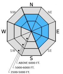
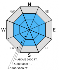
Continued strong winds combined with new snow overnight added depth to sensitive wind slabs. Human triggered avalanches are likely in wind loaded areas above 6000 feet and possible in more sheltered areas. Natural avalanches are also possible. Cautious route finding and conservative decision making are essential. Weak snow above the Valentine's crust that is 1.5-2.5 feet deep also requires careful evaluation. See Whitefish Range advisory and Flathead Range advisory.

3. Considerable
?
Above 6500 ft.
2. Moderate
?
5000-6500 ft.
1. Low
?
3500-5000 ft.
- 1. Low
- 2. Moderate
- 3. Considerable
- 4. High
- 5. Extreme
-
Type ?
-
Aspect/Elevation ?

-
Likelihood ?CertainVery LikelyLikelyPossible
 Unlikely
 -
Size ?HistoricVery LargeLargeSmall

Yesterday, we found new windslabs up to a foot thick. They continued to show signs of instability by cracking as we traveled above them. With the additional snow and continued strong winds overnight, these slabs will be thicker and remain sensitive to human triggers. With the strength of the wind over the past few days it is also important to keep an eye out for cross-loaded terrain features that can exist well below the ridgeline. Look for rounded pillows of wind drifted snow on leeward sides of ridges and cross-loaded areas in gullies at both mid and upper elevations, and carefully evaluate all wind loaded terrain.
-
Type ?
-
Aspect/Elevation ?

-
Likelihood ?CertainVery LikelyLikelyPossible
 Unlikely
 -
Size ?HistoricVery LargeLargeSmall

The Valentine's Day (2/14) rain crust now has 1.5-2.5 feet of snow sitting on top of it. In most recent observations we found a thin layer of facets above this crust. While it took hard force to initiate fracture, it propagated across the column in our stability tests on Thursday (video). Since this layer is relatively new and there have been no observations aside from our own the past few days, there is uncertainty with how reactive it may be in many locations. As mentioned in the weather section, over the past week we have seen snow water equivalents in excess of 3.0 inches which is a lot of stress for the strongest of layers. So, the best strategy is to treat this layer with caution on all slopes and dig into the snow to assess its reactivity. The slab above this crust will be much thicker in wind loaded areas.
-
Type ?
-
Aspect/Elevation ?

-
Likelihood ?CertainVery LikelyLikelyPossible
 Unlikely
 -
Size ?HistoricVery LargeLargeSmall

With the continued possibility of localized heavy snow, pay attention to thin storm slabs that become reactive due to precipitation intensity. The effect of small avalanches can can be amplified if traveling in or near terrain traps like trees, cliffs, and narrow gullies. Remember that small avalanches add rapid stress to deeper weak layers and can step down.
Friday: We headed to Noisy Basin in the Swan Range. Strong winds continued on the ridgelines, but there was minimal drifting of snow due to scouring on windward sides of ridges. Recent wind slabs were not as sensitive as Erich found the previous day, but still showed signs of instability as they cracked as we traveled the ridgeline. We also noted very large cornices growing in the area. We also found the Valentine's rain crust 1-2 feet from the surface with a thin layer of weak snow above (photo). This layer fractured in stability tests with moderate force (observation). Skiers on Skookoleel Ridge in the southern Whitefish Range found 4-6 inches of recent snow and evidence of strong, recent winds (observation).
Thursday: Erich spent a soggy day in the Marion and Dickey Creek drainages where they observed strong winds and wind loading, touchy wind slabs, and a reactive slab sitting on top of the 2/14 rain crust (video and observation).
Wednesday: Mark and Erich toured in the Canyon Creek/Skookoleel Creek area where they found previous wind loading, large cornices, and a new rain crust formed in mid-February (observation).
Monday: BNSF Avalanche Safety reported a slab avalanche on Nyack Mountain in the Flathead Range with a crown depth estimated at 3-4 feet deep. Active wind loading was observed at upper elevations. Forest Service snowmobile staff riders rode into the Canyon Creek drainage of the southern Whitefish Range and observed rollerballs, wet loose avalanche activity at mid elevations and wind loading at the ridges. In their snowpit they found a decomposing surface hoar layer 14" below the snow surface (observation).
Visit our Observations page and our You Tube channel for more observations from the entire season.
Thanks to everyone for submitting observations. They are extremely useful and could help save lives.
HOW TO SUBMIT OBSERVATIONS:
Email: [email protected]
Call and leave a message: 406.387.3821
You can also submit quick observations via text: 406.241.4571 (FAC mobile)
OR
Submit Snowpack Observations: http://www.flatheadavalanche.org/node/add/snowobs
Submit Avalanche Observations: http://www.flatheadavalanche.org/node/add/avyobs
Another wave of precipitation moved through the area beginning yesterday evening. In the past 24 hours we picked up another 3-5 inches of snow and 0.2-0.8 inches of snow water equivalent. Moderate to strong winds continued out of the west and southwest. Currently, temperatures above 6000 feet range from 21º-28º F, and winds are out of the southwest at 7-16 mph with gusts to 26 mph. Today expect showers to continue through the afternoon. These showers could be heavy at times. Temperatures should stay in the upper 20s to low 30s. Winds will blow out of the west and southwest at 5-15 mph with gusts in the 30s.
The past 7 days have been relatively active with precipitation (both rain and snow). Most SNOTEL sites across the advisory area around 6000 feet picked up 3.1 to 3.7 inches of snow water equivalent in this period. With rain, snow, and warming temperatures, a myriad of avalanche problems can exist.
| 0600 temperature: | 21-28 deg. F. |
| Max. temperature in the last 24 hours: | 25-32 deg. F. |
| Average wind direction during the last 24 hours: | SW |
| Average wind speed during the last 24 hours: | 5-15 mph |
| Maximum wind gust in the last 24 hours: | 26-55 mph |
| New snowfall in the last 24 hours: | 3-5 inches |
| Total snow depth: | 78-99 inches |
This advisory applies only to backcountry areas outside established ski area boundaries. This advisory describes general avalanche conditions and local variations always occur. This advisory expires at midnight on the posted day unless otherwise noted. The information in this advisory is provided by the USDA Forest Service who is solely responsible for its content.


