| Saturday | Saturday Night | Sunday | |
|---|---|---|---|
| Cloud Cover: | Snow at lowering snow levels. | Increasing snow. | Snow. |
| Temperatures: | 31-43 deg. F. | 23-30 deg. F. | 32-42 deg. F. |
| Wind Direction: | W-SW | W-SW | W-SW |
| Wind Speed: | 11-16 gusts 24-32 | 11-15 gusts 22-29 | 11-15 gusts 29 |
| Snowfall: | 1-3 in. | 1-3 in. | 1-4 in. |
| Snow Line: |
Whitefish Range
Swan Range
Flathead Range and Glacier National Park
How to read the forecast
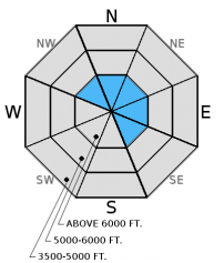
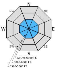
New snow at upper elevations accompanied by moderate to strong winds created fresh wind slabs. The avalanche danger is CONSIDERABLE on wind loaded slopes above 6000 feet. Human triggered avalanches are likely. The danger is MODERATE at mid elevations, and LOW below 5000 feet. Evaluate the snowpack and terrain carefully before committing to any slope. Persistent slab avalanches are possible where buried surface hoar and faceted snow near crusts 1 to 2 feet below the surface exist.

3. Considerable
?
Above 6500 ft.
2. Moderate
?
5000-6500 ft.
1. Low
?
3500-5000 ft.
- 1. Low
- 2. Moderate
- 3. Considerable
- 4. High
- 5. Extreme
-
Type ?
-
Aspect/Elevation ?

-
Likelihood ?CertainVery LikelyLikelyPossible
 Unlikely
 -
Size ?HistoricVery LargeLargeSmall

Since most of the precipitation in the past 24 hours fell as rain at our SNOTEL sites and Remote Weather Stations there is some uncertainty in the amount of snow we picked up in the upper elevations. Moderate to strong winds drifted the new snow and created slabs on the leeward sides of ridgelines and cross-loaded mid-slope terrain features. With additional snow accompanied by moderate winds expected today these slabs will get thicker as the day progresses. In some locations these fresh wind slabs may sit on top of surface hoar formed earlier in the week. If traveling at upper elevations carefully evaluate wind loaded terrain before committing to a slope. In more sheltered terrain in upper elevations look for thin storm slabs formed in the past 24 hours. Remember that areas not affected by the wind are the most likely to harbor recently buried surface hoar so even thin, soft storm slabs may be reactive today.
-
Type ?
-
Aspect/Elevation ?

-
Likelihood ?CertainVery LikelyLikelyPossible
 Unlikely
 -
Size ?HistoricVery LargeLargeSmall

Buried surface hoar and faceted snow about 8-24 inches from the surface exists. In upper elevation locations this has become a hard slab in many locations, and is increasingly more difficult to trigger. However, recent natural avalanches triggered by cornice fall within the past week show this is a low probability/high consequence scenario that should be treated with respect. A couple of these avalanches propagated far and wide (photo 1, photo 2). The additional stress put on these layers with new snow and wind drifted snow may cause them to become more reactive. These hard slabs are more likely to exist on previously wind loaded slopes. This weak layer is also spotty in distribution making it tricky to identify.
Weak snow surrounding the January 28 and January 17 rain crusts also exists 1.5-2.5 feet from the surface. Recent stability tests suggest that these weak layers are gaining strength, but a large load like a cornice fall or snowmobiles could be enough to awaken these layers. It still remains important to perform site specific snowpack evaluation due to the variability. Dig in the snow and do a stability test. Where they are present and there is any question about stability choose conservative terrain to ski or ride on. Avoid areas where you are more likely to affect these layers like in shallow snow and in steep, rocky areas. Avalanche professionals in southern Glacier Park experienced a collapse Thursday on a shallow snowpack on a southeast aspect; a clear sign of instability.
NOTE: If you are headed out today, it would be a good day to see how the recently formed surface hoar is doing. Rain will likely destroy the surface hoar at lower elevations, and the previous day's sunshine probably destroyed much of it on sunny aspects. However, there could be some lurking on shaded mid- and upper elevation slopes. Mentally mapping this layer before it gets buried is wise as it has the potential to become a problem in the future.
Friday: We were in McGinnis Creek in the southern Whitefish Range and found a wet snow surface up to at least 6000 feet. We noted a layer of decomposing buried surface hoar that was 6-10 inches from the surface that fractured in stability tests (observation).
Thursday: BNSF avalanche safety noted a moist snowpack, warm temperatures, and experienced collapsing on a southeast aspect with a shallow snowpack (observation). They also observed a cornice triggered slab avalanche on Mt. Cameahwait in the Flathead Range (photo), but are uncertain of the date of occurrence. Glacier Park rangers observed recent wet avalanche activity on the south aspects of Mt. Stanton yesterday (observation). Snowmobilers in Canyon Creek in the southern Whitefish Range also observed recent loose, wet avalanches (photo).
Wednesday: My partner and I found wet snow on sunny aspects with numerous small, wet loose sluffs (observation). We, along with other professionals and skiing parties in the southern Whitefish Range, observed widespread surface hoar formation (video, observations). Snowbikers in the Stryker Ridge area in the Whitefish Range also reported rollerballs, wet surface snow, and large surface hoar formation. A Two Bear Air Rescue pilot also observed cornice triggered recent wet, loose avalanche activity in the Swan Range on sunny aspects during a recent flight.
Tuesday: We traveled to the Marion Lake area of the Flathead Range. We noted moist surface snow on sunny aspects with rollerballs and small point releases occurring throughout the day. Lingering wind slabs were present on leeward slopes. These wind slabs fractured but did not propagate in stability tests. We also were able to identify 3 natural wind slab avalanches from the weekend (observation).
Monday: Snowmobile rangers rode into the Mission Mountains just outside the advisory area and noted evidence of the recent wind event at all elevations. They found 2 layers of surface hoar in a north facing pit and also observed warm conditions and rollerballs/pinwheels at all elevations (observation).
Visit our Observations page and our You Tube channel for more observations from the entire season.
Thanks to everyone for submitting observations. They are extremely useful and could help save lives.
HOW TO SUBMIT OBSERVATIONS:
Email: [email protected]
Call and leave a message: 406.387.3821
You can also submit quick observations via text: 406.241.4571 (FAC mobile)
OR
Submit Snowpack Observations: http://www.flatheadavalanche.org/node/add/snowobs
Submit Avalanche Observations: http://www.flatheadavalanche.org/node/add/avyobs
Warm temperatures yesterday resulted in most of the precipitation falling as rain up to at least 6500 feet. We picked up between 0.3-0.7 inches of snow water equivalent and recorded 0-3 inches of snow. A cold front passing through the area today will lower snow levels so we should see an additional few inches of snow. Winds picked up early this morning and are blowing out of the southwest at 5-19 mph with gusts from 13-28 mph. Currently mountain temperatures range from 26º-33º F. Today, expect temperatures in the upper 20s to low 30s with winds out of the west-southwest at 10-15 mph with gusts in the 30s on the high ridgelines.
| 0600 temperature: | 26-33 deg. F. |
| Max. temperature in the last 24 hours: | 32-37 deg. F. |
| Average wind direction during the last 24 hours: | SW |
| Average wind speed during the last 24 hours: | 5-15 mph |
| Maximum wind gust in the last 24 hours: | 15-39 mph |
| New snowfall in the last 24 hours: | 0-3 inches |
| Total snow depth: | 59-88 inches |
This advisory applies only to backcountry areas outside established ski area boundaries. This advisory describes general avalanche conditions and local variations always occur. This advisory expires at midnight on the posted day unless otherwise noted. The information in this advisory is provided by the USDA Forest Service who is solely responsible for its content.


