| Saturday | Saturday Night | Sunday | |
|---|---|---|---|
| Cloud Cover: | Snow tapering, continued strong wind. | Lingering, isolated snow showers | Building high pressure. |
| Temperatures: | 26-36 deg. F. | 15-24 deg. F. | 27-35 deg. F. |
| Wind Direction: | W | W | W |
| Wind Speed: | 20-24 gusts 38-43 | 4-12 gusts 20-30 | 6-9 |
| Snowfall: | 1-3 in. | 0-1 in. | 0 in. |
| Snow Line: |
Whitefish Range
Swan Range
Flathead Range and Glacier National Park
How to read the forecast
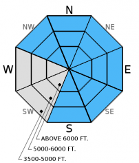
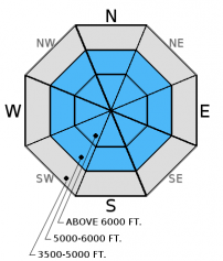
Strong winds and recent snow formed slabs over a layer of buried surface hoar. Additionally, settlement and warm temperatures likely formed a cohesive slab in more protected areas. The avalanche danger is CONSIDERABLE above 5000 ft. Human triggered avalanches are likely and dangerous conditions exist particularly in wind loaded terrain. The added load also stresses deeper weak layers surrounding a variety of crusts in the snowpack. Careful snowpack evaluation, cautious route-finding, and conservative decision making are essential.

3. Considerable
?
Above 6500 ft.
3. Considerable
?
5000-6500 ft.
2. Moderate
?
3500-5000 ft.
- 1. Low
- 2. Moderate
- 3. Considerable
- 4. High
- 5. Extreme
-
Type ?
-
Aspect/Elevation ?

-
Likelihood ?CertainVery LikelyLikelyPossible
 Unlikely
 -
Size ?HistoricVery LargeLargeSmall

Moderate to strong southwest winds over the past 48 hours formed fresh wind slabs and dangerous avalanche conditions. These wind slabs remain sensitive and exist at all elevations (photo). These slabs formed over a recently buried layer of surface hoar (formed 2/3), and due to cross-loading from strong winds exist on many aspects. Avalanches releasing on surface hoar have the potential to propagate far and wide. I expect wind slabs to remain sensitive today to human triggering. Look for obvious signs of instabilty like shooting cracks, whumpfing, and recent avalanche activity. These slabs could be up to 2.5 feet thick. Look for convex pillows of wind drifted snow on the lee sides of ridges and other cross-loaded terrain. Even unsuspecting slopes could harbor a wind slab today. Carefully evaluate all wind loaded terrain before traveling on or underneath the slope. The potential to trigger shallow storm slabs remains today on all aspects. These avalanches could break at the old/new snow interface especially since this new snow is accumulating on top of surface hoar.
-
Type ?
-
Aspect/Elevation ?

-
Likelihood ?CertainVery LikelyLikelyPossible
 Unlikely
 -
Size ?HistoricVery LargeLargeSmall

In addition to the freshly buried surface hoar now about 6 inches to a foot from the surface, there are a variety of crusts surrounded by weak faceted snow within the top 4 feet of our snowpack. Recent stabilty tests produced variable results on both the Jan. 28 and Jan. 17 rain crusts, and some tests show that these layers continue to fracture and propagate. This illustrates that it is possible to trigger an avalanche on these layers. Recent new snow will stress these layers even more, and, combined with a human trigger, could be just enough of a load to move past the tipping point. Wind slab avalanches also have the potential to step down to these more deeply buried weak layers.
The Jan. 28 rain crust is located about 1.5 to 2 feet from the surface with the thin Jan. 17 crust about 2-2.5 feet down. The facets and surface hoar below the January 12 rain crust have been largely dormant the past 12 days. The only way to know if these layers are present and reactive is to dig into the snow and perform stability tests. You are most likely to trigger deeper instabilities in areas with shallow snow where they are closer to the surface, and in steep, rocky terrain. A rapid stress to these layers like cornice fall, smaller avalanches, or multiple machines on a slope could also awaken them.
Recent strong winds helped grow our local cornice population in size and quantity. Treat all cornices as suspect and stay far back from the edge. Cornice fall on slopes below are likely to trigger at least wind slabs today and potenitally even deeper instabilities.
The final report for the 1/23/2016 avalanche fatality in Swede Creek in the Whitefish Range is complete and located here: http://www.flatheadavalanche.org/sites/default/files/20160124_swedecreekavalaccidentreport_final.pdf.
Friday: Skiers in Crystal Creek/Stanton Lake in the Flathead Range intentionally triggered a windslab from the ridgeline (photo). They also noted active windloading forming slabs thicker than 2 feet deep (observation). Skiers on Snowshed Mountain also in the Flathead Range observed light winds with minimal drifting due to scoured windward slopes. They did note evidence of recent wind loading as knee deep soft slabs had formed on leeward slopes. Stability tests produced fractures with hard force on weak snow surrounding crusts 1.5-2 feet deep. They did not observe recently formed buried surface hoar in this location (observation). Snowmobilers in the 6-Mile area in the Swan Range noted substantial recent windloading. They did not see recent avalanche activity, but did experience other obvious signs of instability like cracking and collapsing (whumphing).
Thursday: Erich and I rode into Doris Ck. yesterday and were a bit suprised to see how much wind affected snow existed at elevations below 5000 ft. While the slabs weren't terribly large (6-10 inches deep), this clearly shows that they are thicker at mid and upper elevations. We also observed shooting cracks on small test slopes less than 35 degrees (observation, video). Skiers in the Essex Creek area of the Flathead Range also reported strong to extreme (>38 mph) winds with loose snow sluffs and shallow slabs on steep slopes as well (observation). Skiers in the Wahoo/Cascadilla area in the Flathead Range observed widespread cracking, shallow slabs at lower elevations, and signs of instability at all elevations as well.
Wednesday: Erich toured in Skookoleel and Lakalaho Creeks in the southern Whitefish Range yesterday where they found variable results in our numerous stability tests in a number of different pit locations (video, observation). They also found 3-5 mm surface hoar that formed Tuesday night. Skiers in the Middle Fork of the Flathead Range also observed surface hoar and a few layers in the upper snowpack that produced fracture in their stability tests (observation).
Visit our Observations page and our You Tube channel for more observations from the entire season.
Thanks to everyone for submitting observations. They are extremely useful and could help save lives.
HOW TO SUBMIT OBSERVATIONS:
Email: [email protected]
Call and leave a message: 406.387.3821
You can also submit quick observations via text: 406.241.4571 (FAC mobile)
OR
Submit Snowpack Observations: http://www.flatheadavalanche.org/node/add/snowobs
Submit Avalanche Observations: http://www.flatheadavalanche.org/node/add/avyobs
We received less snow than expected overnight but the winds certainly delivered. In the past 24 hours most of the area only saw up to an inch of snow which is likely under-reported due to the strong winds. Flattop SNOTEL (just outside the advisory area) was the winner in terms of snow water equivalent recording 0.4 inches. The winds are the big story in the past 24 hours blowing out of the southwest at 10-20 mph with gusts between 31 and 64 mph. Hornet weather station reported average wind speeds of 34-43 mph in the past 2 hours and Logan Pass had gusts to 98 mph. Currently, mountain temperatures range from 25º-31º F, and winds are 10-43 mph with gusts to 64 mph out of the southwest. Snow should taper this morning though showers will remain possible through out the day. Temperatures are expected to continue to fall with a passing cold front. Winds will continue out of the west and southwest from 20-30 mph with gusts in the 50s and 60s.
| 0600 temperature: | 25-31 deg. F. |
| Max. temperature in the last 24 hours: | 25-31 deg. F. |
| Average wind direction during the last 24 hours: | SW |
| Average wind speed during the last 24 hours: | 10-20 mph |
| Maximum wind gust in the last 24 hours: | 31-64 mph |
| New snowfall in the last 24 hours: | 0-1 inches |
| Total snow depth: | 66-97 inches |
This advisory applies only to backcountry areas outside established ski area boundaries. This advisory describes general avalanche conditions and local variations always occur. This advisory expires at midnight on the posted day unless otherwise noted. The information in this advisory is provided by the USDA Forest Service who is solely responsible for its content.


