| Friday | Friday Night | Saturday | |
|---|---|---|---|
| Cloud Cover: | Brief break from storms with possible light snow. | Snow and wind. | Tapering snow and wind through the day. |
| Temperatures: | 30 to 38 deg. F. | 23 to 32 deg. F. | 27 to 36 deg. F. |
| Wind Direction: | West-Southwest | West-Southwest | West-Southwest |
| Wind Speed: | 10-15 mph with gusts to 35 mph. | 15-20 mph with gusts to 45 mph. | 18-25 mph with gusts to 45 mph. |
| Snowfall: | 0-1 in. | 2-4 in. | 2-4 in. |
| Snow Line: |
Whitefish Range
Swan Range
Flathead Range and Glacier National Park
How to read the forecast
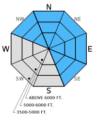
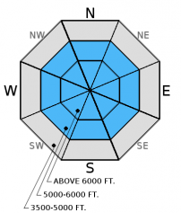
The avalanche danger is CONSIDERABLE above 5000 ft. Strong winds and new snow formed slabs over a recently formed layer of surface hoar. Recent observations indicate these slabs are sensitive to human triggering. This recent snow also stresses deeper weak layers surrounding a variety of crusts located 1.5 to 4 feet from the snow surface. Human triggered avalanches are likely and dangerous conditions exist on wind loaded terrain. Careful snowpack evaluation, cautious route-finding, and conservative decision making are essential today.

3. Considerable
?
Above 6500 ft.
3. Considerable
?
5000-6500 ft.
2. Moderate
?
3500-5000 ft.
- 1. Low
- 2. Moderate
- 3. Considerable
- 4. High
- 5. Extreme
-
Type ?
-
Aspect/Elevation ?

-
Likelihood ?CertainVery LikelyLikelyPossible
 Unlikely
 -
Size ?HistoricVery LargeLargeSmall

Moderate to strong southwest winds over the past 36 hours formed fresh wind slabs and dangerous avalanche conditions. These wind slabs are sensitive and exist at all elevations (photo). These slabs formed over a recently buried layer of surface hoar (formed 2/3), and due to cross-loading from strong winds exist also exist on many aspects. Avalanches releasing on surface hoar have the potential to propagate far and wide. I expect wind slabs to remain sensitive today to human triggering. Look for obvious signs of instabilty like shooting cracks, whumpfing, and recent avalanche activity. These slabs could be up to 2.5 feet thick. Look for convex pillows of wind drifted snow on the lee sides of ridges and other cross-loaded terrain. Even unsuspecting slopes could harbor a wind slab today. Carefully evaluate all wind loaded terrain before traveling on or underneath the slope. Shallow storm slabs are also possible today on all aspects. These avalanches could break at the old/new snow interface especially since this new snow is accumulating on top of surface hoar.
-
Type ?
-
Aspect/Elevation ?

-
Likelihood ?CertainVery LikelyLikelyPossible
 Unlikely
 -
Size ?HistoricVery LargeLargeSmall

In addition to the freshly buried surface hoar now about 6 inches to a foot from the surface, there are a variety of crusts surrounded by weak faceted snow within the top 4 feet of our snowpack. Recent stabilty tests produced variable results on both the Jan. 28 and Jan. 17 rain crusts, and some tests show that these layers continue to fracture and propagate. This illustrates that it is possible to trigger an avalanche on these layers. Recent new snow will stress these layers even more, and, combined with a human trigger, could be just enough of a load to move past the tipping point. Wind slab avalanches also have the potential to step down to these more deeply buried weak layers.
The Jan. 28 rain crust is located about 1.5 to 2 feet from the surface with the thin Jan. 17 crust about 2-2.5 feet down. The facets and surface hoar below the January 12 rain crust have been largely dormant the past 12 days. The only way to know if these layers are present and reactive is to dig into the snow and perform stability tests. You are most likely to trigger deeper instabilities in areas with shallow snow where they are closer to the surface, and in steep, rocky terrain. A rapid stress to these layers like cornice fall, smaller avalanches, or multiple machines on a slope could also awaken them.
Recent strong winds helped grow our local cornice population in size and quantity. Treat all cornices as suspect and stay far back from the edge. Cornice fall on slopes below are likely to trigger at least wind slabs today and potenitally even deeper instabilities.
Warming temperatures reaching above freezing at lower elevations could produce both natural and human triggered loose snow sluffs today. These avalanches should be relatively small, but could be large enough to knock you off your feet. Even small avalanches can be impactful in high consequence terrain or terrain traps.
The final report for the 1/23/2016 avalanche fatality in Swede Creek in the Whitefish Range is complete and located here: http://www.flatheadavalanche.org/sites/default/files/20160124_swedecreekavalaccidentreport_final.pdf.
Thursday: Todd and I rode into Doris Ck. yesterday and were a bit suprised to see how much wind affected snow existed at elevations below 5000 ft. While the slabs weren't terribly large (6-10 inches deep), this clearly shows that they are thicker at mid and upper elevations. We also observed shooting cracks on small test slopes less than 35 degrees (observation, video). Skiers in the Essex Creek area of the Flathead Range also reported strong to extreme (>38 mph) winds with loose snow sluffs and shallow slabs on steep slopes as well (observation). Skiers in the Wahoo/Cascadilla area in the Flathead Range observed widespread cracking, shallow slabs at lower elevations, and signs of instability at all elevations as well.
Wednesday: My partner and I toured in Skookoleel and Lakalaho Creeks in the southern Whitefish Range yesterday where we found variable results in our numerous stability tests in a number of different pit locations (video, observation). We also found 3-5 mm surface hoar that formed Tuesday night. Skiers in the Middle Fork of the Flathead Range also observed surface hoar and a few layers in the upper snowpack that produced fracture in their stability tests (observation).
Tuesday: BNSF avalanche safety was near Running Rabbit Mountain in southern Glacier National Park. The main concern in their snowpit was the interface at a melt freeze crust about 3 feet from the snow surface (observation). Also on Tuesday, skiers in the northern Swan Range found a deep snowpack on a west-northwest aspect. Their stability tests and ski cutting showed instabilities confined to the surface snow (observation).
Monday: Mark traveled to Wahoo Creek in the Flathead Range where he found low density surface snow that was not adhering well to a rain crust formed January 28 (observation). Also on Monday, BNSF avalanche safety reported fracture and propagation requiring hard force in their stability tests. The layer of concern was facets/decomposing surface hoar resting on a melt freeze crust buried about 30 inches below the snow surface (video, observation). Skiers in Rescue Creek in the Flathead Range noted evidence of avalanche debris covered by recent snowfall.
Visit our Observations page and our You Tube channel for more observations from the entire season.
Thanks to everyone for submitting observations. They are extremely useful and could help save lives.
HOW TO SUBMIT OBSERVATIONS:
Email: [email protected]
Call and leave a message: 406.387.3821
You can also submit quick observations via text: 406.241.4571 (FAC mobile)
OR
Submit Snowpack Observations: http://www.flatheadavalanche.org/node/add/snowobs
Submit Avalanche Observations: http://www.flatheadavalanche.org/node/add/avyobs
Mountain weather stations had a bit of a rough time measuring snow depth yesterday due to strong winds redistributing the new snow. To normalize it, let's look at snow water equivalent. 0.4-0.6 inches of SWE accumulated through the storm with Flattop SNOTEL in GNP (just outside the advisory area) recording the most snow (9 inches). Today, we could see a couple of inches of new snow in the upper elevations before a warmer storm enters the region tonight bringing more snow above 4000 ft. and strong winds. Currently, temperatures above 6000 feet range from 18º-24º F, and winds are moving out of the southwest at 5-19 mph with gusts to 28 mph. Today, temperatures will range from the upper 20s to mid 30s F, and winds will be out of the southwest at 10-20 mph with gusts to 45 mph.
| 0600 temperature: | 18 to 24 deg. F. |
| Max. temperature in the last 24 hours: | 15 to 23 deg. F. |
| Average wind direction during the last 24 hours: | Southwest |
| Average wind speed during the last 24 hours: | 9-32 mph |
| Maximum wind gust in the last 24 hours: | 21-46 mph |
| New snowfall in the last 24 hours: | 0-3 inches |
| Total snow depth: | 69-99 inches |
This advisory applies only to backcountry areas outside established ski area boundaries. This advisory describes general avalanche conditions and local variations always occur. This advisory expires at midnight on the posted day unless otherwise noted. The information in this advisory is provided by the USDA Forest Service who is solely responsible for its content.


