| Thursday | Thursday Night | Friday | |
|---|---|---|---|
| Cloud Cover: | Snow. Moderate to strong winds. | Continued snow showers. | Lingering snow showers. |
| Temperatures: | 26 to 35 deg. F. | 19 to 26 deg. F. | 29 to 38 deg. F. |
| Wind Direction: | West-Southwest | West-Southwest | West-Southwest |
| Wind Speed: | 10-20 mph with gusts to 35 mph. | 10-15 mph with gusts to 30 mph. | 11-17 mph with gusts to 40 mph. |
| Snowfall: | 2-4 in. | 1-2 in. | 1-2 in. |
| Snow Line: |
Whitefish Range
Swan Range
Flathead Range and Glacier National Park
How to read the forecast
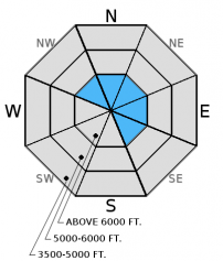
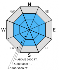
The avalanche danger is CONSIDERABLE above 5000 ft. New snow accompanied by moderate to strong winds will form wind slabs over a newly formed layer of surface hoar. This new snow will also stress deeper weak layers surrounding a variety of crusts located 1.5 to 4 feet from the snow surface. Human triggered avalanches are likely, particularly on wind loaded terrain. Careful snowpack evaluation, cautious route-finding, and conservative decision making are essential today.

3. Considerable
?
Above 6500 ft.
3. Considerable
?
5000-6500 ft.
2. Moderate
?
3500-5000 ft.
- 1. Low
- 2. Moderate
- 3. Considerable
- 4. High
- 5. Extreme
-
Type ?
-
Aspect/Elevation ?

-
Likelihood ?CertainVery LikelyLikelyPossible
 Unlikely
 -
Size ?HistoricVery LargeLargeSmall

Moderate to strong southwest winds today will form fresh wind slabs. I expect these wind slabs to be sensitive to human triggering today as they form over a layer of surface hoar. This setup has the potential for avalanches to propagate far and wide. We could also see natural wind slab avalanches in upper elevations. These slabs will form on leeward and cross-loaded slopes and could be up to 2 feet thick. This will add depth to already existing slabs sitting above the Jan. 28 rain crust and weak snow surrounding it. Cross loaded slopes have also developed thick wind slabs (video). Wind loaded slopes are relatively easy to identify. Look for smooth, rounded features and convex pillows on leeward slopes. Carefully evaluate all wind loaded terrain before committing to a slope.
This new snow will be heavier than recent snowfall especially as temperatures rise through the day, and shallow storm slabs are also possible today on all aspects. These avalanches could break at the old/new snow interface especially since this new snow is accumulating on top of surface hoar.
-
Type ?
-
Aspect/Elevation ?

-
Likelihood ?CertainVery LikelyLikelyPossible
 Unlikely
 -
Size ?HistoricVery LargeLargeSmall

There are a variety of crusts surrounded by weak faceted snow within the top 4 feet of our snowpack. Recent stabilty tests produced variable results on both the Jan. 28 and Jan. 17 rain crusts. However, some stability test results show that these layers continue to fracture and propagate. This illustrates that it is possible to trigger an avalanche on these layers. Today's new snow will stress these layers even more, and could be just enough of a load to move past the tipping point.
The Jan. 28 rain crust is located about 1.5 to 2 feet from the surface with the thin Jan. 17 crust about 2-2.5 feet down. The facets and surface hoar below the January 12 rain crust have been largely dormant the past 12 days. The only way to know if these layers are present and reactive is to dig into the snow and perform stability tests. You are most likely to trigger deeper instabilities in areas with shallow snow where they are closer to the surface, and in steep, rocky terrain. A rapid stress to these layers like cornice fall, smaller avalanches, or multiple machines on a slope could also awaken them.
The final report for the 1/23/2016 avalanche fatality in Swede Creek in the Whitefish Range is complete and located here: http://www.flatheadavalanche.org/sites/default/files/20160124_swedecreekavalaccidentreport_final.pdf.
Wednesday: My partner and I toured in Skookoleel and Lakalaho Creeks in the southern Whitefish Range yesterday where we found variable results in our numerous stability tests in a number of different pit locations (video, observation). We also found 3-5 mm surface hoar that formed Tuesday night. Skiers in the Middle Fork of the Flathead Range also observed surface hoar and a few layers in the upper snowpack that produced fracture in their stability tests (observation).
Tuesday: BNSF avalanche safety was near Running Rabbit Mountain in southern Glacier National Park. The main concern in their snowpit was the interface at a melt freeze crust about 3 feet from the snow surface (observation). Also on Tuesday, skiers in the northern Swan Range found a deep snowpack on a west-northwest aspect. Their stability tests and ski cutting showed instabilities confined to the surface snow (observation).
Monday: Mark traveled to Wahoo Creek in the Flathead Range where he found low density surface snow that was not adhering well to a rain crust formed January 28 (observation). Also on Monday, BNSF avalanche safety reported fracture and propagation requiring hard force in their stability tests. The layer of concern was facets/decomposing surface hoar resting on a melt freeze crust buried about 30 inches below the snow surface (video, observation). Skiers in Rescue Creek in the Flathead Range noted evidence of avalanche debris covered by recent snowfall.
Last weekend: A skier triggered avalanche was reported in Noisy Basin in the Swan Range Sunday. There were no other details, but no one was caught. Also on Sunday, a party of snowbikers and snowmobilers were in McGinnis Creek in the southern Whitefish Range and triggered a small windslab (observation). Skiers in the Ghoulie Point area in the southern Whitefish Range found a crust buried buried 20 inches deep with weak, faceted snow on top. Stability tests produced fractures on top of this crust that did not propagate and fractures below the recent storm snow (observation).
Visit our Observations page and our You Tube channel for more observations from the entire season.
Thanks to everyone for submitting observations. They are extremely useful and could help save lives.
HOW TO SUBMIT OBSERVATIONS:
Email: [email protected]
Call and leave a message: 406.387.3821
You can also submit quick observations via text: 406.241.4571 (FAC mobile)
OR
Submit Snowpack Observations: http://www.flatheadavalanche.org/node/add/snowobs
Submit Avalanche Observations: http://www.flatheadavalanche.org/node/add/avyobs
Brief high pressure yesterday led to a cold front entering the advisory area last night bringing snow and moderate to strong winds. 1 to 4 inches of snow accumulated overnight with another 2-5 inches expected through the day. 0.2-0.4 inchs of SWE accumulated overnight. Once again, the Swan Range is favored for precipitation over the next 24 hours. Currently, temperatures above 6000 feet range from 15º-22º F, and winds are moving out of the southwest at 7-19 mph with gusts to 26 mph. Today, temperatures will range from the mid-20s to lower 30s F, and winds will be out of the southwest at 10-20 mph with gusts to 35 mph.
| 0600 temperature: | 15 to 22 deg. F. |
| Max. temperature in the last 24 hours: | 15 to 22 deg. F. |
| Average wind direction during the last 24 hours: | Southwest |
| Average wind speed during the last 24 hours: | 2-16 mph |
| Maximum wind gust in the last 24 hours: | 16-30 mph |
| New snowfall in the last 24 hours: | 1-4 inches |
| Total snow depth: | 69-101 inches |
This advisory applies only to backcountry areas outside established ski area boundaries. This advisory describes general avalanche conditions and local variations always occur. This advisory expires at midnight on the posted day unless otherwise noted. The information in this advisory is provided by the USDA Forest Service who is solely responsible for its content.


