| Sunday | Sunday Night | Monday | |
|---|---|---|---|
| Cloud Cover: | Moderate snow in the morning, becoming showers in the afternoon. | Snow showers continue. | Light snow showers. |
| Temperatures: | 23-31 deg. F. | 7-17 deg. F. | 23-32 deg. F. |
| Wind Direction: | W-SW | W-SW | W |
| Wind Speed: | 5-8 | 4-5 | 3-5 |
| Snowfall: | 2-7 in. | 0-3 in. | 1-3 in. |
| Snow Line: |
Whitefish Range
Swan Range
Flathead Range and Glacier National Park
How to read the forecast
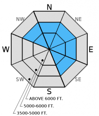
Recent snow with moderate to strong wind created windslabs that remain reactive. The avalanche danger is CONSIDERABLE on wind loaded slopes above 5500 feet. Human triggered avalanches are likely. In other terrain the danger is MODERATE. Human triggered avalanches are possible due to several weak layers that persist in the snowpack. Given the possibility of enhanced precipitation in isolated areas the hazard may rise on non-windloaded slopes. Continue to carefully evaluate the snowpack and choose conservative terrain.

3. Considerable
?
Above 6500 ft.
3. Considerable
?
5000-6500 ft.
2. Moderate
?
3500-5000 ft.
- 1. Low
- 2. Moderate
- 3. Considerable
- 4. High
- 5. Extreme
-
Type ?
-
Aspect/Elevation ?

-
Likelihood ?CertainVery LikelyLikelyPossible
 Unlikely
 -
Size ?HistoricVery LargeLargeSmall

Moderate wind speeds with strong gusts that accompanied the recent snow added more depth to the wind slabs that formed in the past two days. In some areas expect to find fresh windslabs 2-3 feet thick that will remain sensitive to human triggering. These growing wind slabs will continue to stress existing weak layers that may release deeper (step down) in the snowpack and propagate wider making for large avalanches. Look for convex pillows of wind drifted snow on the lee sides of ridges. Carefully evaluate wind loaded terrain before committing to a slope and also be aware of cross-loaded terrain features and gullies at mid elevations.
-
Type ?
-
Aspect/Elevation ?

-
Likelihood ?CertainVery LikelyLikelyPossible
 Unlikely
 -
Size ?HistoricVery LargeLargeSmall

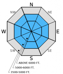
Buried, decomposing surface hoar and weak faceted snow exist in all ranges, but you won't find them on all slopes. Weak snow beneath the January 12 rain crust was the failure layer of the fatal avalanche last Saturday (January 23). The January 17 rain crust continues to be reactive in some stability tests as well. These weak layers are now 2 to 5 feet deep. There is a lot of variability across the advisory area with this avalanche problem that warrants careful snowpack evaluation and cautious route-finding. Over the past few days stability tests in some locations resulted in no fracture or propagation on deeper layers while in other locations these layers show signs of instability. Given the tricky distribution of these persistent slabs it would be wise to avoid steep, open slopes and convexities on all slopes. The only way to know if these layers are reactive is to dig into the snow and perform stability tests. You are more likely to trigger an avalanche on one of these layers in shallow snowpacks where these layers are closer to the snow surface.
-
Type ?
-
Aspect/Elevation ?

-
Likelihood ?CertainVery LikelyLikelyPossible
 Unlikely
 -
Size ?HistoricVery LargeLargeSmall

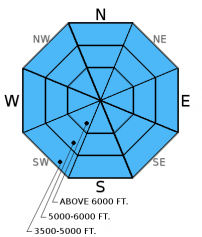
In areas that are not windloaded watch for recent storm snow that settled into a cohesive soft slab and may still be reactive today. These slabs formed on a crust in most locations that will provide a smooth sliding surface. This problem could be compounded in isolated areas where showers organize and bring more snow than expected. In locations where recent snow remains unconsolidated, loose snow avalanches will also be easily triggered in steep terrain. Remember that even small avalanches can have severe consequences if you are caught while traveling in or around terrain traps like narrow gullies, trees, or cliffs.
Though not wide spread across the advisory area, there are locations where large cornices have been observed (and failed). If you encounter large cornices give them a wide buffer as they are likely recently formed and sensitive. Remember that cornices can fail behind the ridgeline and take you with them. Aside from the danger of being hit by a large mass of snow they are the "bombs of the backcountry" and can trigger deep and dangerous avalanches.
The final report for the 1/23/2016 avalanche fatality in Swede Creek in the Whitefish Range is complete and located here: http://www.flatheadavalanche.org/sites/default/files/20160124_swedecreekavalaccidentreport_final.pdf.
Yesterday Mark was in the Skyland area in the Flathead Range. He observed a recent natural avalanche thought to be a wind slab triggered by loose snow (photo). He noted wind drifting the snow on the ridgelines, as well as mid slope level.
BNSF Avalanche Safety reported a large cornice failure in their program area that occured on January 29. The debris slid an estimated 800 vertical feet (photo *observed 1/30).
Skiers in the Swan Range yesterday noted poor bonds in the recent storm snow, active wind drifting, and small, sensitive slabs (observation). Skiers in Cascade Creek in the Flathead Range found 10 inches of new snow that easily slid on steep rollovers. Extended column tests revealed several layers that fractured with moderate to hard force but did not propagate (Observation). Another party of skiers in the Ghoulie Point area in the southern Whitefish Range skied low angle slopes without any obvious signs of instability and also noted active wind drifting snow on ridges and signs of cross-loading in the mid-slopes (observation).
Friday we were on Elk Mountain in southern Glacier Park where a surface crust extended up to about 6300 feet. Winds were light out of the west, but there was evidence of recent wind drifted snow. We found a shallow snowpack and got variable results in stability tests. Recent, thin wind slabs (1 foot thick) fractured and propagated in extended column tests (video). Deeper layers like weak snow near the January 17th crust and January 12 crust fractured but did not propagate.
Thursday, in the Rescue/Skiumah Creek area we found terrible skiing and were able to trigger small, wet loose sluffs on any rollover steeper than 35 degrees. We avoided larger, steep slopes as these wet loose avalanches entrained a fair amount of snow (photo, observation). In stability tests we found mixed results on layers within the top 2 feet and could not get the early January weak snow (below the Jan. 12 rain crust) to fracture in our snow pits. We observed strong winds transporting snow onto leeward slopes.
On Wednesday, Glacier NP rangers were on Apgar Mountain where, in their stability tests, observed fracture and propagation with hard force on the weak snow beneath the Jan. 12 rain crust (observation). Also, on Wednesday at Noisy Basin in the Swan Range, we found mixed results in stability tests illustrating the variability in our snowpack right now. We found very small wind loaded slopes right off the ridge, and observed rollerballs and pinwheels and mid and lower elevations as the day progressed (observation).
On Tuesday, Mark investigated recent avalanche activity from Sunday in the WMR backcountry. He found the storm snow that was responsible for the recent natural and skier triggered avalanches to have settled out (observation). Also on Tuesday, BNSF avalanche safety reported fracture and propagation with moderate force in their stability tests. Failure layer was decomposing surface hoar and facets that were sitting on top of a melt freeze crust formed during the high pressure event of early January. They also reported a collapse in the snowpack at an upper elevation during their tour (video, observation).
For more information on the recent avalanche fatality in Swede Creek, Whitefish Range (1/23/2016) please view the final report here.
Visit our Observations page and our You Tube channel for more observations from the entire season.
Thanks to everyone for submitting observations. They are extremely useful and could help save lives.
HOW TO SUBMIT OBSERVATIONS:
Email: [email protected]
Call and leave a message: 406.387.3821
You can also submit quick observations via text: 406.241.4571 (FAC mobile)
OR
Submit Snowpack Observations: http://www.flatheadavalanche.org/node/add/snowobs
Submit Avalanche Observations: http://www.flatheadavalanche.org/node/add/avyobs
Snow showers yesterday and overnight delivered 1-3 new inches of snow. Light to moderate winds blew out of the west and southwest. Currently, mountain temperatures range from 14º-21º F and winds are southwest 6-16 mph with gusts from 7-22 mph. Today temperatures will rise to the mid 20s. Winds will continue out of the west and southwest at 5-10 mph with gusts to 20 mph. Moderate snow should taper late morning and become snow showers in the afternoon.
| 0600 temperature: | 14-21 deg. F. |
| Max. temperature in the last 24 hours: | 18-27 deg. F. |
| Average wind direction during the last 24 hours: | SW |
| Average wind speed during the last 24 hours: | 5-15 mph |
| Maximum wind gust in the last 24 hours: | 13-40 mph |
| New snowfall in the last 24 hours: | 1-3 inches |
| Total snow depth: | 68-92 inches |
This advisory applies only to backcountry areas outside established ski area boundaries. This advisory describes general avalanche conditions and local variations always occur. This advisory expires at midnight on the posted day unless otherwise noted. The information in this advisory is provided by the USDA Forest Service who is solely responsible for its content.


