| Saturday | Saturday Night | Sunday | |
|---|---|---|---|
| Cloud Cover: | Brief lull in precipitation until snowfall begins this evening. | Snow. | Snow showers continue. |
| Temperatures: | 25-33 deg. F. | 15-23 deg. F. | 23-31 deg. F. |
| Wind Direction: | W-SW | W-SW | W-SW |
| Wind Speed: | 10-15 gusts 23-28 | 7-11 gusts 23 | 5-8 |
| Snowfall: | 0-3 in. | 0-2 in. | 1-5 in. |
| Snow Line: |
Whitefish Range
Swan Range
Flathead Range and Glacier National Park
How to read the forecast
Up to a foot of new snow accompanied by strong, gusty winds added depth to recent wind slabs. The avalanche danger is HIGH on wind loaded slopes above 6000 feet and CONSIDERABLE in all other terrain. New storm and wind slabs will add stress to a variety of weak layers that persist in the snowpack. Avoid avalanche terrain at upper elevations including run out zones. Careful snowpack evaluation, cautious route-finding, and conservative decision making are essential.

4. High
?
Above 6500 ft.
3. Considerable
?
5000-6500 ft.
3. Considerable
?
3500-5000 ft.
- 1. Low
- 2. Moderate
- 3. Considerable
- 4. High
- 5. Extreme
-
Type ?
-
Aspect/Elevation ?

-
Likelihood ?CertainVery LikelyLikelyPossible
 Unlikely
 -
Size ?HistoricVery LargeLargeSmall

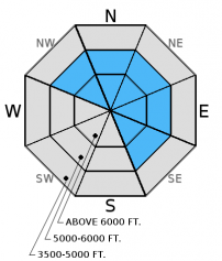
Moderate wind speeds with strong gusts that accompanied the snow in the past 24 hours added more depth to the wind slabs that formed in the past two days. In some areas expect to find fresh windslabs 2-3 feet thick that will be sensitive to human triggering. We were surprised by the light wind on Elk Mountain yesterday, but local weather stations told a different story with sustained wind speeds of 20-25 mph recorded in other areas in the Flathead Range and northern Whitefish Range. These wind slabs will continue to stress existing weak layers that may release deeper (step down) in the snowpack and propagate wider making for large avalanches. Look for convex pillows of wind drifted snow on the lee sides of ridges. Avoid wind loaded terrain and run-out zones and also be aware of cross-loaded slopes and gullies as well.
-
Type ?
-
Aspect/Elevation ?

-
Likelihood ?CertainVery LikelyLikelyPossible
 Unlikely
 -
Size ?HistoricVery LargeLargeSmall

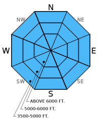
In the past 24 hours we got up to a foot of new snow (0.5-1.0 inch of snow water equivalent). New storm slabs formed on a crust in most locations that will provide a smooth sliding surface. In areas where a new slab did not form loose snow avalanches will also be easily triggered in steep terrain. Remember that even small avalanches can have severe consequences if you are caught while traveling in or around terrain traps like narrow gullies, trees, or cliffs.
-
Type ?
-
Aspect/Elevation ?

-
Likelihood ?CertainVery LikelyLikelyPossible
 Unlikely
 -
Size ?HistoricVery LargeLargeSmall

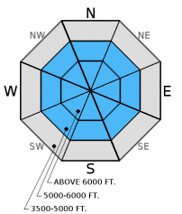
Rain and heavy snow over the past few days was a decent test to our existing weak layers. Buried surface hoar and weak faceted snow exist in all ranges, but you won't find them on all slopes. Weak snow beneath the January 12 rain crust was the failure layer of the fatal avalanche last Saturday. The January 17 rain crust continues to be reactive in some stability tests as well. These weak layers are now 2 to 5 feet deep. There is a lot of variability across the advisory area with this avalanche problem that warrants careful snowpack evaluation and cautious route-finding. Over the past few days stability tests in some locations resulted in no fracture or propagation on deeper layers while in other locations these layers show signs of instability. Given the tricky distribution of these persistent slabs it would be wise to avoid steep, open slopes and convexities on all slopes. The only way to know if these layers are reactive is to dig into the snow and perform stability tests. You are more likely to trigger an avalanche on one of these layers in shallow snowpacks where these layers are closer to the snow surface.
The final report for the 1/23/2016 avalanche fatality in Swede Creek in the Whitefish Range is complete and located here: http://www.flatheadavalanche.org/sites/default/files/20160124_swedecreekavalaccidentreport_final.pdf.
Yesterday we were on Elk Mountain in southern Glacier Park where a surface crust extended up to about 6300 feet. Winds were light out of the west, but there was evidence of recent wind drifted snow. We found a shallow snowpack and got variable results in stability tests. Recent, thin wind slabs (1 foot thick) fractured and propagated in extended column tests (video). Deeper layers like weak snow near the January 17th crust and January 12 crust fractured but did not propagate.
Thursday, in the Rescue/Skiumah Creek area we found terrible skiing and were able to trigger small, wet loose sluffs on any rollover steeper than 35 degrees. We avoided larger, steep slopes as these wet loose avalanches entrained a fair amount of snow (photo, observation). In stability tests we found mixed results on layers within the top 2 feet and could not get the early January weak snow (below the Jan. 12 rain crust) to fracture in our snow pits. We observed strong winds transporting snow onto leeward slopes.
On Wednesday, Glacier NP rangers were on Apgar Mountain where, in their stability tests, observed fracture and propagation with hard force on the weak snow beneath the Jan. 12 rain crust (observation). Also, on Wednesday at Noisy Basin in the Swan Range, I found mixed results in stability tests ilustrating the variability in our snowpack right now. We found very small wind loaded slopes right off the ridge, and observed rollerballs and pinwheels and mid and lower elevations as the day progressed (observation).
On Tuesday, Mark investigated recent avalanche activity from Sunday in the WMR backcountry. He found the storm snow that was responsible for the recent natural and skier triggered avalanches to have settled out (observation). Also on Tuesday, BNSF avalanche safety reported fracture and propagation with moderate force in their stability tests. Failure layer was decomposing surface hoar and facets that were sitting on top of a melt freeze crust formed during the high pressure event of early January. They also reported a collapse in the snowpack at an upper elevation during their tour (video, observation).
For more information on the recent avalanche fatality in Swede Creek, Whitefish Range (1/23/2016) please view the final report here.
Visit our Observations page and our You Tube channel for more observations from the entire season.
Thanks to everyone for submitting observations. They are extremely useful and could help save lives.
HOW TO SUBMIT OBSERVATIONS:
Email: [email protected]
Call and leave a message: 406.387.3821
You can also submit quick observations via text: 406.241.4571 (FAC mobile)
OR
Submit Snowpack Observations: http://www.flatheadavalanche.org/node/add/snowobs
Submit Avalanche Observations: http://www.flatheadavalanche.org/node/add/avyobs
In the past 24 hours temperatures fell and we got another shot of snow. We picked up 3 to 9 inches across the advisory area. Winds were out of the southwest at 10-20 mph with gusts from 21-41 mph. Currently, temperatures above 6000 feet range from 18º-25º F and winds are 5-24 mph with gusts from 10-32 mph out of the west and southwest. Today we could see a few lingering snow showers increasing this evening. Temperatures are expected to rise to the upper 20s. Winds will continue to move out of the west and southwest at 10-15 mph gusting to 25 mph.
| 0600 temperature: | 18-25 deg. F. |
| Max. temperature in the last 24 hours: | 22-30 deg. F. |
| Average wind direction during the last 24 hours: | WSW |
| Average wind speed during the last 24 hours: | 10-20 mph |
| Maximum wind gust in the last 24 hours: | 21-41 mph |
| New snowfall in the last 24 hours: | 3-9 inches |
| Total snow depth: | 67-93 inches |
This advisory applies only to backcountry areas outside established ski area boundaries. This advisory describes general avalanche conditions and local variations always occur. This advisory expires at midnight on the posted day unless otherwise noted. The information in this advisory is provided by the USDA Forest Service who is solely responsible for its content.


