| Thursday | Thursday Night | Friday | |
|---|---|---|---|
| Cloud Cover: | Rain and Snow. Snow level around 5000-6000 feet. | Continued rain and snow. | Snow levels lowering to 3000 feet and snow tapering by morning. |
| Temperatures: | 34 to 45 deg. F. | 26 to 31 deg. F. | 28 to 38 deg. F. |
| Wind Direction: | Southwest | Southwest | Southwest |
| Wind Speed: | 17-21 mph with gusts to 48 mph. | 23 to 30 mph with gusts to 55 mph. | 10-15 mph with gusts to 25 mph. |
| Snowfall: | 0-3 in. | 1-4 in. | 0-1 in. |
| Snow Line: |
Whitefish Range
Swan Range
Flathead Range and Glacier National Park
How to read the forecast
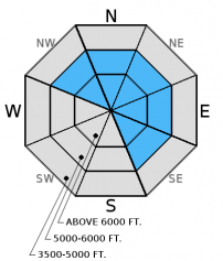
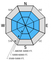
The avalanche danger will rise to CONSIDERABLE on all slopes today and could reach HIGH by tonight. New snow, rain on snow, and strong winds will create dangerous avalanche conditions that include wet and dry snow avalanches. Human triggered avalanches will become more likely and natural avalanches are possible. New snow/rain combined with weak snow surrounding a variety of crusts deeper in the snowpack makes it dangerous and tricky right now. Pay attention to rapidly changing conditions. See discussion below.

3. Considerable
?
Above 6500 ft.
3. Considerable
?
5000-6500 ft.
3. Considerable
?
3500-5000 ft.
- 1. Low
- 2. Moderate
- 3. Considerable
- 4. High
- 5. Extreme
-
Type ?
-
Aspect/Elevation ?

-
Likelihood ?CertainVery LikelyLikelyPossible
 Unlikely
 -
Size ?HistoricVery LargeLargeSmall

Wind speeds will increase today with average speeds of 20-30 mph and gusts to 70 mph. Such strong to extreme winds will easily transport new snow creating fresh wind slabs at mid- to upper elevations today. These wind slabs will continue to stress existing weak layers that may release deeper (step down) in the snowpack and propagate wider. Look for smooth, rounded features on the snow surface or deeper looking pillows. Carefully evaluate all wind loaded terrain and be aware of cross-loaded slopes as well.
Storm slabs could also become a problem by tonight as wet, heavy snow falls at upper elevations. Storm slabs will exist on all aspects and could fail at the new and old snow interface or within the new storm snow. These slabs could also step down to deeper instabilities in the snowpack.
-
Type ?
-
Aspect/Elevation ?

-
Likelihood ?CertainVery LikelyLikelyPossible
 Unlikely
 -
Size ?HistoricVery LargeLargeSmall

Today's rain on snow and new snow will continue to add weight to our existing snowpack. Buried surface hoar and weak faceted snow exist in all ranges, but you won't find them on all slopes and they vary in reactivity. Weak snow beneath the January 12 rain crust was the failure layer of the fatal avalanche on Saturday. The January 17 rain crust continues to be reactive in some stability tests as well. These weak layers are now 2 to 5 feet deep. There is a lot of variability across the advisory area with this persistent slab problem that warrants careful snowpack evaluation and cautious route-finding. Over the past couple of days stability tests in some locations resulted in no fracture or propagation on deeper layers while in other locations (like southern Glacier NP) BNSF Avalanche Safety were able to produce fracture and propagation in their stability tests on Tuesday. Given the tricky distribution of these persistent slabs it would be wise to avoid steep, open slopes and convexities on all slopes. The only way to know if these layers are reactive is to dig into the snow and perform stability tests.
-
Type ?
-
Aspect/Elevation ?

-
Likelihood ?CertainVery LikelyLikelyPossible
 Unlikely
 -
Size ?HistoricVery LargeLargeSmall

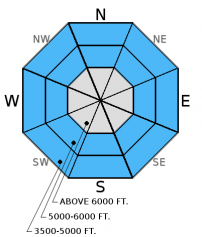
Wet loose avalanches will become more likely as the day progresses. Rain on snow at lower, mid-, and potentially even upper elevations will cause the surface snow to weaken and avalanche. Expect both natural and human triggered wet, loose avalanches. Signs of wet snow instability include moist surface snow and rollerballs/pinwheels (image). If you begin to see signs of wet loose activity, then it's time to move to less steep slopes. These avalanches, while typically slow moving and sometimes small, can pack a punch especially in terrain traps like gullies.
Wet Slab: A layer of graupel exists around a foot from the surface in many locations. This layer produced fracture in many stability tests over the past couple of days, but not propagation. However, with rain on snow today, this layer could become reactive and we could see rain initiated wet slab avalanches.
There is a fair amount of uncertainty associated with the danger level today due to the timing of the incoming storm system as well as exact precipitation amounts. Yesterday, the danger was Considerable on wind loaded slopes and Moderate elsewhere (where it was still possible to trigger an avalanche on deeper weak layers). Today, that will change. It appears that precipitation will increase throughout the day with the potential for up to one inch of liquid by tonight, particularly in the Swan Range, Flathead Range, and Glacier National Park. This translates to heavy, wet snow at upper elevations and rain at mid- to low elevations. Given the deeper weak layers in our snowpack we could see the avalanche danger rise to HIGH before temperatures cool. Pay attention to these changing conditions. Rain on snow adds weight to the snowpack very quickly, and conditions could become very dangerous.
The final report for the 1/23/2016 avalanche fatality in Swede Creek in the Whitefish Range is complete and located here: http://www.flatheadavalanche.org/sites/default/files/20160124_swedecreekavalaccidentreport_final.pdf.
For more information on the recent avalanche fatality (1/23/2016) please visit our observations page (observation).
Yesterday, at Noisy Basin in the Swan Range, I found mixed results in stability tests ilustrating the variability in our snowpack right now. We found very small wind loaded slopes right off the ridge, and observed rollerballs and pinwheels and mid and lower elevations as the day progressed (observation). Skiers in Canyon Creek in the southern Whitefish Range noted previous wind loading, but no obvious signs of instability in their travels yesterday.
On Tuesday, Mark investigated recent avalanche activity in the WMR backcountry. We found the storm snow that was responsible for the recent natural and skier triggered avalanches to have settled out and was not reactive in stability tests or with ski cutting. Our snowpit revealed the January 12 rain crust but stability tests showed no results on this layer (photo, photo, observation).
Also on Tuesday, BNSF avalanche safety reported fracture and propagation with moderate force in their stability tests. Failure layer was decomposing surface hoar and facets that were sitting on top of a melt freeze crust formed during the high pressure event of early January. This crust was only 20 inches from the snow surface which confirms the limited snowfall that has occurred in John F. Stevens Canyon in January. They also reported a collapse in the snowpack at an upper elevation during their tour (video, observation).
Sunday, experienced skiers in the southern Whitefish Range reported a natural avalanche on a northerly aspect in Canyon Creek at an upper elevation. They also reported remotely triggering the Half Moon slide path, east of the ski area, from 80-100 feet above the starting zone. The same party noted mid elevation natural avalanche activity in this same area. The failure layer appears to have been the storm slab deposited Saturday night/Sunday morning. Crown depths were reported to be in the 8-10 inch range.
Visit our Observations page and our You Tube channel for more observations from the entire season.
Thanks to everyone for submitting observations. They are extremely useful and could help save lives.
HOW TO SUBMIT OBSERVATIONS:
Email: [email protected]
Call and leave a message: 406.387.3821
You can also submit quick observations via text: 406.241.4571 (FAC mobile)
OR
Submit Snowpack Observations: http://www.flatheadavalanche.org/node/add/snowobs
Submit Avalanche Observations: http://www.flatheadavalanche.org/node/add/avyobs
In the past 24 hours, 1-2 inches of new snow fell above 6000 feet across the advisory area with moderate to strong winds (5-27 mph with gusts to 40 mph). A warm, wet storm will enter the region today bringing a mixed bag of rain and snow and increasing wind speeds. Currently, temperatures above 6000 feet range from a balmy 30º-35º F and winds are moving out of the southwest at 11-27 mph with gusts to 40 mph. For today, expect precipitation to increase this morning and last throughout the day with potentially up to an inch of liquid water eqivalent and 7-8 inches of snow by tonight in the Swan Range, Flathead Range, and Glacier National Park. Temperatures should be in the low to mid 30s at upper elevations and low 40s F at lower elevations. Winds will be out of the southwest at 15-30 mph with gusts to 70 mph.
| 0600 temperature: | 30 to 35 deg. F. |
| Max. temperature in the last 24 hours: | 32 to 35 deg. F. |
| Average wind direction during the last 24 hours: | Southwest |
| Average wind speed during the last 24 hours: | 5-27 mph |
| Maximum wind gust in the last 24 hours: | 19-40 mph |
| New snowfall in the last 24 hours: | 1-2 inches |
| Total snow depth: | 59-81 inches |
This advisory applies only to backcountry areas outside established ski area boundaries. This advisory describes general avalanche conditions and local variations always occur. This advisory expires at midnight on the posted day unless otherwise noted. The information in this advisory is provided by the USDA Forest Service who is solely responsible for its content.


