| Friday | Friday Night | Saturday | |
|---|---|---|---|
| Cloud Cover: | Light snow and moderate to strong winds. | Light snow and moderate to strong winds. | Transition day before another storm rolls in later in the day. |
| Temperatures: | 22 to 30 deg. F. | 13 to 20 deg. F. | 22 to 30 deg. F. |
| Wind Direction: | Southwest | Southwest | Southwest |
| Wind Speed: | 5-10 mph with gusts to 25 mph. | 5-10 mph with gusts to 25 mph. | 4-5 mph. |
| Snowfall: | 2-6 in. | 1-5 in. | 1-3 in. |
| Snow Line: |
Swan Range
How to read the forecast
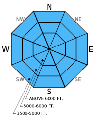
The avalanche danger is HIGH above 6000 feet and CONSIDERABLE below. Dangerous avalanche conditions exist. The Swan Range received over 30 inches of snow and 5.2 inches of SWE in the past 48 hours. This is a huge load for any snowpack. Even though snowfall has tapered for the last 12 hours, both natural and human triggered avalanches are likely. Travel in avalanche terrain is not recommended. Stay off of and out from underneath slopes steeper than 30 degrees.

4. High
?
Above 6500 ft.
3. Considerable
?
5000-6500 ft.
3. Considerable
?
3500-5000 ft.
- 1. Low
- 2. Moderate
- 3. Considerable
- 4. High
- 5. Extreme
-
Type ?
-
Aspect/Elevation ?

-
Likelihood ?CertainVery LikelyLikelyPossible
 Unlikely
 -
Size ?HistoricVery LargeLargeSmall

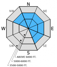
Even though snowfall has tapered dangerous avalanche conditions still exist. Storm and wind slab avalanches were observed yesterday and I expect them to still be easily triggered today. Surface hoar from early January and near surface facets exist throughout the advisory area though the distribution is somewhat spotty. These weak layers are now 1.5 to 4 feet deep after this storm. On Wednesday, many parts of our advisory area received freezing rain from valley floors to upper elevations. This crust was the bed surface of a skier triggered storm slab yesterday in the southern Whitefish Range, and surface hoar was the failure layer for natural and human triggered wind slabs in southern Glacier Park yesterday. Surface hoar is notorious for propagating long distances across and up a slope. Avalanches can be triggered from flat runout zones below slopes so avoid being underneath slopes today. Look for obvious signs of instability like recent avalanche activity, shooting cracks, and whumpfing.
-
Type ?
-
Aspect/Elevation ?

-
Likelihood ?CertainVery LikelyLikelyPossible
 Unlikely
 -
Size ?HistoricVery LargeLargeSmall

Fresh wind slabs formed on top of a variety of surfaces including sun crusts, freezing rain crusts and buried surface hoar. BNSF Avalanche Safety intentionally triggered a wind slab yesterday on a test slope and observed recent natural wind slabs on northerly aspects. Wind slabs are likely to be thicker in the precipitation favored Swan Range and in areas near the Continental Divide where wind speeds have been stronger. Look for smooth, rounded features on the slope especially on steep convex rollovers, on leeward sides of ridges and cross-loaded gullies. Wind slabs could be over 4 feet thick making them very dangerous.
Tricky conditions with buried surface hoar. Surface hoar has been observed in all ranges throughout the advisory area, but not on all slopes. This makes it tricky. Some slopes (or even parts of one slope) may avalanche on this layer and others may not. The nature and distribution of this weak layer requires cautious route-finding and conservative decision making.
Deeper layers in the snowpack like the December 9 rain crust and weak snow near the ground in areas with a shallow snowpack are unlikely to be awakened during this storm, but it's not impossible. As you dig deep into the snowpack you will encounter the remnants of the December 9 rain crust. This crust/ice mass is a good landmark to monitor as the season progresses.
An avalanche accident occurred in the St. Regis Basin area Wednesday along the Idaho/Montana border near Lookout Pass. This area is within the Idaho Panhandle National Forest Avalanche Center advisory area. Injuries were sustained, but there were no fatalities. Our thoughts go to all involved for a swift recovery.
Yesterday, we easily triggered a storm slab (12-16 inches deep and 50 feet wide) from the top of a flat, safe ridge just east and outside the boundary of Whitefish Mountain Resort (video, photo). The slab failed on the freezing rain crust that formed Wednesday (1/12/2016).
Also, yesterday in John F. Stevens Canyon in southern Glacier NP, BNSF Avalanche Safety observed 3 natural wind slab avalanches and intentionally triggered another on a test slope (photo, observation). The deepest part of the slab was 50 inches deep and failed on buried surface hoar.
Skiers in the Swan Range yesterday stated they stuck to low angled slopes in tight trees, but experienced collapsing (whumpfing) of the snowpack numerous times. They also observed shooting cracks and sensitive storm slabs on small, steeper rollovers (observation).
In the Marion Lake/Dickey Creek area of the Flathead Range Wednesday I observed active wind loading and a developing wind slab on near surface weak layers (observation, video). Wednesday, skiers in the southern Whitefish Range found buried surface hoar about 4-5 inches below the surface, and noted localized shooting cracks on this layer (observation). Skiers in the Skyland area yesterday found buried facets a few inches below the surface and recent wind slab activity on Slippery Bill Mountain (observation).
On Tuesday, a party of skiers in the Middle Fork reported triggering 2 thin wind slabs (photo). They also reported a freezing rain crust that extended from the valley floor to the upper elevations (observation). Also on Tuesday, GNP rangers outside the advisory area in Boundary Creek in northern Glacier Park found very reactive buried surface hoar in their stability tests and observed sensitive wind slabs on convex rollovers (observation).
Thanks to everyone for submitting observations. They are extremely useful for everyone.
Visit our Observations page and our You Tube channel for more observations from the entire season.
Please let us know what you are seeing out there. Your observations are important and valued.
HOW TO SUBMIT OBSERVATIONS:
Email: [email protected]
Call and leave a message: 406.387.3821
You can also submit quick observations via text: 406.241.4571 (FAC mobile)
OR
Submit Snowpack Observations: http://www.flatheadavalanche.org/node/add/snowobs
Submit Avalanche Observations: http://www.flatheadavalanche.org/node/add/avyobs
A very wet storm system pounded the advisory area Wednesday night through yesterday. The Swan Range (represented by Noisy Basin SNOTEL) received a storm total of over 30 inches of snow and 5.2 inches of snow water equivalent (SWE) over the past 48 hours! The bulk of this precipitation fell Wednesday night until 4:00 pm yesterday when the faucet finally turned to a relative drip. The rest of the advisory area received 8 to 20 inches of snow with the storm (0.4 to 2.2 inches of SWE) and winds were moderate to strong out of the southwest.
Currently, mountain weather stations report temperatures ranging from 16 - 22º F at upper elevations with winds out of the southwest at 2-5 mph and gusts up to 11 mph. Today, expect light snow with another 1-5 inches of accumulation across the advisory area and winds moving out of the southwest at 5-10 mph with gusts to 25 mph.
| 0600 temperature: | 16 to 22 deg. F. |
| Max. temperature in the last 24 hours: | 24 to 29 deg. F. |
| Average wind direction during the last 24 hours: | Southwest |
| Average wind speed during the last 24 hours: | 6-12 mph |
| Maximum wind gust in the last 24 hours: | 12-21 mph |
| New snowfall in the last 24 hours: | 4-30 inches |
| Total snow depth: | 52-76 inches |
This advisory applies only to backcountry areas outside established ski area boundaries. This advisory describes general avalanche conditions and local variations always occur. This advisory expires at midnight on the posted day unless otherwise noted. The information in this advisory is provided by the USDA Forest Service who is solely responsible for its content.


