| Wednesday | Wednesday Night | Thursday | |
|---|---|---|---|
| Cloud Cover: | Snow/rain | Snow with lowering snow levels. Swan Range favored | Continued snow with the Swan Range favored |
| Temperatures: | 29-38 deg. F. | 21-26 deg. F. | 26-33 deg. F. |
| Wind Direction: | SW | SW | SW |
| Wind Speed: | 13-20 gusts 44 | 9-16 gusts 37 | 9-14 gusts 29 |
| Snowfall: | 2-6 in. | 3-9 in. | 2-13 in. |
| Snow Line: |
Whitefish Range
Swan Range
Flathead Range and Glacier National Park
How to read the forecast
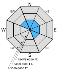
Today, the avalanche danger will begin as MODERATE but may rise to CONSIDERABLE by the end of the day above 6000 feet, especially on wind loaded terrain steeper than 35º. Today's snowfall and moderate winds will form slabs on top of crusts and near surface weak layers. Human triggered avalanches are likely with natural avalanches possible. Carefully evaluate the snowpack before committing to any slope, particularly in steep, wind loaded terrain. The avalanche danger is MODERATE on all other terrain.

3. Considerable
?
Above 6500 ft.
2. Moderate
?
5000-6500 ft.
2. Moderate
?
3500-5000 ft.
- 1. Low
- 2. Moderate
- 3. Considerable
- 4. High
- 5. Extreme
-
Type ?
-
Aspect/Elevation ?

-
Likelihood ?CertainVery LikelyLikelyPossible
 Unlikely
 -
Size ?HistoricVery LargeLargeSmall

Warm moist snowfall, coupled with moderate winds and strong gusts, will form fresh wind slabs on top of a variety of surfaces including sun crusts, freezing rain crusts and buried near surface weak layers. As the day progresses human triggered avalanches will be likely and natural avalanches will be possible. It remains important to carefully assess windloaded areas before committing to a slope. Wind slabs are likely to be thicker in areas near the Continental Divide where wind speeds have been stronger and in the Swan Range which looks to be the favored location for snowfall with this storm. Look for smooth, rounded features on the slope especially on steep convex rollovers, on leeward sides of ridges and cross-loaded gullies.
-
Type ?
-
Aspect/Elevation ?

-
Likelihood ?CertainVery LikelyLikelyPossible
 Unlikely
 -
Size ?HistoricVery LargeLargeSmall

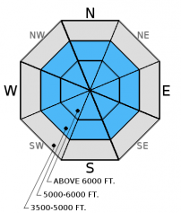
By this afternoon storm slabs should form in areas favored by today's storm such as the Swan Range. These slabs will be deposited on top of a variety of crusts and near surface weak layers. Human triggered avalanches will be possible.
-
Type ?
-
Aspect/Elevation ?

-
Likelihood ?CertainVery LikelyLikelyPossible
 Unlikely
 -
Size ?HistoricVery LargeLargeSmall

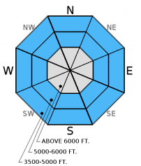
With rising snow levels forecast rain may fall at low and mid elevations. Rain adds weight to the snowpack but does not add strength. The first sign of surface instablity with be rollerball activity. Although the size of these slides will be small the consequences will be compounded if these slides push you into trees, rocks, over a cliff or into a terrain trap.
New storm snow depositing on near surface weak layers, slippery sun crusts and freezing rain crusts. With a storm system entering our area today, we need to be aware that new snow may be falling on weak layers and/or crusts that were formed recently. Surface hoar and near surface facets (small, weak snow grains just under the snow surface) exist throughout the advisory area. Recent snowfall buried these weak layers, but they should not become an "out of sight, out of mind" issue. It is important to monitor the reactivity of these weak layers as new storm snow continues to accumulate on top of them. On sunny aspects, a sun crust formed that could become a potential bed surface as more snow falls as well. Yesterday, parts of our advisory area received freezing rain from valley floors to upper elevations. This crust will also serve as a potential bed surface.
As you dig deep into the snowpack you will encounter the remnants of the December 9 rain crust. Currently it is located about 2/3 below the snow surface. This crust/ice mass is a good landmark to monitor as the season progresses.
On Tuesday, a party of skiers in the Middle Fork reported triggering 2 thin wind slabs (photo). They also reported a freezing rain crust that extended from the valley floor to the upper elevations (observation).
Sunday, skiers in the Middle Fork noted "lots of wind" that was transporting snow in the upper elevations but they noted that this newly drifted snow was not reactive.
On Saturday, Guy and I traveled to Baldhead Mountain in the Flathead Range. We found soft, cohesionless wind drifted snow on leeward aspects and buried surface hoar 2-4 inches deep (photo). We also noted weak snow near the ground that was unreactive in stability tests (observation).
Also on Saturday, skiers in the Marion Lake area, also in the Flathead Range found a shallow snowpack (about 3 feet deep). On sunny aspects they found a 1 inch crust with 2 inches of recent snow on top. Below the crust they noted weak snow that failed and propagated in stability tests.
Friday, Erich and Todd traveled up a ridge that divides the Lost Johnny and Wounded Buck drainages in the Swan Range. They observed buried surface hoar and near surface facets in the top 2-3 inches of snow. The snowpack in this area was deep and uniform (photo, video).
Thursday, Erich went on the hunt in the southern Whitefish Range for recently buried surface hoar, and was successful. He found it about 2 inches below the surface. See observation and video for details. Skiers in the Paola Creek drainage in the Flathead Range noted wind transport near ridgetops and developing wind slabs in exposed areas (observation).
Thanks to everyone for submitting observations. They are extremely useful for everyone.
Visit our Observations page and our You Tube channel for more observations from the entire season.
Please let us know what you are seeing out there. Your observations are important and valued.
HOW TO SUBMIT OBSERVATIONS:
Email: [email protected]
Call and leave a message: 406.387.3821
You can also submit quick observations via text: 406.241.4571 (FAC mobile)
OR
Submit Snowpack Observations: http://www.flatheadavalanche.org/node/add/snowobs
Submit Avalanche Observations: http://www.flatheadavalanche.org/node/add/avyobs
A warm moist air mass moved into our area overnight. Currently, we have light snow showers, mountain temperatures have warmed and range from 27 - 33º F at upper elevations and winds are out of the southwest at 7-15 mph with gusts up to 18 mph. Today, expect snow to continue through the day with the snow level rising and moderate winds with strong gusts continuing out of the southwest. A second wave of precipitation will move through our area tonight through tomorrow with freezing levels lowering and possible substantial snowfall for the Swan Range.
| 0600 temperature: | 27-33 deg. F. |
| Max. temperature in the last 24 hours: | 27-33 deg. F. |
| Average wind direction during the last 24 hours: | SW |
| Average wind speed during the last 24 hours: | 5-15 mph |
| Maximum wind gust in the last 24 hours: | 30 mph |
| New snowfall in the last 24 hours: | 0 inches |
| Total snow depth: | 45-60 inches |
This advisory applies only to backcountry areas outside established ski area boundaries. This advisory describes general avalanche conditions and local variations always occur. This advisory expires at midnight on the posted day unless otherwise noted. The information in this advisory is provided by the USDA Forest Service who is solely responsible for its content.


