| Friday | Friday Night | Saturday | |
|---|---|---|---|
| Cloud Cover: | Light snow showers. | Snow showers ending.. | High pressure building |
| Temperatures: | 14-22 deg. F. | -4-10 deg. F. | 16-25 deg. F. |
| Wind Direction: | E-N | SE-W | SW |
| Wind Speed: | 4-5 gusts 17 | 3 | 5-8 gusts 21 |
| Snowfall: | 0-1 in. | 0-1 in. | 0 in. |
| Snow Line: |
Swan Range
How to read the forecast
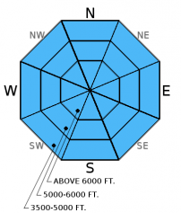
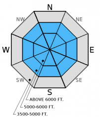
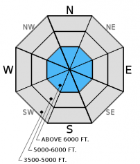
Over the past 4 days the Swan Range received 4.8 inches of snow water equivalent. The avalanche danger above 6000 feet is HIGH. Travel in avalanche terrain is NOT recommended and both natural and human triggered avalanches are likely. Below 6000 feet the danger is CONSIDERABLE. Advisory for other ranges here.

4. High
?
Above 6500 ft.
3. Considerable
?
5000-6500 ft.
3. Considerable
?
3500-5000 ft.
- 1. Low
- 2. Moderate
- 3. Considerable
- 4. High
- 5. Extreme
-
Type ?
-
Aspect/Elevation ?

-
Likelihood ?CertainVery LikelyLikelyPossible
 Unlikely
 -
Size ?HistoricVery LargeLargeSmall

With continued new snow at all elevations we still maintain a storm slab concern throughout our advisory area. On steeper convex rollovers soft slabs were easily triggered in the past few days, and these slabs will still be sensitive on steep slopes today. We observed small natural storm slabs on steep slopes at low elevation on Wednesday. Because this is a surface snow problem it is easy to identify. Dig into the new snow and see how this layer is bonding to the recent snow from this weekend. This new snow needs time to stabilize so cautious route finding and conservative decision making are essential again today.
-
Type ?
-
Aspect/Elevation ?

-
Likelihood ?CertainVery LikelyLikelyPossible
 Unlikely
 -
Size ?HistoricVery LargeLargeSmall

Wind speeds throughout our recent storm cycle have been relatively low. However, with abundant low density surface snow available for transport, even a light breeze can quickly transport snow, load leeward slopes and create soft slabs. Winds have shifted to a north through easterly direction in parts of our advisory area so be aware of atypical loading patterns. Keep in mind that recent wind slabs may be more difficult to identify with new snow on top. Look for obvious signs of instability like cracking and collapsing in denser pockets of snow. Continue to carefully evaluate wind-loaded areas before skiing or riding the slope.
-
Type ?
-
Aspect/Elevation ?

-
Likelihood ?CertainVery LikelyLikelyPossible
 Unlikely
 -
Size ?HistoricVery LargeLargeSmall

The primary persistent slab concern continues to be the weak, faceted snow above and below the Dec. 9 crust. This layer is generally found now 2.5 to 3.5 feet from the surface and exists in most locations across the advisory area. So far, we have not seen avalanche activity associated with this weak snow. The recent bountiful storms have put this layer to a substantial test. We will reevaluate this problem layer in the coming days. Continue to dig into the snow and assess this layer before committing to a slope.
With the recent abundant snow fall pay attention to loose snow avalanches in steep terrain. They are easy to manage but can pack a punch if they catch you off guard, especially while traveling in and around terrain traps.
In some locations in the Flathead Range, Glacier Park, and parts of the Swan Range we noted and have received observations of weak, sugary snow near the ground. In some places it breaks and propagates across a column in stability tests, and sometimes it doesn't even break. With the December 9 rain crust fairly thick in places, it makes affecting these deeper layers more difficult. Though it appears very isolated in distribution, it is worth mentioning that skiers in the southern Whitefish Range found buried surface hoar Sunday which further illustrates the importance of digging in the snow to see what is going on below you.
Yesterday, experienced snowmobilers in the Lost Johnny area observed shooting cracks, which is an obvious sign of instability, in the recent storm snow. They reported a DEEP (3-5 feet) snowpack at lower elevations. This same party were also able to hear a large avalanche in the distance.
Whitefish Mountain Resort ski patrol reported triggering soft slab avalanches with explosives yesterday. The failure layer was the new snow/old snow interface. This layer varied between the 2 waves of precipitation received over the previous 2 days. The soft slabs did not propagate wide but, due to the low density surface/near surface snow, were able to run long distances (almost full path).
On Wednesday Erich traveled to the Ghoulie Point area in the southern Whitefish Range and found cohesionless surface snow near the ridgeline. At low elevation (below 5000 feet) he noted recent natural avalanche activity in the form of very thin soft slabs (4-5 inches thick) that failed and propagated fairly wide on steep cutbanks due to storm snow that was slightly heavier.
Also on Wednesday a seperate party in the Ghoulie Point area also noted cohesionless surface that did not react in stability tests (observation).
Tuesday, Erich was in the Marion Lake area in the Flathead Range (observation 1 and video) They stuck to slopes much less than 35 degrees. There was about 14-16 inches of light, new snow that on small convex rollovers formed soft slab avalanches (observation 2 and photo). They did not propagate very wide, but the slopes were relatively small. The debris entrained enough snow to knock a person over and potentially bury them.
Visit our Observations page and our You Tube channel for more information from the entire season.
Please let us know what you are seeing out there. Your observations are important and valued.
HOW TO SUBMIT OBSERVATIONS:
Email: [email protected]
Call and leave a message: 406.387.3821
You can also submit quick observations via text: 406.241.4571 (FAC mobile)
OR
Submit Snowpack Observations: http://www.flatheadavalanche.org/node/add/snowobs
Submit Avalanche Observations: http://www.flatheadavalanche.org/node/add/avyobs
The impressive recent storm cycle is slowly winding down. It has left behind substantial snow fall and water (snow water equivalent). In the past 24 hours we picked up an additional 2-14 inches of new snow. Many automated stations are underreporting new snow due to settlement in the low density storm snow. Whitefish Mountain Resort is reporting 14 inches of new snow with Noisy Basin in the Swan Range picking up an additional 1 inch of snow water equivalent. Temperatures at all elevations have cooled due to colder air infiltrating our area from east of the Continental Divide. Currently, mountain temperatures range from 0º-20º F with winds out of the north-east at 2-7 mph. Today, expect light snow showers to taper off with temperatures reaching the low to upper teens and winds moving 5-10 mph out of the north-east with gust ups to 17.
| 0600 temperature: | 0-20 deg. F. |
| Max. temperature in the last 24 hours: | 17-23 deg. F. |
| Average wind direction during the last 24 hours: | SW |
| Average wind speed during the last 24 hours: | 3-9 mph |
| Maximum wind gust in the last 24 hours: | 5-19 mph |
| New snowfall in the last 24 hours: | 2-14 inches |
| Total snow depth: | 65-76 inches |
This advisory applies only to backcountry areas outside established ski area boundaries. This advisory describes general avalanche conditions and local variations always occur. This advisory expires at midnight on the posted day unless otherwise noted. The information in this advisory is provided by the USDA Forest Service who is solely responsible for its content.


