THIS AVALANCHE FORECAST EXPIRED ON December 22, 2015 @ 12:04 am
Avalanche Forecast published on December 21, 2015 @ 7:04 am
Issued by Todd Hannan - Flathead National Forest

Whitefish Range
Swan Range
Flathead Range and Glacier National Park

How to read the forecast

Winds increased yesterday and continued overnight adding depth to recently formed wind slabs. Above 6000 feet the avalanche danger is CONSIDERABLE on wind loaded slopes and MODERATE elsewhere. Human triggered avalanches are likely in wind loaded terrain. Carefully evaluate each slope for reactive wind slabs before skiing or riding on it.


3. Considerable

?

Above 6500 ft.
Dangerous avalanche conditions. Careful snowpack evaluation, cautious route-finding and conservative decision-making essential.

2. Moderate

?

5000-6500 ft.
Heightened avalanche conditions on specific terrain features. Evaluate snow and terrain carefully; identify features of concern.

2. Moderate

?

3500-5000 ft.
Heightened avalanche conditions on specific terrain features. Evaluate snow and terrain carefully; identify features of concern.
    Dangerous avalanche conditions. Careful snowpack evaluation, cautious route-finding and conservative decision-making essential.
  • 1. Low
  • 2. Moderate
  • 3. Considerable
  • 4. High
  • 5. Extreme
Avalanche Problem 1: Wind Slab
  • Type ?
  • Aspect/Elevation ?
  • Likelihood ?
    Certain
    Very Likely
    Likely
    Possible
    Unlikely
  • Size ?
    Historic
    Very Large
    Large
    Small

Winds started to pick up yesterday afternoon especially near the Continental Divide and continued through the night. Some of the wind sensors have rimed and are not giving accurate readings, so there is some uncertainty in the distribution of the most recent wind slabs. Continue to carefully evaluate wind-loaded areas before skiing or riding the slope. Wind slabs are easy to identify, look for smooth, convex pillows along leeward ridgelines and cross-loaded gullies. Pay attention to obvious signs of instability like cracking or collapsing

Avalanche Problem 2: Persistent Slab
  • Type ?
  • Aspect/Elevation ?
  • Likelihood ?
    Certain
    Very Likely
    Likely
    Possible
    Unlikely
  • Size ?
    Historic
    Very Large
    Large
    Small

The primary persistent slab concern is the weak, faceted snow above and below the Dec. 9 crust. This layer is generally found 2-2.5 feet from the surface and exists in most locations across the advisory area. So far, we have not seen avalanche activity associated with this weak snow, but it is hard to say just how much weight it can handle. Continue to dig into the snow and assess this layer before committing to a slope and keep in mind the additional stress we put on this weak snow as we continue in our active weather pattern. 

Forecast discussion

In some locations in the Flathead Range, Glacier Park, and parts of the Swan Range we noted and have received observations of weak, sugary snow near the ground. In some places it breaks and propagates across a column in stability tests (video), and sometimes it doesn't even break. These faceted grains are generally found in areas of thin snowpack and around rocks. With the December 9 rain crust fairly thick in places, it makes affecting these deeper layers more difficult.  Though it appears very isolated in distribution, it is worth mentioning that skiers in the southern Whitefish Range found buried surface hoar yesterday which further illustrates the importance of digging in the snow to see what is going on below you.

recent observations

Yesterday, BNSF Avalanche Safety reported natural avalanche activity in the John F Stevens Canyon. These avalanches were thin wind slabs (10-12 inches) that failed Saturday night and yesterday morning. They also observed debris from small cornice failures and continued drifting of snow along the ridgelines.

My partner and I traveled to Red Meadow in the northern Whitefish Range yesterday and found 15-20 inches of snow on top of the Dec. 9 crust. This crust was nearly 5 inches thick (Photo) at 7200 feet and though weak snow existed around the crust it did not fail in stability tests.

Skiers on the Autumn Creek trail in southern Glacier National Park observed wind drifting snow on surrounding peaks. They found the Dec 9 crust was decomposing and 2 feet from the surface (Observation). Other skiers were on Skookoleel Ridge in the southern Whitefish Range and in one location found buried surface hoar that failed and propagated in stability tests (Observation).

Saturday, Mark was instructing an Intro to Avalanches course just outside of the ski area boundary and found recent storm snow that was settling and strengthening. They noted that weak, faceted snow was present below mid-snowpack crusts and failed in stability tests with moderate force.

On Friday, Erich and I rode into the Lost Johnny drainage and skied up Hash Mountain where we observed obvious signs of storm and wind slab instability including: cracking, collapsing, and we triggered a couple of soft slab avalanches (photo) from the ridgeline above (Observation, Video).

Visit our Observations page and our You Tube channel for more information from the entire season.


Please let us know what you are seeing out there. Your observations are important and valued.

HOW TO SUBMIT OBSERVATIONS:

Email: [email protected]

Call and leave a message: 406.387.3821

You can also submit quick observations via text: 406.241.4571 (FAC mobile)

OR

Submit Snowpack Observations: http://www.flatheadavalanche.org/node/add/snowobs

Submit Avalanche Observations: http://www.flatheadavalanche.org/node/add/avyobs


Weather and CURRENT CONDITIONS
weather summary

Overnight, we received 1-6 inches of snow. Flattop Mountain SNOTEL was the big winner with 6 inches (.5 inches snow water equivalent). Winds increased more than expected yesterday, particularly near the Continental Divide. Currently temperatures above 6000 feet range from 17º-24º F and winds are blowing out of the southwest at 9-19 mph. Today, expect light snow showers to continue and increase this evening, temperatures should remain in the mid to upper 20s. Winds will blow out of the southwest at 5-15 mph with strong gusts on the ridgelines.

Today’s weather observations near 6000 feet in the region
0600 temperature: 17-24 deg. F.
Max. temperature in the last 24 hours: 18-25 deg. F.
Average wind direction during the last 24 hours: SW
Average wind speed during the last 24 hours: 5-15 mph
Maximum wind gust in the last 24 hours: 27-38 mph
New snowfall in the last 24 hours: 2-6 inches
Total snow depth: 44-62 inches
Two-Day Mountain Weather Forecast Produced in partnership with the Missoula NWS
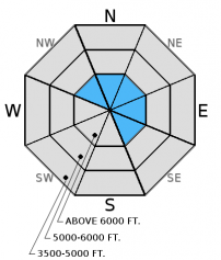
For 5000 ft. to 7000 ft.
Monday Monday Night Tuesday
Cloud Cover: Light snow showers increasing late afternoon. Gusty winds. Moderate snow. Continued snow with gusty winds.
Temperatures: 24-33 deg. F. 17-24 deg. F. 21-30 deg. F.
Wind Direction: S-SW S-SE W-SW
Wind Speed: 10-14 gusts 21-29 9-13 gusts 21-31 10-16 gusts 25-29
Snowfall: 1 in. 5-8 in. 2-5 in.
Snow Line:
Disclaimer

This advisory applies only to backcountry areas outside established ski area boundaries. This advisory describes general avalanche conditions and local variations always occur. This advisory expires at midnight on the posted day unless otherwise noted. The information in this advisory is provided by the USDA Forest Service who is solely responsible for its content.