| Sunday | Sunday Night | Monday | |
|---|---|---|---|
| Cloud Cover: | Isolated light snow showers, increasing late in the afternoon. | Snow with increasing winds. | Snow showers. |
| Temperatures: | 23-31 deg. F. | 18-24 deg. F. | 23-31 deg. F. |
| Wind Direction: | SW | SW | SW |
| Wind Speed: | 3-9 gusts 21-24 | 11-15 gusts 23-32 | 11-19 gusts 21-39 |
| Snowfall: | 0-1 in. | 2-5 in. | 1-3 in. |
| Snow Line: |
Swan Range
How to read the forecast
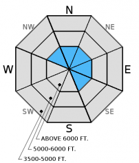
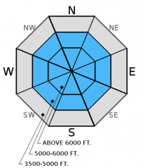
Today the avalanche danger is CONSIDERABLE above 6000 feet on wind loaded slopes steeper than 35º. In this terrain, where existing wind slabs have not had time to settle and the consistent load continues to stress deeper instabilities, human triggered avalanches are likely. In other terrain the danger is MODERATE. Carefully evaluate the snowpack and terrain before committing to any slope.

3. Considerable
?
Above 6500 ft.
2. Moderate
?
5000-6500 ft.
2. Moderate
?
3500-5000 ft.
- 1. Low
- 2. Moderate
- 3. Considerable
- 4. High
- 5. Extreme
-
Type ?
-
Aspect/Elevation ?

-
Likelihood ?CertainVery LikelyLikelyPossible
 Unlikely
 -
Size ?HistoricVery LargeLargeSmall

Though wind speeds moderated yesterday and into last night it can take wind slabs several days to gain strength. We observed very sensitive wind slabs in the Swan Range on Friday, and with the additional weight in the past 24 hours I still dont trust that they have gained much strength. Continue to carefully evaluate wind-loaded areas before skiing or riding the slope. Wind slabs are easy to identify, look for smooth, convex pillows along leeward ridgelines and cross-loaded gullies. Pay attention to obvious signs of instability like cracking or collapsing.
-
Type ?
-
Aspect/Elevation ?

-
Likelihood ?CertainVery LikelyLikelyPossible
 Unlikely
 -
Size ?HistoricVery LargeLargeSmall

The primary persistent slab concern is the weak, faceted snow below the Dec. 9 crust. This layer is generally found 2-2.5 feet from the surface and exists in most locations across the advisory area. So far, we have not seen avalanche activity associated with this weak snow, but it is hard to say just how much weight it can handle. Continue to dig into the snow and assess this layer before committing to a slope and keep in mind the additional stress we put on this weak snow as we continue in our active weather pattern.
In some locations in the Flathead Range, Glacier Park, and parts of the Swan Range we noted and have received observations of weak, sugary snow near the ground. In some places it breaks and propagates across a column in stability tests (video), and sometimes it doesn't even break. These faceted grains are generally found in areas of thin snowpack and around rocks. With the December 9 rain crust fairly thick in places, it makes affecting these deeper layers more difficult.
Yesterday, Mark was instructing an Intro to Avalanches course just outside of the ski area boundary and found recent storm snow that was settling and strengthening. They noted that weak, faceted snow was present below mid-snowpack crusts and failed in stability tests with moderate force.
On Friday, Erich and I rode into the Lost Johnny drainage and skied up Hash Mountain where we observed obvious signs of storm and wind slab instability including: cracking, collapsing, and we triggered a couple of soft slab avalanches (photo) from the ridgeline above (Observation, Video).
Skiers on lower Elk Mountain in the Flathead Range found a shallow snowpack (70cm) and unconsolidated recent snow on top of the rain crust. With the warming that occured, they noted an "upside down" storm layer forming in the 8-10 inches of new snow. They did not observe any obvious signs of instability, but they also found depth hoar present in this location.
Thursday, before the storm, Erich and I skied into the backcountry east of the boundary of Whitefish Mountain Resort to the Chicken Bones area. We found a relatively strong snowpack with no facets near the ground, but weak snow below the December 9 rain crust made us think about how the incoming storm will interact with it (video, observation).
Skiers on Elk Mt. (observation) and another party on False Shields (Peak 7798) in southern Glacier Park yesterday found mostly unconsolidated surface snow (read: powder) with thin wind slab development just near ridgetops. Stability tests showed mixed results with deeper instabilities.
Visit our Observations page and our You Tube channel for more information from the entire season.
Please let us know what you are seeing out there. Your observations are important and valued.
HOW TO SUBMIT OBSERVATIONS:
Email: [email protected]
Call and leave a message: 406.387.3821
You can also submit quick observations via text: 406.241.4571 (FAC mobile)
OR
Submit Snowpack Observations: http://www.flatheadavalanche.org/node/add/snowobs
Submit Avalanche Observations: http://www.flatheadavalanche.org/node/add/avyobs
It feels like winter has returned to Northwest Montana. We picked up an additional 1-5 inches of snow in the last 24 hours and the forecast looks like we should continue to get more through the coming week. The Swan Range was favored in yesterday's system, Noisy Basin SNOTEL recorded 5 inches of snow and 0.7 inches of snow water equivalent (SWE). Other locations across the advisory area recorded 0.15-.3 inches of SWE and 2-4 inches of snow. Currently, temperatures above 6000 feet range from 17º-23ºF and winds are out of the southwest at 3-7 mph with gusts of 5-15 mph. Today, expect snow showers to diminish this morning and resume late in the afternoon. Temperatures will be in the low to mid 20s with winds out of the southwest at 5-15 mph.
| 0600 temperature: | 17-23 deg. F. |
| Max. temperature in the last 24 hours: | 23-28 deg. F. |
| Average wind direction during the last 24 hours: | SW |
| Average wind speed during the last 24 hours: | 3-7 mph |
| Maximum wind gust in the last 24 hours: | 5-15 mph |
| New snowfall in the last 24 hours: | 1-5 inches |
| Total snow depth: | 43-56 inches |
This advisory applies only to backcountry areas outside established ski area boundaries. This advisory describes general avalanche conditions and local variations always occur. This advisory expires at midnight on the posted day unless otherwise noted. The information in this advisory is provided by the USDA Forest Service who is solely responsible for its content.


