| Thursday | Thursday Night | Friday | |
|---|---|---|---|
| Cloud Cover: | Transition day before a moist storm enters the area tonight. | Relatively wet storm enters the region. | Snow, wind, and rising temps. |
| Temperatures: | 18 to 26 deg. F. | 13 to 20 deg. F. | 28 to 36 deg. F. |
| Wind Direction: | West-Southwest | Southwest | Southwest |
| Wind Speed: | 4-8 mph with gusts to 20 mph. | 5-10 mph | 10-15 mph with gusts to 35 mph. |
| Snowfall: | 0 in. | 2-4 in. | 3-7 in. |
| Snow Line: |
Whitefish Range
Swan Range
Flathead Range and Glacier National Park
How to read the forecast
The avalanche danger above 6000 feet is CONSIDERABLE on wind loaded slopes steeper than 35 degrees and MODERATE on all other terrain. Up to 16 inches of snow fell across the advisory area (favoring the Swan Range) Tuesday into Wednesday. Steep, wind-loaded terrain at upper elevations still requires careful snowpack evaluation and cautious route-finding. Also, identify features of concern like steep, rocky, shallow areas that harbor weak, sugary snow near the ground.

3. Considerable
?
Above 6500 ft.
2. Moderate
?
5000-6500 ft.
1. Low
?
3500-5000 ft.
- 1. Low
- 2. Moderate
- 3. Considerable
- 4. High
- 5. Extreme
-
Type ?
-
Aspect/Elevation ?

-
Likelihood ?CertainVery LikelyLikelyPossible
 Unlikely
 -
Size ?HistoricVery LargeLargeSmall

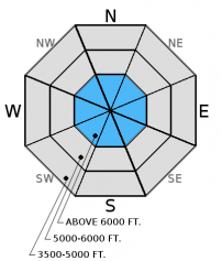
Winds from the north-northeast yesterday have likely formed wind slabs near ridges and in cross-loaded gullies in the alpine in atypical locations for our area. Since winds have switched direction again, you may be able to find wind slabs on many aspects today. These slabs coud be up to 2 feet deep in locations where the most snow fell. Wind slabs can take up to a week to stabilize after formation. In wind loaded areas, up to 3 feet of snow now exists above the December 9 rain crust. This crust could provide a good sliding surface for these slabs. Look for convex pillows of wind drifted snow, particularly near ridges.
-
Type ?
-
Aspect/Elevation ?

-
Likelihood ?CertainVery LikelyLikelyPossible
 Unlikely
 -
Size ?HistoricVery LargeLargeSmall

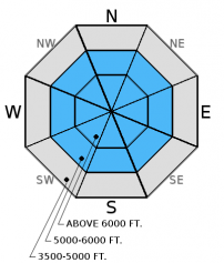
Weak, sugary snow (facets) near the ground exists in parts of our advisory area. This layer does not appear to be present everywhere, but in enough places that it warrants attention. While we have not observed or received reports of avalanches breaking on this layer, I list it as a problem because I still don't trust it based on our stability test results. Because of the geographic spottiness of this layer, we've seen mixed results in stability tests. In some places it breaks and fails in tests, and sometimes it doesn't even break. These faceted grains near the ground are generally found in areas of thin snowpack and around rocks and brush. This is where you are more likely to trigger an avalanche on this layer. With the December 9 rain crust fairly thick in places, it makes affecting these deeper layers more difficult, but still possible. There is also weak snow forming above and below this rain crust that has broken and propagated in our stability tests. Pay attention to signs of instability like cracking, collapsing, "whumpfing", and, of course, recent avalanche activity.
Skiers in the southern Whitefish Range yesterday reported good skiing with about 14-16 inches of total snow above the December 9 rain crust. They traveled on non-wind loaded slopes and stuck to slopes mostly less than 35 degrees. They observed no cracking or collapsing of the snowpack during their travels.
On Tuesday, Mark and his partners rode into Noisy Basin where he observed a relatively shallow snowpack with weak, sugary snow near the ground. The December 9 rain crust on an east aspect was nearly 8 inches thick in one of their pits. BNSF Snow Safety found moist, weak snow near the ground in a very shallow snowpack on Tuesday as well, but it did not propagate in their stability tests (observation).
On Monday, I toured into the Marion Lake area of the Flathead Range where I was able to affect this weak snow at the bottom of the snowpack with hard force in stability tests (photo,video, observation) despite the December 9 rain crust.
Visit our Observations page for more information from the entire season.
Please let us know what you are seeing out there. Your observations are important and valued.
HOW TO SUBMIT OBSERVATIONS:
Email: [email protected]
Call and leave a message: 406.387.3821
You can also submit quick observations via text: 406.241.4571 (FAC mobile)
OR
Submit Snowpack Observations: http://www.flatheadavalanche.org/node/add/snowobs
Submit Avalanche Observations: http://www.flatheadavalanche.org/node/add/avyobs
The recent storm dropped 6-16 inches of snow (0.3 to 1.1 inches of snow water equivalent) Tuesday night through mid-day Wednesday with the Swan Range receiving the lion's share of precipitation. Winds switched to the northeast yesterday and picked up to 10-15 mph with gusts to 23 mph. They have since switched back to the west this morning at 2-8 mph with gusts to 15 mph. As of 4 a.m. temperatures readings above 6000 feet ranged from 3º to 11º F. Today, temperatures should be in the low 20s F with southwest winds at 5-15 mph with gusts to 30 mph closer to the Continental Divide. Tonight, warmer air in the upper atmosphere will move into the region. Snow will begin tonight and continue through the day Friday.
*Noisy Basin SNOTEL has not reported since midnight last night so our data from there is not current.
| 0600 temperature: | 3-11 deg. F. |
| Max. temperature in the last 24 hours: | 14-21 deg. F. |
| Average wind direction during the last 24 hours: | Northeast switching to West |
| Average wind speed during the last 24 hours: | 8-13 mph |
| Maximum wind gust in the last 24 hours: | 15-23 mph |
| New snowfall in the last 24 hours: | 0-4 inches |
| Total snow depth: | 31-51 inches |
This advisory applies only to backcountry areas outside established ski area boundaries. This advisory describes general avalanche conditions and local variations always occur. This advisory expires at midnight on the posted day unless otherwise noted. The information in this advisory is provided by the USDA Forest Service who is solely responsible for its content.


