| Wednesday | Wednesday Night | Thursday | |
|---|---|---|---|
| Cloud Cover: | Snowfall tapering by late morning. | A bit of clearing and getting colder overnight. | Mostly cloudy |
| Temperatures: | 20 to 29 deg. F. | -8 to 12 deg. F. | 16-24 deg. F. |
| Wind Direction: | NNE | NW | SW |
| Wind Speed: | 5-10 mph | 5-10 mph | 3-10 mph |
| Snowfall: | 1-3 in. | 0 in. | 0 in. |
| Snow Line: |
Swan Range
How to read the forecast
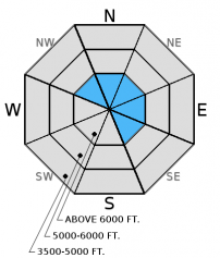
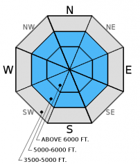
Today, the avalanche danger above 6000 feet in the Swan Range is CONSIDERABLE on all slopes and MODERATE elsewhere. The Swan Range received 9 inches with more n the way, and the spotty presence of deeper weak layers across our area along with new snow and wind requires careful snowpack evaluation and cautious route-finding. Pay attention to recently wind-loaded slopes as well as areas where weak snow deeper in the snowpack can be more easily triggered.

3. Considerable
?
Above 6500 ft.
2. Moderate
?
5000-6500 ft.
2. Moderate
?
3500-5000 ft.
- 1. Low
- 2. Moderate
- 3. Considerable
- 4. High
- 5. Extreme
-
Type ?
-
Aspect/Elevation ?

-
Likelihood ?CertainVery LikelyLikelyPossible
 Unlikely
 -
Size ?HistoricVery LargeLargeSmall

Cotinuing light, new snow throughout the morning combined with moderate west-southwest winds will form wind slabs at upper elevations. Though, with shifting wids coming from the north-northeast we could begin to see wind slab formation in atypical locations. Wind slabs are likely to form near ridges and in cross-loaded gullies and up to 1.5 feet deep in locations where the most snow fell. These new wind slabs may also be masking lingering wind slabs from last weekend's snow. Wind slabs can take up to a week to stabilize after formation. The rain crust formed earlier in the week reaches into high elevations (around 7000-7500 feet) and could provide a good sliding surface for these slabs.
-
Type ?
-
Aspect/Elevation ?

-
Likelihood ?CertainVery LikelyLikelyPossible
 Unlikely
 -
Size ?HistoricVery LargeLargeSmall

We, and others, observed weak, sugary snow (facets) near the ground in parts of our advisory area. This layer does not appear to be present everywhere, but in enough places that it warrants attention. Because of the geographic spottiness of this layer, we've seen mixed results in stability tests. In some places it breaks and fails in tests, and sometimes it doesn't even break. These faceted grains near the ground are generally found in areas of thin snowpack and around rocks and brush. This is where you are more likely to trigger an avalanche on this layer. So, pay close attention to steep, rocky areas with a shallow snowpack. With the December 9 rain crust fairly thick in places, it makes affecting these deeper layers more difficult, but still possible. There is also weak snow forming above and below this rain crust that has broken and propagated in our stability tests. Pay attention to signs of instability like cracking, collapsing, "whumpfing", and, of course, recent avalanche activity.
Yesterday, Mark and his partners rode into Noisy Basin where he observed a relatively shallow snowpack with weak, sugary snow near the ground. The December 9 rain crust on an east aspect was nearly 8 inches thick in one of their pits. However, the weak snow near the ground broke and propagated in stability tests. Illustrating the spotty nature of the weak snow near the ground, BNSF Snow Safety found this layer in a very shallow snowpack, but it did not propagate in their stability tests (observation).
On Monday, I toured into the Marion Lake area of the Flathead Range where I was able to affect this weak snow at the bottom of the snowpack with hard force in stability tests (photo,video, observation) despite the December 9 rain crust.
On Sunday just after the most recent storm in Canyon Creek, on east - northeast aspects, an experienced backcountry skier reported triggering 2 soft slab avalanches remotely from the flatter terrain above the slide paths. He reported the snowpack in this location as sensitive. A separate party of skiers submitted photos of this recent avalanche activity just outside the ski area boundary (photo). Skiers in the Stryker Ridge area of the Whitefish Range on Sunday reported snow pack failure in their stability tests (observation).
Please let us know what you are seeing out there. Your observations are important and valued.
HOW TO SUBMIT OBSERVATIONS:
Email: [email protected]
Call and leave a message: 406.387.3821
You can also submit quick observations via text: 406.241.4571 (FAC mobile)
OR
Submit Snowpack Observations: http://www.flatheadavalanche.org/node/add/snowobs
Submit Avalanche Observations: http://www.flatheadavalanche.org/node/add/avyobs
Since yesterday evening, mountain weather stations across the advisory area report 4-9 inches of relatively light new snow (0.2-0.6 inches of snow water equivalent) favoring the Swan Range. Noisy Basin SNOTEL in the Swan Range reports about 9 inches of new snow (0.6 inches of SWE) . Winds were moving out of the west-southwest at 5-10 mph gusting to 20 mph yesterday evening and overnight. Snowfall will taper through the morning with an additional 2-3 inches expected at upper elevations today. As of 4 a.m. temperature readings above 6000 feet ranged from 14º-21º F with west-southwest winds at 4-8 mph and gusts to 20 mph. Temperatures should be in the low 20s F with winds shifting to the north-northeast today.
As an aside, while the lower elevations are struggling for snowpack, the upper elevations aren't terrible. Remember, it is still only mid-December. For December 16, Stahl Peak SNOTEL in the Whitefish Range is at 98% of median snow water equivalent. Flattop Mt. SNOTEL in Glacier NP is at 86% of median snow water equivalent, and Noisy Basin SNOTEL in the Swan Range could use a little help and is at 60% of median snow water equivalent.
| 0600 temperature: | 14-21 deg. F. |
| Max. temperature in the last 24 hours: | 15-23 deg. F. |
| Average wind direction during the last 24 hours: | WSW |
| Average wind speed during the last 24 hours: | 4-8 mph |
| Maximum wind gust in the last 24 hours: | 19-23 mph |
| New snowfall in the last 24 hours: | 4-7 inches |
| Total snow depth: | 30-51 inches |
This advisory applies only to backcountry areas outside established ski area boundaries. This advisory describes general avalanche conditions and local variations always occur. This advisory expires at midnight on the posted day unless otherwise noted. The information in this advisory is provided by the USDA Forest Service who is solely responsible for its content.


