| Sunday | Sunday Night | Monday | |
|---|---|---|---|
| Cloud Cover: | Snow showers and moderate-strong winds. | Showers with decreasing wind. | Cooler, decreasing showers. |
| Temperatures: | 28-37 deg. F. | 17-24 deg. F. | 24-33 deg. F. |
| Wind Direction: | SW | W | W |
| Wind Speed: | 13-17 gusts 29-36 | 6-8 | 5 |
| Snowfall: | 3-4 in. | 1-3 in. | 1-2 in. |
| Snow Line: |
Whitefish Range
Swan Range
Flathead Range and Glacier National Park
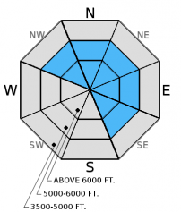
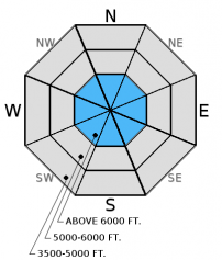
How to read the forecast
Today, the avalanche danger above 6000 feet is CONSIDERABLE on wind-loaded slopes and all slopes steeper than 35º. In other terrain the danger is MODERATE. New snow accompanied by moderate winds overnight formed fresh wind slabs on leeward and cross-loaded slopes. Dangerous avalanche conditions exist in steep and wind loaded terrain, cautious route-finding and conservative decision making are essential while traveling at upper elevations.

3. Considerable
?
Above 6500 ft.
2. Moderate
?
5000-6500 ft.
2. Moderate
?
3500-5000 ft.
- 1. Low
- 2. Moderate
- 3. Considerable
- 4. High
- 5. Extreme
-
Type ?
-
Aspect/Elevation ?

-
Likelihood ?CertainVery LikelyLikelyPossible
 Unlikely
 -
Size ?HistoricVery LargeLargeSmall

3-8 inches of snow fell overnight and was accompanied by moderate winds with strong gusts. New snow in addition to snow from Friday could translate to 2-3 foot windslabs in the upper-elevations. The rain crust formed earlier in the week reaches into high elevations (above 7000 feet) and will provide an excellent sliding surface for new slabs. It is important to carefully evaluate each slope you intend to ski or ride. Look for convex pillows of wind drifted snow on the lee sides of ridges and gullies. Pay attention to signs of instability like cracking, collapsing, "whumpfing", and, of course, recent avalanche activity.
-
Type ?
-
Aspect/Elevation ?

-
Likelihood ?CertainVery LikelyLikelyPossible
 Unlikely
 -
Size ?HistoricVery LargeLargeSmall

Our data from alpine slopes across the advisory area are still limited, but we do continue to find weak snow in most of our field observations and until we can rule it out as a problem it will be included. In most areas, the storm earlier in the week was a good test for the persistent weak layers including the weak, sugary snow (facets) above the mid-November rain crust or the early December melt-freeze crust on sunny aspects. However, as we found Friday near the Continental Divide the snow pack did not get as rigorous of a test and weak snow structure persists. The silver lining to the shallow snowpack is that it is easy to dig all the way to the ground and see what is going on below you, and please let us know what you find. Shallow, early season snowpacks have surprised many in the past.
The lowest elevation band (3500-5000 feet) has no to very little snow making travel and subsequent access to the upper elevations difficult in certain areas. However, as you approach the upper end of this elevation band and begin to encounter more snow, then treat those slopes as you would terrain in the mid- and upper elevation bands.
Yesterday, we rode into the Lost Johnny drainage near Hash Mountain in the Swan Range. The general snowpack structure was similar to recent findings in the southern Whitefish Range. The snow depth at 6900 feet was 3.5 feet (image). Weak snow is in the early phases of development above the December 9 rain crust as was also noted above the mid-November crust.
Friday, we were in the Skyland area in the Flathead Range. At nearly 7000 feet the snowpack was a meager 2.5 feet, and 6 inches of that had fallen in the previous 24 hours. Due to such shallow snow the overall structure was very weak. We found weak, faceted snow above and below the mid-November crust, as well as large grained depth hoar near the ground (Photo). The surface was similar to other areas with 6 inches of recent snow atop a supportable rain crust.
Erich was on Skookoleel Ridge in the southern Whitefish Range on Friday and also found weak snow above the mid-November crust, as well as surface hoar 50 cm below the surface.
Please let us know what you are seeing out there. Your observations are important and valued.
HOW TO SUBMIT OBSERVATIONS:
Email: [email protected]
Call and leave a message: 406.387.3821
You can also submit quick observations via text: 406.241.4571 (FAC mobile)
OR
Submit Snowpack Observations: http://www.flatheadavalanche.org/node/add/snowobs
Submit Avalanche Observations: http://www.flatheadavalanche.org/node/add/avyobs
Overnight we picked up an additional 2-8 inches of snow (0.2-0.6 inches snow water equivalent). Winds increased early this morning out of the southwest with gusts up to 40 mph. Currently, temperatures above 6000 feet range from 22º-27º F and winds are out of the southwest at 6-15 mph with gusts from 11-40 mph. For today, expect snow showers to continue this morning and taper in the afternoon. Winds will continue out of the southwest at 10-20 mph with stronger gusts on the ridges and temperatures will remain in the high 20s to low 30s.
| 0600 temperature: | 22-27 deg. F. |
| Max. temperature in the last 24 hours: | 22-28 deg. F. |
| Average wind direction during the last 24 hours: | SW |
| Average wind speed during the last 24 hours: | 5-10 mph |
| Maximum wind gust in the last 24 hours: | 15-25 mph |
| New snowfall in the last 24 hours: | 2-8 inches |
| Total snow depth: | 26-49 inches |
This advisory applies only to backcountry areas outside established ski area boundaries. This advisory describes general avalanche conditions and local variations always occur. This advisory expires at midnight on the posted day unless otherwise noted. The information in this advisory is provided by the USDA Forest Service who is solely responsible for its content.


