| Saturday | Saturday Night | Sunday | |
|---|---|---|---|
| Cloud Cover: | Light snow showers. | Increasing snow showers and wind. | Continued snow and gusty winds. |
| Temperatures: | 27-36 deg. F. | 22-28 deg. F. | 29-38 deg. F. |
| Wind Direction: | S-SW | S-SW | S-SW |
| Wind Speed: | 4-5 | 12-14 gusts 28-29 | 13-17 gusts 25-33 |
| Snowfall: | 0-1 in. | 2-5 in. | 3-5 in. |
| Snow Line: |
Whitefish Range
Swan Range
Flathead Range and Glacier National Park
How to read the forecast
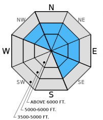
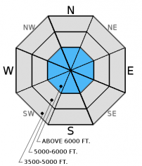
The avalanche danger is MODERATE above 5000 feet. Human triggered avalanches are possible, particularly on recently wind loaded slopes and in steep terrain with shallow snow. Due to the limited data in the alpine, keep in mind that you may encounter areas of higher hazard than expected. Carefully evaluate the snow pack and terrain before commiting to any slope.

2. Moderate
?
Above 6500 ft.
2. Moderate
?
5000-6500 ft.
1. Low
?
3500-5000 ft.
- 1. Low
- 2. Moderate
- 3. Considerable
- 4. High
- 5. Extreme
-
Type ?
-
Aspect/Elevation ?

-
Likelihood ?CertainVery LikelyLikelyPossible
 Unlikely
 -
Size ?HistoricVery LargeLargeSmall

Strong winds combined with a bit of new snow over the past few days created wind slabs at upper elevations. On Wednesday, Erich noted plumes of snow coming off of the peaks and ridge tops in the Whitefish Range at elevations above the rain level (~7000 feet). At elevations below this, the new snow sits atop a slippery rain crust (Dec. 9). Even though these recently formed slabs have had a couple of days to settle and bond to the slick bed surface that they were formed on, it remains important to assess each wind-loaded slope for lingering instability. Observations from alpine areas are limited so it is important when travelling in upper-elevation terrain to carefully evaluate each slope you intend to ski or ride. Look for convex pillows of wind drifted snow on the lee sides of ridges and gullies. In areas above the Dec. 9 rain level the wind slabs could be 2-3 feet deep. Pay attention to signs of instability like cracking, collapsing, "whumpfing", and, of course, recent avalanche activity.
-
Type ?
-
Aspect/Elevation ?

-
Likelihood ?CertainVery LikelyLikelyPossible
 Unlikely
 -
Size ?HistoricVery LargeLargeSmall

Our data from alpine slopes across the advisory area are still limited, but we do continue to find weak snow in most of our field observations and until we can rule it out as a problem it will be included. In most areas, the recent storm was a good test for the persistent weak layers including the weak, sugary snow (facets) above the mid-November rain crust or the early December melt-freeze crust on sunny aspects. However, as we found yesterday near the Continental Divide the snow pack did not get as rigorous of a test and weak snow structure persists. The silver lining to the shallow snowpack is that it is easy to dig all the way to the ground and see what is going on below you, and please let us know what you find. Shallow, early season snowpacks have surprised many in the past. It is easy to become complacent when travelling on top of a supportable crust, but remember as soon as you punch through that it will be possible to affect underlying instabilities.
The lowest elevation band (3500-5000 feet) has no to very little snow making travel and subsequent access to the upper elevations difficult in certain areas. However, as you approach the upper end of this elevation band and begin to encounter more snow, then treat those slopes as you would terrain in the mid- and upper elevation bands.
Yesterday, we were in the Skyland area in the Flathead Range. Being my first trip out there for the season, I was surprised by the lack of snow. At nearly 7000 feet the snowpack was a meager 2.5 feet, and 6 inches of that had fallen in the previous 24 hours. Due to such shallow snow the overall structure was very weak. We found weak, faceted snow above and below the mid-November crust, as well as large grained depth hoar near the ground (Photo). The surface was similar to other areas with 6 inches of recent snow atop a supportable rain crust.
Erich was on Skookoleel Ridge in the southern Whitefish Range yesterday and also found weak snow above the mid-November crust, as well as surface hoar 50 cm below the surface.
Skiers on Radio Ridge in the Swan Range yesterday reported 4 inches of new snow on top of a supportable crust.
On Thursday, myself and another separate party were at Ghoulie Point in the southern Whitefish Range (observations). Weak snow has already formed underneath the new rain crust, and I suspect it will begin to form above that crust, too (image). It is also worth mentioning that I found decomposing surface hoar about 16 inches below the surface in a snow pit.
Please let us know what you are seeing out there. Your observations are important and valued.
HOW TO SUBMIT OBSERVATIONS:
Email: [email protected]
Call and leave a message: 406.387.3821
You can also submit quick observations via text: 406.241.4571 (FAC mobile)
OR
Submit Snowpack Observations: http://www.flatheadavalanche.org/node/add/snowobs
Submit Avalanche Observations: http://www.flatheadavalanche.org/node/add/avyobs
Only an inch of new snow (0.05-0.2 inches snow water equivalent) fell in the past 24 hours, but given the season so far we'll take it. Currently, mountain temperatures range from 20º-28º F and winds are out of the southwest at 2-5 mph with gusts from 7-10 mph. Today, we could see some lingering snow showers ahead of the next system that is expected to move into the area tonight. Temperatures should remain in the upper 20s to low 30s F with winds 5-10 mph out of the southwest.
| 0600 temperature: | 20-28 deg. F. |
| Max. temperature in the last 24 hours: | 21-29 deg. F. |
| Average wind direction during the last 24 hours: | SW |
| Average wind speed during the last 24 hours: | 5-10 mph |
| Maximum wind gust in the last 24 hours: | 10-27 mph |
| New snowfall in the last 24 hours: | 0-1 inches |
| Total snow depth: | 25-44 inches |
This advisory applies only to backcountry areas outside established ski area boundaries. This advisory describes general avalanche conditions and local variations always occur. This advisory expires at midnight on the posted day unless otherwise noted. The information in this advisory is provided by the USDA Forest Service who is solely responsible for its content.


