| Thursday | Thursday Night | Friday | |
|---|---|---|---|
| Cloud Cover: | Light to moderate snowfall beginning around mid-day. | Continued light snowfall overnight. | Mild with light snow in the morning. |
| Temperatures: | 29-38 deg. F. | 22-28 deg. F. | 28-36 deg. F. |
| Wind Direction: | South | Southwest | Southwest |
| Wind Speed: | 5-10 mph. | 10-15 mph with gusts to 35 mph. | 5-15 mph with gusts to 30 mph. |
| Snowfall: | 1-2 in. | 1-3 in. | 0-1 in. |
| Snow Line: |
Whitefish Range
Swan Range
Flathead Range and Glacier National Park
How to read the forecast
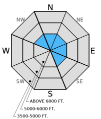
The danger on wind loaded slopes above 6000 feet is CONSIDERABLE, and human triggered avalanches are likely. Careful snowpack evaluation and cautious route-founding are essential in these areas. The danger on all other slopes is MODERATE where triggering an avalanche is possible. Strong southwest winds created wind slabs on leeward and cross-loaded slopes and gullies. Most of these slopes are confined to above 6000 feet, but treat all wind loaded slopes as suspect prior to traveling on them.

3. Considerable
?
Above 6500 ft.
2. Moderate
?
5000-6500 ft.
1. Low
?
3500-5000 ft.
- 1. Low
- 2. Moderate
- 3. Considerable
- 4. High
- 5. Extreme
-
Type ?
-
Aspect/Elevation ?

-
Likelihood ?CertainVery LikelyLikelyPossible
 Unlikely
 -
Size ?HistoricVery LargeLargeSmall

Wind speeds in the 20-30 mph range with gusts up to 82 mph for most of the day yesterday created wind slabs at upper elevations. Though the snow level was rather high yesterday (~6000-7000 feet), it snowed above that and plumes of snow could be seen coming off of the peaks and ridge tops yesterday in the Whitefish Range. Look for convex pillows of wind drifted snow on the lee sides of ridges and gullies, and avoid wind loaded slopes today. Expect these wind slabs to be sensitive to human triggering and 1-3 feet deep. Today's expected new snow will only add to the wind slab depth. Look for signs of instability like cracking, collapsing, "whumpfing", and, of course, recent avalanche activity.
The most recent storm from 12/6 to 12/9 packed quite a punch in the moisture department! It looked more like April spring runoff than it did December with brown, swollen rivers and creeks. This was a good test to the snowpack including persistent weak layers like the mid-November rain crust. Based on limited observations from yesterday, most of the natural avalanche activity failed on the new and old snow interface with 12-16 inch crowns. Though, it would still be wise to treat the mid-November crust (and the weak snow above it) as suspect until you can determine otherwise. We still don't have detailed information about upper elevations slopes across the advisory area so pay attention to obvious signs of instability.
Generally, since temperatures have cooled this will help stabilize the snowpack at elevations where it rained. However, the transition from a frozen snow surface to a cold, winter snowpack could be abrupt above 6000 feet. So, pay close attention to changing snow conditions as you climb in elevation today. The lowest elevation band (3500-5000 feet) has no to very little snow making travel and subsequent access to the upper elevations difficult in certain areas. However, as you approach the upper end of this elevation band and begin to encounter more snow, then treat those slopes as you would terrain in the mid- and upper elevation bands.
It was a wet and windy one out there yesterday. We safely traveled to Red Meadow Lake in the northern Whitefish Range. We stayed off of and out from under steep slopes. We observed numerous slab avalanches at and above the 6000 ft. elevation level (image) including two smaller ones in the path that crosses the road west of the lake . It did not reach the road due to the brush still poking out. However, one large avalanche traveled 1600-1800 vertical feet, mowing over brush, and depositing debris into the lake (video and observation).
Your observations are important, especially now after this storm to determine if the storm hit the reset button or if there is still a persistent slab problem out there.
HOW TO SUBMIT OBSERVATIONS:
Email: [email protected]
Call and leave a message: 406.387.3821
You can also submit quick observations via text: 406.241.4571 (FAC mobile)
OR
Submit Snowpack Observations: http://www.flatheadavalanche.org/node/add/snowobs
Submit Avalanche Observations: http://www.flatheadavalanche.org/node/add/avyobs
That was a wet storm! Precipitation amounts across the advisory area at upper elevation weather stations range from 2.5 to 4.1 inches of liquid water. It first fell as snow when it began on December 6, then transitioned to rain before it ended yesterday. Currently, mountain weather stations report temperatures from 20º-28º F with winds out of the southwest at 5-10 mph gusting to 17 mph. For today into tomorrow, expect 3-6 inches of snow above 4500 feet with winds out of the south at 5-10 mph with gusts to 15 mph.
| 0600 temperature: | 20-28 deg. F. |
| Max. temperature in the last 24 hours: | 33-39 deg. F. |
| Average wind direction during the last 24 hours: | Southwest |
| Average wind speed during the last 24 hours: | 16-52 mph |
| Maximum wind gust in the last 24 hours: | 42-82 mph |
| New snowfall in the last 24 hours: | 0-1 inches |
| Total snow depth: | 20-39 inches |
This advisory applies only to backcountry areas outside established ski area boundaries. This advisory describes general avalanche conditions and local variations always occur. This advisory expires at midnight on the posted day unless otherwise noted. The information in this advisory is provided by the USDA Forest Service who is solely responsible for its content.


