| Thursday | Thursday Night | Friday | |
|---|---|---|---|
| Cloud Cover: | Snow showers | Light snow showers and partial clearing | Continued showers |
| Temperatures: | 34-45 deg. F. | 21-27 deg. F. | 36-45 deg. F. |
| Wind Direction: | west | west/southwest | southwest |
| Wind Speed: | 7-8 gusts 21-23 | 7-8 gusts 21-22 | 9-11 gusts 21-22 |
| Snowfall: | 1-2 in. | 0-1 in. | 0-1 in. |
| Snow Line: |
Whitefish Range
Swan Range
Flathead Range and Glacier National Park
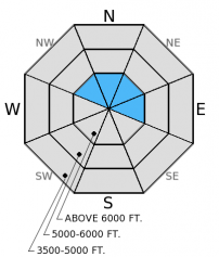
How to read the forecast
Several nights with a strong re-freeze reduced the potential for wet avalanches. The avalanche hazard today is LOW, and generally safe conditions exist. Continue to pay attention to rapidly changing weather conditions, and practice safe backcountry travel technique like only exposing one person at a time to avalanche terrain.

1. Low
?
Above 6500 ft.
1. Low
?
5000-6500 ft.
1. Low
?
3500-5000 ft.
- 1. Low
- 2. Moderate
- 3. Considerable
- 4. High
- 5. Extreme
-
Type ?
-
Aspect/Elevation ?

-
Likelihood ?CertainVery LikelyLikelyPossible
 Unlikely
 -
Size ?HistoricVery LargeLargeSmall

The wind slab problem should be one that only people traveling in the highest elevations will encounter. Even in the upper reaches these slabs should be fairly thin and manageble. Be sure to assess these slopes for recent wind slabs and avoid steep, consequential terrain where they are present.
Additional Concerns: Longer days and warmer temperatures may cause large cornices to weaken and fail. It is the time of year to avoid traveling below cornices and stay well behind them while traveling along ridgelines as they can break farther back than expected.
NOTE: Ortovox is recalling the S1+ avalanche transceiver. More info: http://www.ortovox.com/4875--handling_recall.html
The next regularly scheduled advisory will be issued Saturday, April 4, 2015. The final avalanche advisory of the season will be issued Sunday, April 5, 2015.
Finally a few nights with a solid re-freeze. For the past two nights temperatures dropped below freezing, which benefited the snow pack by forming a solid crust on the surface and halted the flow of water through the snow. Yesterday, we were in the Half Moon area in the southern Whitefish Range where the surface crust easily supported our weight on skis (photo). Ridgetop winds were only drifting the small amount of snow (less than an inch) from the previous night. When visibility allowed, we noted plumes of snow drifting on the highest peaks in the distance.
Yesterday, skiers in the Ghoulie's area, also in the southern Whitefish Range found a solid snow surface and observed a small amount of wind drifting (observation).
An unsettled weather pattern for the past few days brought cooler temperatures, moderate to strong winds, and snow showers. In the past 24 hours high temperatures remained near the freezing the mark in most locations. SNOTEL sites stopped reporting at 1:00 this morning, but before that time they reported 0-2 inches of snow. Currently, mountain temperatures range from 18-25º F and winds are out of the west/northwest 3-5 mph with gusts to 7 mph. Expect mostly cloudy skies today with temperatures reaching the mid-30s and westerly winds at 5-15 mph. Scattered light snow showers should continue today and linger through the night.
| 0600 temperature: | 16-25 deg. F. |
| Max. temperature in the last 24 hours: | 25-42 deg. F. |
| Average wind direction during the last 24 hours: | SW |
| Average wind speed during the last 24 hours: | 5-15 mph |
| Maximum wind gust in the last 24 hours: | 15-35 mph |
| New snowfall in the last 24 hours: | 0-2 inches |
| Total snow depth: | 58-97 inches |
This advisory applies only to backcountry areas outside established ski area boundaries. This advisory describes general avalanche conditions and local variations always occur. This advisory expires at midnight on the posted day unless otherwise noted. The information in this advisory is provided by the USDA Forest Service who is solely responsible for its content.


