| Tuesday | Tuesday Night | Wednesday | |
|---|---|---|---|
| Cloud Cover: | Precipitation moves into region and cold front passes later today. Winds becoming strong. | Cold front causes temperatures to lower with continued intermittent precipitation. | Continued unsettled spring weather. |
| Temperatures: | 43-54 deg. F. | 22-29 deg. F. | 33-42 deg. F. |
| Wind Direction: | Southwest | West-Southwest | West-Southwest |
| Wind Speed: | 15-20 mph with gusts to 40 mph. | 20-25 mph with gusts to 40 mph. | 15-20 mph with gusts to 40 mph. |
| Snowfall: | 0-3 in. | 1-3 in. | 1-2 in. |
| Snow Line: |
Whitefish Range
Swan Range
Flathead Range and Glacier National Park
How to read the forecast
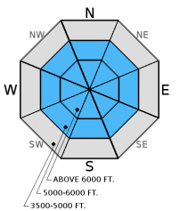
An approaching cold front leads a series of disturbances bringing rain and snow over the next few days. Rain will cause potential wet avalanche problems before it cools. Strong winds and new snow will form wind slabs at mid and upper elevations. The avalanche hazard above 5000 ft. is MODERATE and LOW below 5000 ft., but the hazard could rise if more rain falls than expected during this unsettled spring pattern. Pay attention to rapidly changing conditions.

2. Moderate
?
Above 6500 ft.
2. Moderate
?
5000-6500 ft.
1. Low
?
3500-5000 ft.
- 1. Low
- 2. Moderate
- 3. Considerable
- 4. High
- 5. Extreme
-
Type ?
-
Aspect/Elevation ?

-
Likelihood ?CertainVery LikelyLikelyPossible
 Unlikely
 -
Size ?HistoricVery LargeLargeSmall

Rain on snow will cause instability and wet avalanches will become more of a concern earlier in the day before temperatures begin to drop behind the approaching cold front. Most mountain locations remained well above freezing so the snow surface is already soft. Add some rain to the mix and a a wet avalanche problem emerges. Human triggered wet loose avalanches could become more likely as rain continues today. With rain on snow up to 7000 feet we could even see wet slab avalanches involving the top part of the snowpack particularly on the most upper elevation slopes that still hold dry snow. If the snow surface is becoming wet and you begin to see rollerballs and pinwheels then it is time to move off of steep slopes and out of avalanche terrain. Even small wet loose avalanches can have a big impact in high consequence terrain like cliffs or terrain traps.
-
Type ?
-
Aspect/Elevation ?

-
Likelihood ?CertainVery LikelyLikelyPossible
 Unlikely
 -
Size ?HistoricVery LargeLargeSmall

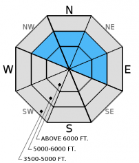
Winds will become moderate to strong as the cold front passes later today forming the new snow into fresh wind slabs. These slabs could build to over a foot thick by tomorrow morning and exist on leeward slopes and cross-loaded gullies. Assessing this problem is fairly straightforward given the wind slabs are confined to the upper snowpack. Perform stability tests on the upper snowpack to identify the sensitivity of these slabs or any other layers of concern.
Additional Concerns: Longer days, warmer temperatures, and even rain may cause large cornices to weaken and fail. It is the time of year to avoid traveling below cornices and stay well behind them while traveling along ridgelines as they can break farther back than expected.
NOTE: Ortovox is recalling the S1+ avalanche transceiver. More info: http://www.ortovox.com/4875--handling_recall.html
The next regularly scheduled advisory will be issued Thursday, April 2, 2015. The final avalanche advisory of the season will be issued Sunday, April 5, 2015.
Cool, wet days interspersed with warm, sunny periods means rapidly changing avalanche hazard and revolving avalanche problems. The series of small storms last week included both rain and snow and resulted in a small to medium sized wet loose and wind slab avalanche cycle. Wind slabs and wet loose avalanches were oberved in the Swan Range on Friday (photo). Yesterday, we observed the reported cornice fall and slab on Flattop Mountain near Marias Pass (photo, observation), and also saw wind slab and wet loose activity up to size 2 (D2) in Tunnel Creek in the Flathead Range from either last Thursday or Saturday (photo 1, photo 2).
The incoming unsettled weather/storm is similar to last week's storms, but perhaps a bit less moisture. However, even though it is very much spring-like with a meager to non-existent snowpack at lower elevations, avalanches (both wet and dry) are still occurring. Paying attention to recent observations and changing conditions is always important especially in spring when things can change rapidly and the avalanche hazard can rise quickly.
A spring pattern of mostly unsettled weather in northwest Montana emerges beginning today through the rest of the week. As of 5:00 a.m., skies are cloudy, temperatures above 6000 ft. range from 31º to 44º F, and winds are moving out of the southwest at 3 to 9 mph with gusts to 15 mph. A slight inversion exists so temperatures at lower elevations are slightly cooler. Today, expect precipitation to begin mid to late morning with rain to 6000-7000 feet. About 0.2-0.4 inches of rain is expected through this evening. Snow levels are expected to drop to 3000 ft. by tonight. The upper elevations could see up to 6-8 inches of new snow by tomorrow night. Winds will move out of the southwest at 15-20 mph with gusts to 45 mph.
| 0600 temperature: | 31-44 deg. F. |
| Max. temperature in the last 24 hours: | 38-51 deg. F. |
| Average wind direction during the last 24 hours: | Southwest |
| Average wind speed during the last 24 hours: | 3-13 mph |
| Maximum wind gust in the last 24 hours: | 25-30 mph |
| New snowfall in the last 24 hours: | 0 inches |
| Total snow depth: | 55-98 inches |
This advisory applies only to backcountry areas outside established ski area boundaries. This advisory describes general avalanche conditions and local variations always occur. This advisory expires at midnight on the posted day unless otherwise noted. The information in this advisory is provided by the USDA Forest Service who is solely responsible for its content.


