| Saturday | Saturday Night | Sunday | |
|---|---|---|---|
| Cloud Cover: | Mostly cloudy, light rain/snow | Light snow showers | Partly/mostly cloudy with light showers |
| Temperatures: | 42-53 deg. F. | 25-31 deg. F. | 43-54 deg. F. |
| Wind Direction: | SW | SW | SW |
| Wind Speed: | 9-10 gusts 25-31 | 13-15 gusts 33-37 | 6-8 |
| Snowfall: | 0-1 in. | 0-1 in. | 0 in. |
| Snow Line: |
Whitefish Range
Swan Range
Flathead Range and Glacier National Park
How to read the forecast
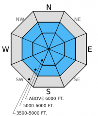
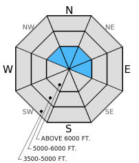
Most locations did not re-freeze over night resulting in a moist snow surface to start the day. The hazard above 5000 feet is MODERATE for the potential to trigger loose, wet avalanches. Pay close attention to rapid changes in the weather. If we get more precipitation than anticipated, and at higher snow levels, the hazard will rise. Carefully assess each slope for unstable surface snow and any lingering instability with recently formed wind slabs at higher elevations.

2. Moderate
?
Above 6500 ft.
2. Moderate
?
5000-6500 ft.
1. Low
?
3500-5000 ft.
- 1. Low
- 2. Moderate
- 3. Considerable
- 4. High
- 5. Extreme
-
Type ?
-
Aspect/Elevation ?

-
Likelihood ?CertainVery LikelyLikelyPossible
 Unlikely
 -
Size ?HistoricVery LargeLargeSmall

Temperatures did not drop below freezing in most locations over night, leaving a moist snow surface to start the day. Though temperatures are expected to be slightly cooler than yesterday, the potential for loose, wet avalanches remains. Light precipitation is expected and should fall as snow above 5000 feet, but spring weather can be full of surprises. If it begins to rain, recent snow will quickly become unstable and you should move out of avalanche terrain and away from terrain traps. The recent storm snow sits on top of a crust that will provide a good sliding surface, below this crust the snow is moist and weak and a small avalanche could gouge into and entrain a substantial amount of snow.
-
Type ?
-
Aspect/Elevation ?

-
Likelihood ?CertainVery LikelyLikelyPossible
 Unlikely
 -
Size ?HistoricVery LargeLargeSmall

Strong winds in the past week drifted recent snow and formed wind slabs at upper elevations. Be sure to assess wind loaded areas for lingering instability, and keep in mind that expected strong, gusty winds today could drift new snow and thicken these slabs as the day progresses.
Additional concern: The possibility exists that a wind slab or wet loose avalanche could step down into deeper wet snow layers and fail as a wet slab avalanche. Thus, it is important to assess not only the recent storm snow, but the wet snow beneath. Additionally, given the time of year with longer days and warmer temperatures large cornices may begin to weaken and fail. Avoid traveling below cornices and stay well behind them while traveling along ridgelines.
Yesterday was another balmy day in the southern Whitefish Range. We traveled out to Skookoleel Ridge and found 4-6 inches of moist, sticky snow on top of a crust formed last week. On sunny slopes we saw signs of surface snow instability like roller balls and pin wheels and a few small wet sluffs. On shaded aspects at high elevation we found crusts still intact in the mid-snow pack, and on sunny aspects, recent melt water and rain moved all the way to the ground leaving a weak, wet structure similar to what we found in the Swan Range on Wednesday (video).
Snowmobile observers, Lucas and Guy were in the Lost Johnny area in the Swan Range yesterday where they observed several recent loose, wet avalanches.(photo)
Skiers in the Flathead Range near Marias Pass last week noted 10 inches of recent snow and active wind drifting that created fresh wind slabs (observation).
Spring-like weather continued yesterday with filtered sun and temperatures reaching the mid to upper 40s. Winds were out of the southwest at 5-10 mph gusting to the mid 20s. Currently, mountain temperatures range from 30º-41º F and winds continue to blow out of the southwest 4-10 mph with gusts from 12-15 mph. Today expect mostly cloudy skies, with slightly cooler temperatures. A weakening system is expected to move in to the area mid-day and bring a bit of upper-elevation snow and light rain at the lower elevations. Winds will increase this afternoon to 10-20 mph with gusts in the 30s on the ridges.
| 0600 temperature: | 30-41 deg. F. |
| Max. temperature in the last 24 hours: | 38-47 deg. F. |
| Average wind direction during the last 24 hours: | SW |
| Average wind speed during the last 24 hours: | 5-10 mph |
| Maximum wind gust in the last 24 hours: | 15-23 mph |
| New snowfall in the last 24 hours: | 0 inches |
| Total snow depth: | 60-96 inches |
This advisory applies only to backcountry areas outside established ski area boundaries. This advisory describes general avalanche conditions and local variations always occur. This advisory expires at midnight on the posted day unless otherwise noted. The information in this advisory is provided by the USDA Forest Service who is solely responsible for its content.


